
Anna – psst!
Anna – psst!
Anna wants her peace. Her questions give none.
Anna is 14, part of the Remswelle initiative – and asks the questions hardly anyone thinks of any more, because the obvious has become too obvious to question. "Could we use the Monopteros as a lighthouse some day?", for instance. Sounds mad. And leads straight to sea levels, elevation models and the question of what structures can be good for. We collect such questions here. Some we can answer, some not yet – and then it says so, honestly: we are finding out.
The comic Anna on these pages is an AI-generated illustration. Even the maddest question gets a serious answer here – that is this section's only rule.
Anna – psst!Why doesn't the Rems flow the other way round?
Read the answerClose
Who tells the water where to go? The short answer: gravity. The long answer is better – because geologists reconstruct that parts of today's Rems region once drained in the opposite direction: towards the Danube instead of the Neckar. In today's valley at Winterbach our terrain models show no trace of it – but near Essingen, where the Rems rises, we found a valley that today drains in two directions. A seemingly silly question – and the start of a real search. → One valley, two directions
Anna – psst!Could we use the Monopteros as a lighthouse some day?
Read the answerClose
It is solidly built and tall enough – only the sea is missing. It would have to reach Winterbach, and that will not happen. The ice at the North Pole floats on the water; when it melts, the sea level hardly rises. What matters are the thick ice sheets on land: in Antarctica at the South Pole and on Greenland, plus all the mountain glaciers. Even if all of that melted, the sea would rise by only about 66 metres. But Winterbach lies 245 metres up – almost four times as high. So the Monopteros will never have a lighthouse job. But the question behind it is clever: can a structure serve more than one purpose? The Monopteros is a landmark and a viewpoint. And the outlet structure at Ostlandstraße protects against floods – whether it can also make a wave in the Rems possible on the side is exactly the question our initiative asks. → The project
Anna – psst!Can there actually be too many bees?
Read the answerClose
Yes, there can – at least too many of one kind. Honey bees live in colonies with tens of thousands of foragers; where little blooms in high summer, they can make food scarce for wild bees and other insects. Surprising, isn't it? The whole story, with flight ranges and a bloom calendar: → Too many bees?
Anna – psst!Can you save rain for the summer?
Read the answerClose
Not for long in a water butt, at any rate – and a full butt is no help at all in a flood. That is the Winterbach cistern paradox: storage that is always full cannot take anything in. Whoever really wants to "save" rain needs soil, meadows and a landscape that swallows water and gives it back slowly. → Sponge landscape Winterbach
Anna – psst!If the wave stands still – am I even surfing?
Read the answerClose
In the sea you travel with the wave. On a river wave you stay in one place while the water rushes through beneath you. Standing still and surfing all the same – how that works physically is explained by one of hydraulic engineering's finest ideas: the hydraulic jump. → How a standing wave forms
Anna – psst!Did children use to walk this far to the sports ground too?
Read the answerClose
No – kick-about meadows used to lie in the middle of the village, as old aerial photographs show. Today it is quite a way to the sports grounds for many children; how far, and how flat the route is, you can even measure yourself on our map. → How far is it for you? Measure it yourself · → Children and young people
Anna – psst!Has Winterbach forgotten a wave?
Read the answerClose
Perhaps. Three hundred years ago, during the timber drift, water shot through a chute in the Winterbach mill weir – and the State Archives hold a file titled "Floßgasse zu Winterbach". Whether a wave ever stood behind it? That is the search we are working on right now. → The forgotten wave of Winterbach
Anna – psst!Can our wave become UNESCO cultural heritage?
Read the answerClose
The wave itself cannot – you cannot build cultural heritage, you have to live it: what is protected are customs and skills that people pass on across generations. But here is the thing: the story our wave belongs to already is one! Timber rafting was inscribed on the UNESCO list of intangible cultural heritage in 2022 – and the timber drift on the Rems is its forgotten chapter. And cultural heritage always starts with somebody starting. → The forgotten wave of Winterbach
Anna – psst!Was this really once the sea?
Read the answerClose
Yes! Around 183 million years ago a shallow sea covered all of southern Germany – half an hour's drive from here, in Holzmaden, you can still find ichthyosaurs and ammonites from it today. That Winterbach now lies 245 metres up is not because the sea was especially high: the land was lifted later. Will the sea ever come back? Anna's lighthouse question answers that. → When this was sea
Anna – psst!Why is it warmer in the village at night than at the edge of the woods?
Read the answerClose
Because meadows, fields and woods on the slopes cool down quickly on clear nights – and the cold air, heavier than warm air, flows downhill like water. Houses and streets, on the other hand, have stored heat during the day and release it at night. Where the cool air reaches the village it becomes pleasant; where it does not, it stays warm. How these air currents run through Winterbach: → Cool air for Winterbach
Anna – psst!Why do Munich and Nuremberg have a wave – and we don't?
Read the answerClose
Good question! 2.8 million people live in the Stuttgart region – almost as many as in the whole Nuremberg metropolitan region. Nuremberg has one river wave, Munich even two, the Stuttgart region none. Anyone here who wants to surf drives to Pforzheim, Munich or Nuremberg. That very gap is why the initiative exists. → The site in Winterbach · → All river waves in Germany, Austria and Switzerland
Anna – psst!When it gets warmer – will wine like Bordeaux's soon grow here?
Read the answerClose
Perhaps on some slopes. By around 2045 the Hungerberg could be as warm as the Kaiserstuhl or Burgundy are today – roughly what Bordeaux had as its long-term average. Whether red wine would really grow there depends on much more than warmth, though: on soil, slope, water and frost. We play it through as a thought experiment. → Vineyards of tomorrow
Anna – psst!Can you surf from the Rems all the way to the sea?
Read the answerClose
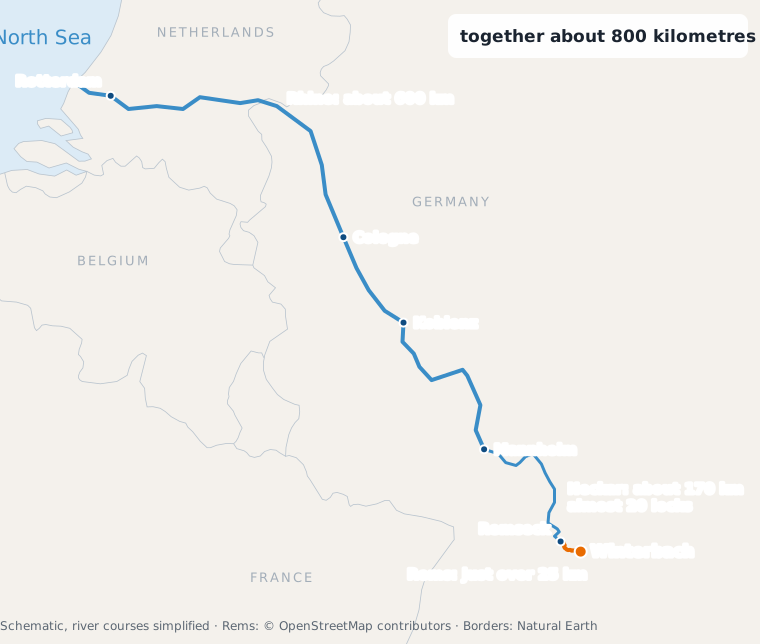
Not surf – but paddle! On a stand-up paddle board, or SUP, you could get from Winterbach to the North Sea. The Rems flows into the Neckar at Remseck, the Neckar into the Rhine at Mannheim, and the Rhine into the sea near Rotterdam. Together that is about 800 kilometres: just over 25 on the Rems, about 170 on the Neckar, about 600 on the Rhine. It would not be easy. Even on the Rems there are weirs you have to carry around; on the Neckar there are almost 20 barrages with locks; and on the Rhine you share the water with big cargo ships that cannot brake and often cannot even see paddlers. In 2020 one adult paddler covered about 950 kilometres on the Rhine on a home-made wooden SUP, from Switzerland to the Netherlands – in 27 days. For children: only with adults, with a life jacket and never near weirs or big ships. → The Rems at Winterbach
Anna – psst!How can the Rems have more surf days without more rain?
Read the answerClose
By letting the rain that falls anyway arrive more slowly. If it pelts down on hard, bare ground, it shoots through the Rems in a day or two – first there is too much water, then too little. If it falls on loose soil, meadows and woodland, the landscape soaks it up like a sponge and releases it over days and weeks. The same amount of rain – but more days with enough water in the Rems. By our rough calculation that could mean 15 to 23 more surf days a year if the landscape above Winterbach held back a fifth of the fast runoff for longer. And the best part: what helps the wave also helps the fish, the gardens and the groundwater. → What does all this have to do with surfing?
Anna – psst!Is the little step in the river by the bird tower the animals' secret meeting place?
Read the answerClose
A bit, yes – at least for animals that like fast, oxygen-rich water. Where the Rems splashes over the step before the Remsknie, it whirls air into the water, and below it digs itself a deeper pool. Insect larvae and small crustaceans such as freshwater shrimps live on the stones, fish find food and hiding places, and birds such as the dipper or the grey wagtail like to hunt at places like this. We see lots of sticklebacks there, for example. But the step has a downside: for small fish and crustaceans even a step of ten or twenty centimetres is a wall they cannot get over going upstream. So the fact that so many gather below it can also mean: this is as far as it goes. That is why such steps are often rebuilt today as gentle, rough ramps. → Wildlife and plants along the Rems · → Weirs and fish passage
Anna – psst!Is surfing more like snowboarding or skateboarding?
Read the answerClose
More like snowboarding – with a dash of skateboarding. As on a snowboard you glide instead of rolling, and you steer by putting the board on its edge. On a river wave you stay almost on the spot while the water rushes beneath you – a bit like snowboarding in deep powder. Surfing shares its origins with the skateboard: surfers in California invented skateboarding for days without waves and called it "sidewalk surfing". The snowboard has a surfing ancestor too, the "Snurfer" of 1965. In all three you stand sideways, left foot forward ("regular") or right foot forward ("goofy"). And what does only the surfboard have? Fins: small blades under the tail that keep the board on track like a keel and give grip in turns. River boards are short and usually have small fins, often soft ones for beginners. But it works without them too: the old Hawaiians surfed finless wooden boards, the alaia – held only by their sharp edges. Skimboards still have no fins today. → How to surf a river wave · → Surfing without a wave
Anna – psst!Why can't I take water from the stream in summer?
Read the answerClose
Because the stream badly needs it itself. In summer 2026 the district office banned taking water from streams and rivers – from every little stream just as from the Rems, even with a watering can. At low water the water gets warm, oxygen runs short, dirt becomes concentrated and fish are stuck in isolated pools. Every bucket is missing for them. Water for the garden is better taken from the rain barrel or cistern – water you caught beforehand. → When the Rems runs low
Anna – psst!Why should I water the garden in winter?
Read the answerClose
Not for the plants – for the next rain! Hardly anyone waters in winter, so the cistern is brim-full. When days of rain come, it overflows, and all the water from the roof rushes into the sewer and the stream. But winter and spring are exactly when the big Rems floods come. The trick: when a lot of rain is forecast, drain part of the cistern beforehand and let the water soak into the lawn. Then the cistern has room again and catches the rain. Important: not onto frozen or already muddy ground – and not down the drain, or the water is straight back in the stream. → The Winterbach cistern paradox
Anna – psst!Is a landslide something like an avalanche – just without snow?
Read the answerClose
Pretty much! In both, something heavy slides down the slope on a slippery layer – in an avalanche, snow on a weak layer of snow; in a landslide, earth and stone on wet clay. And for both you ask the same things: How steep is the slope? Is there a sliding layer? And how "full" is it right now – of new snow for the avalanche, of water for the slope? One difference: avalanches come in minutes, slopes often give warning long before – with cracks, leaning trees and wet patches. In Urbach a whole slope slid away in 2001, and the rocks here are the same. That is why it is worth being able to read slopes the way a ski tourer reads snow. → Why slopes slide
Anna – psst!Why is it called Streuobst – "scattered fruit"?
Read the answerClose
Because the trees stand as if scattered across the landscape: one by one, tall, with plenty of space – not in long rows as in a fruit plantation. They are standard trees: the crown starts only above 1.60 metres, you can walk underneath, and the trees grow up to 20 metres tall and up to 100 years old. They stand at least 8 metres apart. In a fruit plantation, by contrast, you find low-stemmed trees: small trees whose crown starts at half a metre. They stay about 5 metres tall, stand close together in rows and bear fruit for only 15 to 20 years – with narrow strips of grass between them. In an orchard meadow, the meadow beneath is the main thing: it is mown or grazed. So the same patch gives apples, pears or cherries above and hay below – with room for birds, insects and bats in between. On the Hungerberg, by the way, many of these trees stand where vines used to grow. Beneath them, the deeply trenched vineyard soil lies to this day. → Forest or meadow? · → The soil shows where vines stood
Anna – psst!Why can you walk along the Rems in the middle of Plüderhausen – but not here?
Read the answerClose
“Our Rems flows right through Winterbach. But if I just want to walk along the water, I hardly can in the village centre. Plüderhausen has a real promenade on the Rems. What could we learn from them?”
Plüderhausen redesigned its riverbank for the Remstal Garden Show 2019: opposite the old town hall a promenade with a wooden boardwalk was built. It creates a new link on foot and brings the Rems closer to people. Winterbach built something for the Garden Show too – the access at Gleisdorfer Platz with stone steps and a wooden deck. But from there you cannot go on along the water: between Gleisdorfer Platz and the Remswehr, gardens reach down to the bank on the south side and commercial land on the north side. Below the village, along the restored stretch, you can walk beside the Rems well.
We counted: according to OpenStreetMap, paths run along both banks for 43 per cent of the Rems in Plüderhausen, and for 11 per cent in Winterbach. Whether and where a riverside path would be possible here depends on ownership, flood protection and nature conservation, and has to be clarified with the municipality and experts. We have already sketched what it could look like – from Gleisdorfer Platz along the water to the Remswehr and back on the other bank. → Riverside paths on the Rems: our ideas
Anna – psst!Is the Hungerberg steeper than a ski run?
Read the answerClose
In places, yes! Ski runs are graded by their gradient: a blue run has at most 25 per cent, a red one up to 40 per cent, a black one more. On the Hungerberg the slope in the landslide area is about 34 per cent steep on average – that would be a red run. The steepest ravines of the Schurwald would even be black. We just don't get snow often enough, and there is no lift either. You can measure how steep it is where you are. → How steep is it here? Measure it yourself
Have you got a question like this?
Questions that sound too mad to ask are often the best ones. If one occurs to you – about water, the village, the landscape or the wave – send it to us via the contact details in the Impressum (German). The best ones get an answer here. Anna helps choose.
Frequently asked questions
Is Anna real?
Yes. Anna is 14, part of the initiative, and really asks questions like these. The comic figure is an AI-generated illustration; more about the people behind the initiative is on About us.
Is this a children's page?
No – a questions page. That the best questions come from a 14-year-old does not make the answers simple: behind each one stands one of our investigations, with sources. Why the Rems does not flow the other way round is not a children's question. It is a remarkably good question.
Sources: Ski-run question – Salzburger Nachrichten, “Mit System durchs Skigebiet” (run colours under DIN 32912 and ÖNORM S 4610 f); riverside-path question – Jedamzik + Partner, project page “Remstalgartenschau Plüderhausen” (promenade with wooden boardwalk, planned and built 2015–2019); path shares: own analysis © OpenStreetMap contributors (ODbL). The answers rest on the pages linked above and their sources. In addition: sea question – Wikipedia "Rems" and "Neckar" (27 barrages Plochingen–Mannheim), Aldingen barrage (above the mouth of the Rems), International Commission for the Hydrology of the Rhine Basin (CHR), "Length of the Rhine" (2015), SUPboarder Magazine, 04.01.2023 (2020 trip), North Rhine-Westphalia police, "Rudern und Kanusport" (2023), Rems: © OpenStreetMap contributors, borders: Natural Earth · bird-tower question – NABU portraits of the dipper and grey wagtail; waldwissen.net, "Gewässer im Wald" (steps over 10 cm); own observation (sticklebacks) · snowboard question – Wikipedia "Skateboarding", "Snurfer", "Goofy footed", "Alaia", "Surfboard fin"; Blue Tomato, "How to surf river waves" · stream question – general order of the Rems-Murr district office of 23.06.2026 (via the municipality of Urbach) · orchard question – NABU, "Streuobstwissen"; Bavarian State Research Center for Agriculture, "Streuobst – Unterscheidungsmerkmale"
The "psst!" is real, by the way: that is what Anna does when she wants her peace. The questions come anyway – and there is even a song about it.
Last updated: 15 October 2026 · Initiative Remswelle