
Rems and Winterbach · River, water, nature and history
Cool air for Winterbach
Anyone who surfs or windsurfs inevitably deals with weather and climate: wind, air pressure, temperature and currents decide whether there are waves and wind – and those who read them well get more days on the board. That stays with us at home too. So we look at Winterbach with the same eye: where does the cool air flow at night, where does the heat build up in the village? What we notice, we write down here.
On clear, calm summer nights, meadows, fields and forests on the slopes cool down quickly. The cold air is heavier than the warm air and flows – much like water – downhill, collects in the valleys and runs through them down into the Rems valley. Where it reaches the village, it brings relief after a hot day. What this looks like in Winterbach is shown by the Baden-Württemberg climate atlas (Klimaatlas), published by the State Institute for the Environment (LUBW) in January 2025. It models a typical summer night for the whole state. The model grid is coarse; it is suitable for statements about districts and valleys, not about individual houses.
Three currents
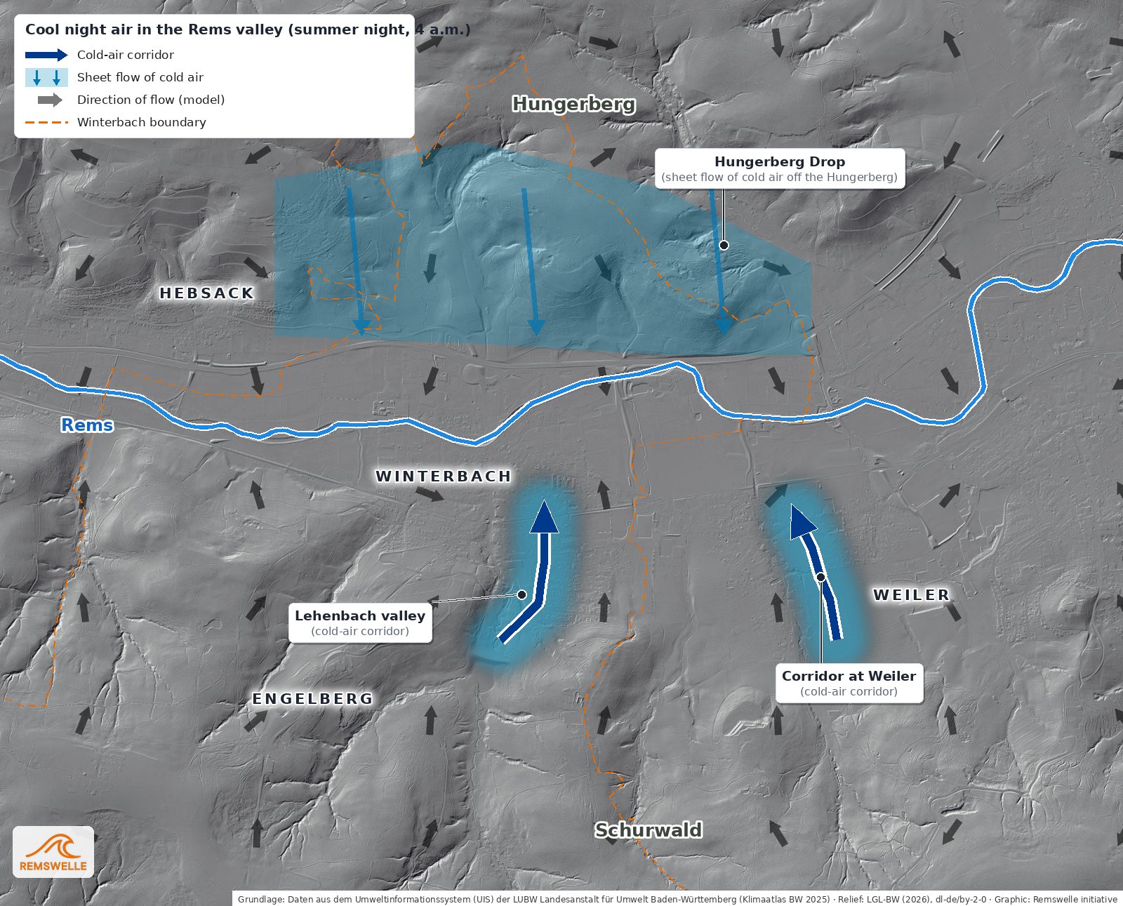
Cold-air corridor Lehenbach valley. The cold air flows from the Lehenbach valley down from the Schurwald north into the village – from the forest towards the village. The climate atlas model traces the corridor to just short of the old village centre.
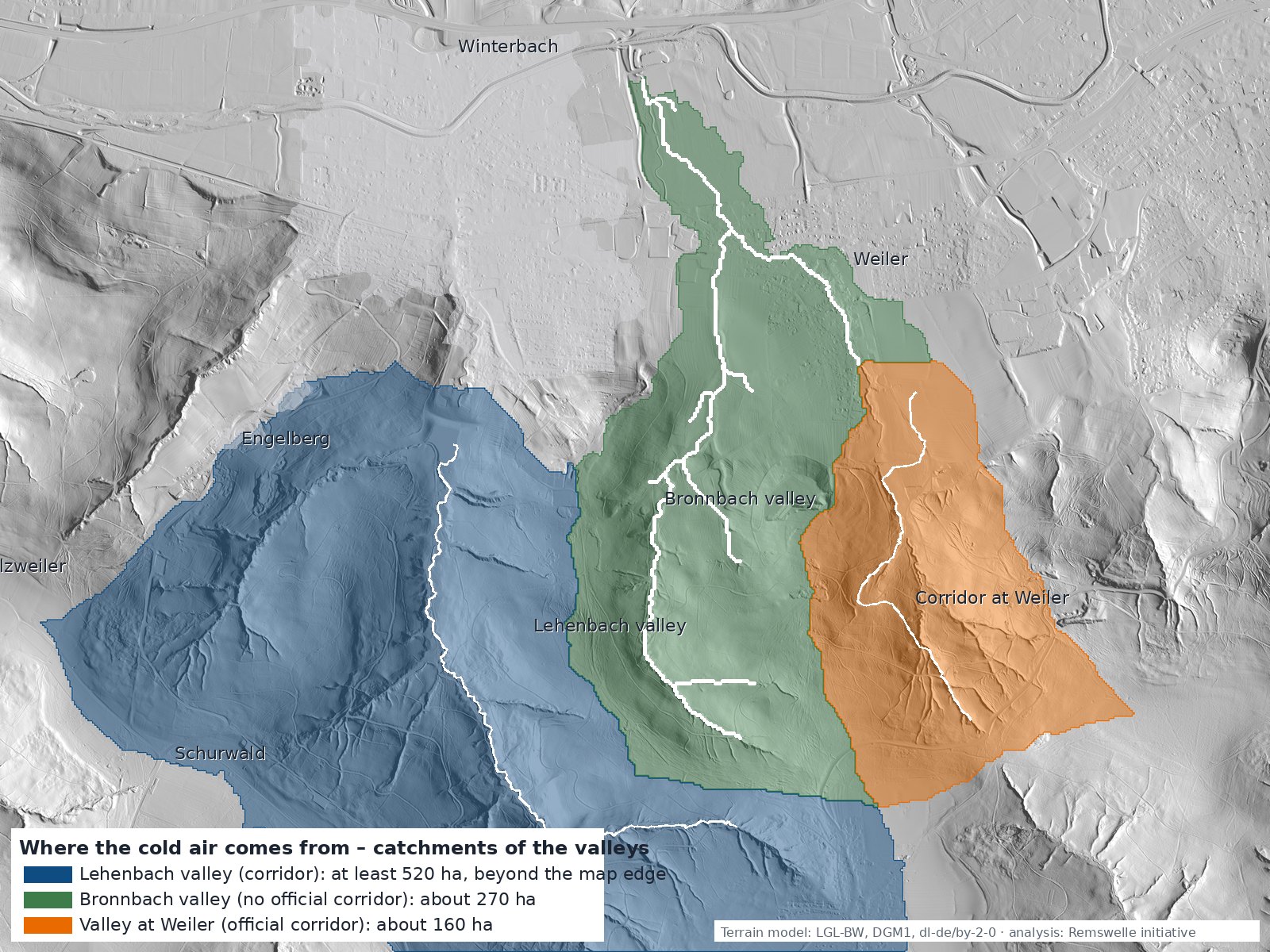
Cold-air corridor at Weiler. It brings cool air from the valley at the Weiler rifle club into the Rems valley, where it turns west towards Winterbach. What this valley is called we are still clarifying; the stream there is named Weilerbach on the maps. Right beside it, less than 700 metres to the west, the Bronnbach valley opens out – the valley below the Sterrenberg, officially so named after the landscape protection area "Stärrenberg-Bronnbachtal". The climate atlas designates no corridor of its own there; but the terrain suggests that cold air flows from it into the Rems valley as well, and down in the valley the two flows merge anyway (see "Where the cold air comes from").
Hungerberg-Drop (sheet flow of cold air from the Hungerberg). On the north side there is no single corridor: from the Hungerberg the cold air flows broadly over the whole slope down to the Rems.
You can feel cold air. On a summer evening you notice it on your arms and legs when you walk out of the village into one of the valleys or up the slope – it is often noticeably cooler there. If you want to know more precisely, take a thermometer on your walk and note where it is how warm. That does not replace a weather station, but it makes the currents tangible. Why this does not work on some nights is explained under the "trapped-heat night". → Wind and weather in Winterbach The idea is not new, by the way: as early as 1930 the local homeopathic association laid out a light-and-air bath at the Höffenklinge – cool hillside air, spring water and a view as a cure. → Springs and hillside water
When valleys make wind – what surfers know about it
That valleys not only receive air but bundle, steer and accelerate it is something every windsurfer knows from their home spots – and windsurfers are demanding readers of terrain, because for them the wind is the spot: valley mouths, headlands and ridge lines are read there the way others read weather charts. At Lake Garda, in the cool half of the day, cold air from the Central Alps streams through the north–south valleys towards the Po plain – the Pelèr that gets surfers onto the water in the morning; the valleys act like wind locks, and the funnel-shaped narrowing of the northern lake strengthens the flow. In the afternoon the system reverses: the Ora blows up the lake from the south, and the official description of the area explicitly names the narrowing in the north and the Venturi effect as the reason for its strength. At Viana do Castelo on Portugal's Atlantic coast the driver is different – the northerly Nortada, thermally charged – but the lesson is the same: the hills above the beaches accelerate the wind so much that far more blows at the spot than the large-scale forecast says.
Surfers read the terrain differently again – under water and on land at once. Whether and how a wave breaks is decided by the bottom: at Uluwatu on the southern tip of Bali five different waves break on the same limestone coast, because the reef in front of the cliffs runs out shallow and deep channels on both sides of the peninsula steer the south-westerly swell onto it – fast and hollow in one place, long and even in another, depending on how the reef lies. And surfers know the cold air from the valleys from the other side: they wish for an offshore wind, because wind from the land combs the waves, keeps their face smooth and lets them stand up steeply instead of toppling them early. At Uluwatu that is the south-easterly trade wind of the dry season; on many other coasts the early-morning offshore arises exactly as it does in Winterbach at night: the air over the land cools, becomes heavy and flows down through the valleys to the coast. The best session of the day is often a cold-air drainage flow.
Winterbach is neither Lake Garda nor the Atlantic, and the cold air of a summer night is no surfing wind. But the physical principle is the same one the climate atlas describes for the Lehenbach valley and the corridor at Weiler: cold air forms on the slopes, the terrain collects it, the valley guides it, and what arrives at the valley mouth is what the valley's shape makes of it. It is exactly this chain of effects that makes the two corridors exciting for us – and testable.
A summer night in Winterbach
The slider takes you through a hot summer night: first where the village stays warm, then where the cool air forms, how it flows and which paths it takes.
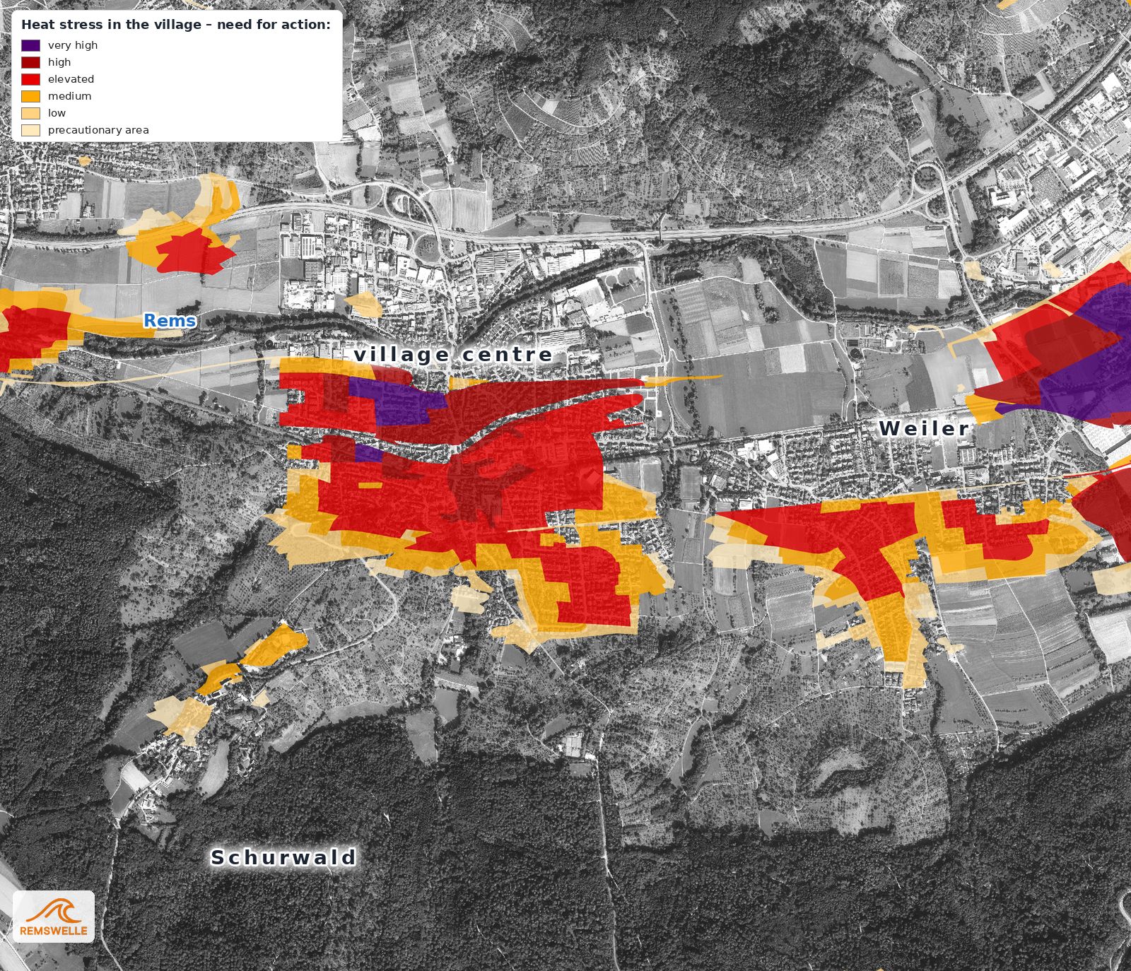
After a hot day: where the climate atlas sees heat stress at night – the darker, the greater the need for action, above all in the densely built parts in the valley.
Cold air and buildings
Cold air flows where it can get through: through valleys, over meadows, through wide streets and gardens. Buildings standing across its path, dense development or embankments can slow it down. That is why it plays a role in planning. Two examples from Winterbach development plans:
Ball sports hall at the sports centre, 1995. Three possible sites for the hall were examined in 1991/92; at the end of 1994 the municipal council decided on an extension west of the Salier-Halle, "above all" for urban planning and functional reasons. Climate considerations were also taken into account. And the closeness of the Rems showed in the ground: a soil survey in May 1994 found the floodplain soil so weak that the hall had to be built on piles.
Riedwiesen housing area, 2021. The development plan was drawn up in the accelerated procedure under § 13b of the Federal Building Code, which does not require an environmental report. On climate, the explanatory statement mentions "adequate daylight and ventilation".
With the climate atlas there is now a state-wide basis that every plan can use. → Riverside paths along the Rems · → Flood protection
Keeping the cold-air corridors open also keeps the sponge areas open. Cold air can only flow over open land: over meadows, orchards, fields and the floodplain. These are exactly the areas that also absorb rain and release it slowly. A building or a sealed surface in a corridor slows both – the cool air and the water. That is why we stand up for keeping the cold-air system around Winterbach undisturbed: for cool nights in the village and for soils that hold water. → What does all this have to do with surfing?
What we want to test
The climate atlas is a model, not a measurement. Whether and how strongly the cold air from the Lehenbach valley, the corridor at Weiler and the Bronnbach valley actually reaches the Rems is something we want to find out in three steps. First, the terrain: with the state's terrain model we draw longitudinal and cross profiles through both valleys – gradient, narrows, valley mouths and their angle to the Rems, plus the areas above them where the cold air forms. The result is below under "What the terrain shows". Second, measure: in a season with many clear nights we want to record wind direction, wind speed and temperature at several points at once – in the valley, at the valley mouth, on the bank of the Rems and, for comparison, at a spot outside the corridors. We already have the anemometers from surfing. Third, evaluate: the clear, calm nights are the interesting ones. If a recurring pattern shows up in them – first cooling in the valley, then a directed flow along the valley axis, then a signal at the valley mouth and at the Rems – the corridor is not just calculated but measured. Only several such nights allow a robust statement; until then it remains a hypothesis, which we name openly here.
What the terrain shows – step one
We have taken the first step: we measured both valleys in the state's terrain model – valley floor, gradient, width and the direction in which they open towards the Rems valley.
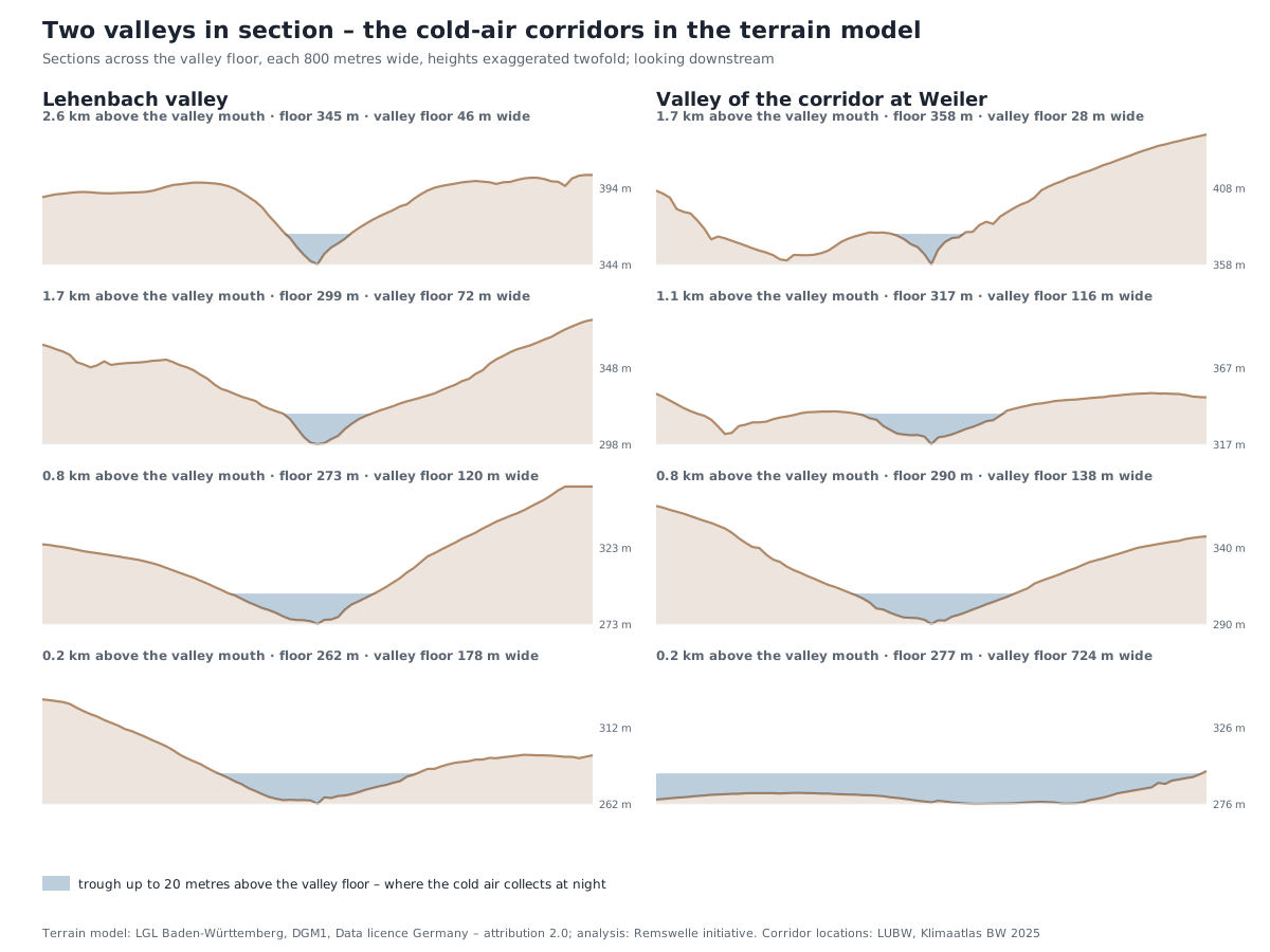
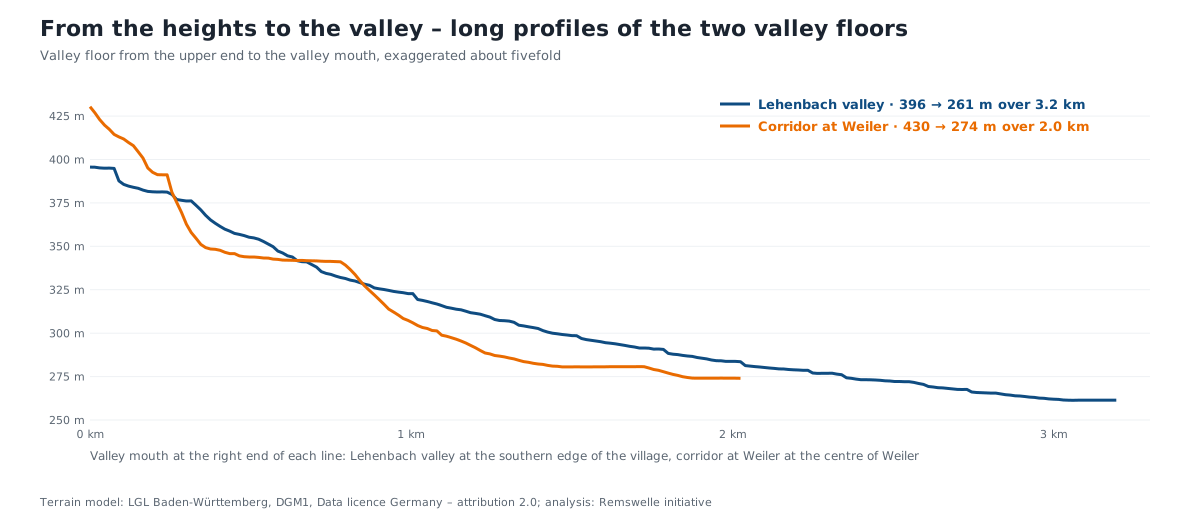
The Lehenbach valley is a long, enclosed channel. From the Schurwald at almost 400 metres the valley floor drops 135 metres over a good three kilometres to the reservoir at the southern edge of the village – on average a good four per cent, steeper at the top, gentler below. The valley floor is narrow, 50 to 120 metres, and opens up only at the mouth to almost 200 metres; the flanks on both sides are more than 50 metres high almost everywhere. That is the shape that collects and guides cold air: a trough from which the cold air can escape only downhill. The valley opens exactly northward, that is across the Rems valley. From the mouth to the Rems it is another 900 metres or so through the village, with 20 metres of fall – the climate atlas takes the corridor to just short of the old village centre.
The valley of the corridor at Weiler is shorter and almost twice as steep: two kilometres, 155 metres of drop, narrow in its upper part with a gradient of almost eight per cent. About halfway down it widens into a basin, and in its lower part, where Weiler lies, it runs out into an open trough 500 to 700 metres wide. Cold air comes down faster here, but spreads out across the width below instead of staying bundled. The valley opens to the north-north-west; according to the climate atlas the flow turns west in the Rems valley, towards Winterbach.
Where the cold air comes from. Cold air flows downhill like water, only more sluggishly. So the terrain model also shows which areas a valley can "serve" at all: its catchment. For the Lehenbach valley that is at least 520 hectares of Schurwald – the edge of the model cuts the area off to the south, in reality it is larger – almost two thirds of it above 350 metres. The corridor at Weiler collects about 160 hectares. And between the two lies the Bronnbach valley below the Sterrenberg, for which the climate atlas designates no corridor, but which with about 270 hectares has the second-largest catchment. Its cold air reaches the Rems valley at the western edge of Weiler, less than 700 metres from the corridor, and merges there with its westward flow – so for Winterbach it counts too. Whether meadow, field or forest lies on these areas the terrain does not say; the climate atlas above under "Cold air forms" shows that: open meadows and fields cool most strongly at night, forest stays milder but delivers evenly.
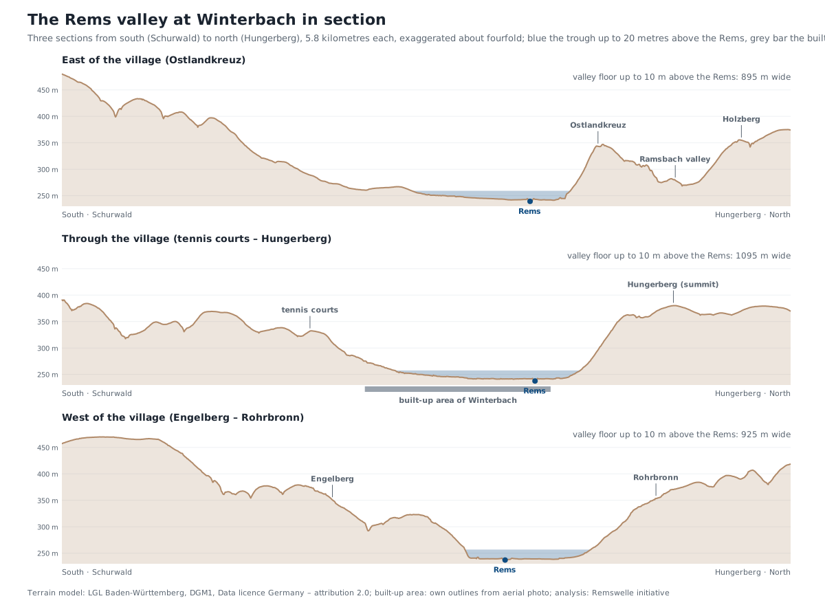
And the Rems valley itself? Three sections across the valley – east of the village over the Ostlandkreuz, through the village from the tennis courts to the Hungerberg, and west from Engelberg to Rohrbronn – show where the cold air ends up: in a wide, flat trough. The valley floor up to ten metres above the Rems is 900 to 1,100 metres wide, and the valley is built unevenly: from the south the Schurwald comes down gently over three kilometres, to the north the Hungerberg rises steeply. In the middle section the built-up area lies almost entirely in this trough, from the foot of the Schurwald to beyond the Rems. That is why the night air from the valleys matters for the village – and why it does not flow far in the valley but pools.
What the terrain does not say: how much cold air actually arrives, how fast it flows and what the buildings at the valley mouth do with it. That is what steps two and three are for.
What this means for the Remswelle
A wave in the Rems changes nothing about the cold air: it lies in the river bed, where the cool air arrives at the end of its journey anyway. But a place by the water where you can sit and watch on hot summer evenings fits well with a valley into which the air flows down from both slopes at night. → The site · → Why paths by the water do you good
Frequently asked questions
What is a cold-air corridor?
A valley or open strip through which cool air flows into a village from its surroundings at night. In Winterbach, according to the climate atlas, these are the Lehenbach valley and the Bronnbach valley near Weiler.
Where do the maps come from?
From the Baden-Württemberg climate atlas of the State Institute for the Environment (LUBW), published in January 2025. It shows a model of a typical summer night, not a measurement.
Can the maps tell how cool it is in my street?
No. The model uses a coarse grid and is suitable for districts and valleys, not for individual streets or houses.
Sources: SURF magazine, "Wind special: Ora and Vento on Lake Garda" (cold air from the Central Alps, valleys as wind locks, Venturi effect) · Garda Trentino, "Winds on Lake Garda", official description of Pelèr and Ora · Windsurf Magazine, "Viana do Castelo – Feel Viana" (thermally enhanced Nortada, acceleration by the coastal hills) · SurferToday, "Uluwatu: the five world-class reef break waves of Bali" (limestone cliffs, shallow coral reef, deep-water channels, S–SW swell, offshore winds from S through E to N) · LUBW, management plan FFH area 7123-441 (landscape protection area "Stärrenberg-Bronnbachtal", Weiler and Winterbach) · Wikipedia, "Brunnbach" (Brunnbach/Bronnbach as headwater of the Weilerbach system) · OpenStreetMap contributors (stream names Brunnbach, Weilerbach) · LUBW, Klimaatlas Baden-Württemberg (published 22.01.2025, www.klimaatlas-bw.de), map services climate analysis map and planning advice map, current situation, accessed 27.09.2026 – Grundlage: Daten aus dem Umweltinformationssystem (UIS) der LUBW Landesanstalt für Umwelt Baden-Württemberg · Relief and aerial photograph: LGL Baden-Württemberg, digital terrain model (hillshade) and digital orthophoto, Datenlizenz Deutschland – Namensnennung 2.0 · Gemeinde Winterbach (municipality of Winterbach), development plans: amendment of development plan Sportzentrum, ball sports hall, explanatory statement (January 1995); development plan Riedwiesen, explanatory statement (as of 05.11.2021) · Climate considerations and pile foundation of the ball sports hall: information from the initiative
Last updated: 15 October 2026 · Initiative Remswelle