
Rems and Winterbach · River, water, nature and history
Basins, lakes and ponds
What holds water back in Winterbach – and what only looks as if it does
Think of heavy rain and floods, look at a pond, and it is tempting to think: the water can go there. That is only true if there is room. A basin that is already full of water takes nothing more – just like a full rain barrel, as we know from the Winterbach cistern paradox. We went through all the larger water bodies in the Winterbach municipal area with the state terrain model: where is the water level, how much room is there above it, and does flood water reach it at all?
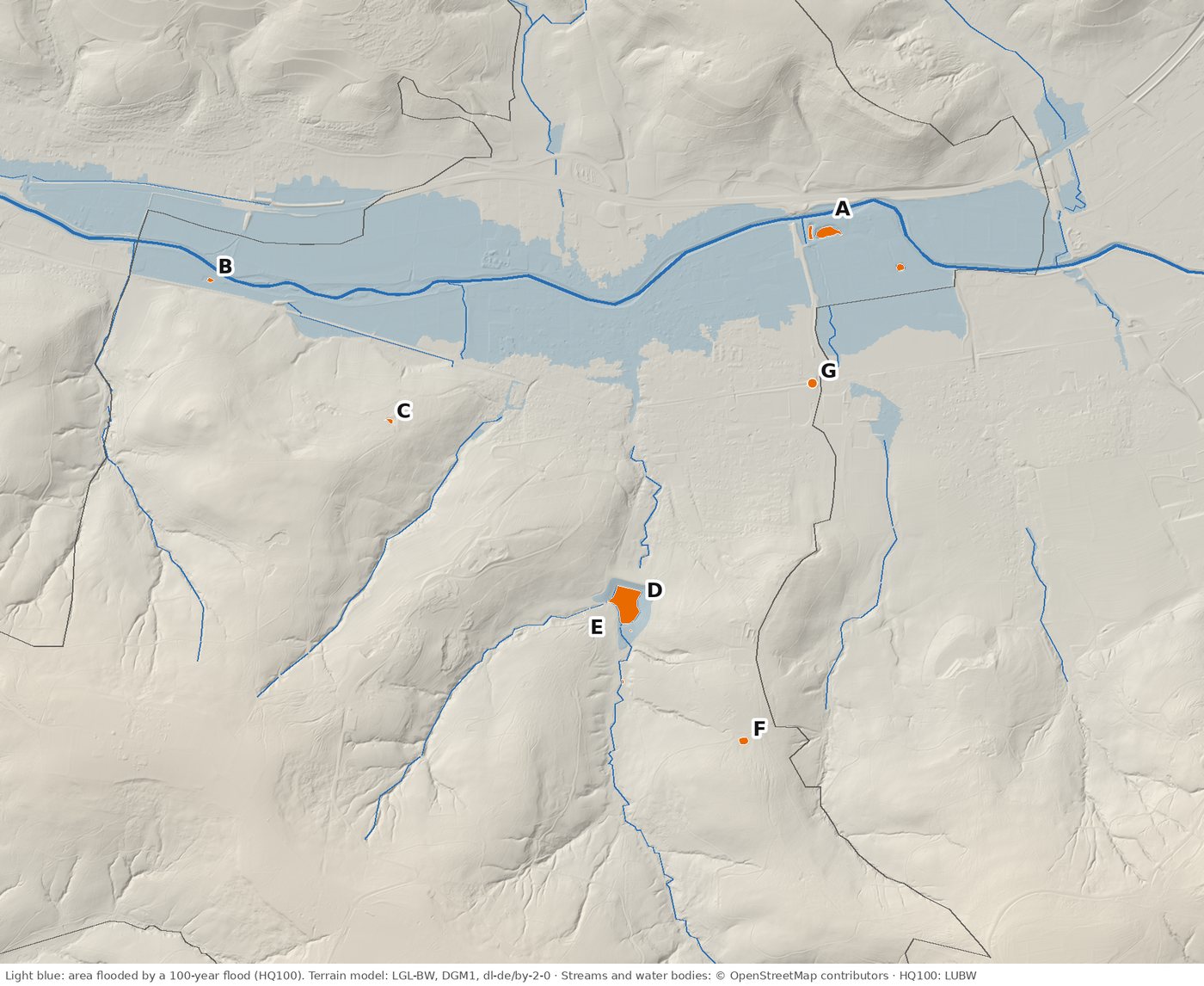
The water bodies at a glance
| What | Area | Water level or bottom | During a flood | |
|---|---|---|---|---|
| A | Lakes by the Rems in a former gravel pit of the Uetz road-building company (three basins) | about 4,000 + 1,100 + 900 m² | about 238–239 m, level with the Rems | in the flood zone; already full – only the room above the water counts |
| B | Pond by the Hebsack bridge | about 490 m² | about 237 m | in the flood zone; already full |
| C | Weihersee pond by the Monopteros | about 460 m² | about 308 m | on the slope; pond in a park, small buffer |
| D | Lehenbach reservoir | permanent pool about 15,700 m² | about 261.4 m | retention basin: about 452,000 m³ of room above the permanent pool |
| E | Ponds and biotope by the reservoir | small | – | habitat, no significant retention |
| F | Basin by the forest sports ground | about 1,200 m² | about 343 m | on the slope; full when measured, purpose unknown to us |
| G | Catch basin by the railway underpass | about 330 m², up to 1.3 m deep | bottom about 246 m | just outside the flood areas; dry when measured, holds about 250 m³ |
How to read the table: Areas and heights come from the state terrain model, an airborne laser survey. Where there is water, the laser measures the surface, not the bottom – so we can see whether a basin was full, but not how deep it is. "In the flood zone" means: in a flood that occurs on average once in a hundred years, Rems water would stand there.
Our water map shows all the ponds and lakes, the streams and the springs. The letters on the map refer to the table.
What counts: the room above the water level
During a flood, a basin holds back only as much as there is room for between its water level and the flood level. At the gravel-pit lakes by the Rems (A) and the pond by the Hebsack bridge (B) the water level is at the height of the Rems. They depend on the groundwater of the floodplain, which rises and falls with the river. By the time the Rems overflows its banks, they are long full. Then only the strip of bank above the water level works – and it would work just the same if a meadow lay there. As retention, these lakes hardly count.
That does not make them worthless. Still waters in the floodplain are habitat for dragonflies, amphibians and water birds, and a former gravel pit can become a valuable biotope. One should just not believe that they protect the village centre from floods.
The Lehenbach reservoir – the one big basin
The only basin in the municipal area that can really take a lot of water in heavy rain is the Lehenbach reservoir (D). It was built in 1963/64 with an 18-metre earth dam. The aerial photo from 1953 shows the valley before: meadows, fruit trees, the stream. Fifteen years later the dam is there.
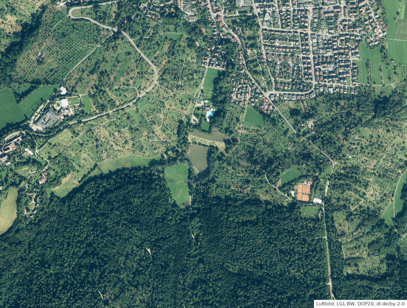
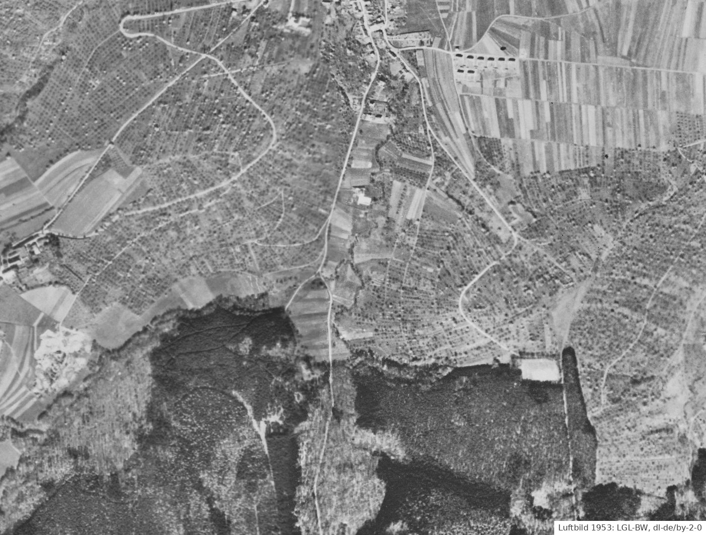
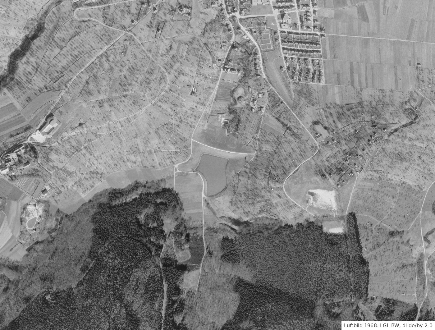
The reservoir, too, has a permanent pool: a lake that is always full and is used as a fish pond. For flood protection only the room above it counts. We recalculated it from the terrain model: if the water rises from the permanent pool at about 261.4 metres by a good nine metres to about 271 metres, the basin holds about 450,000 cubic metres. That matches the official figure of 452,000 cubic metres.
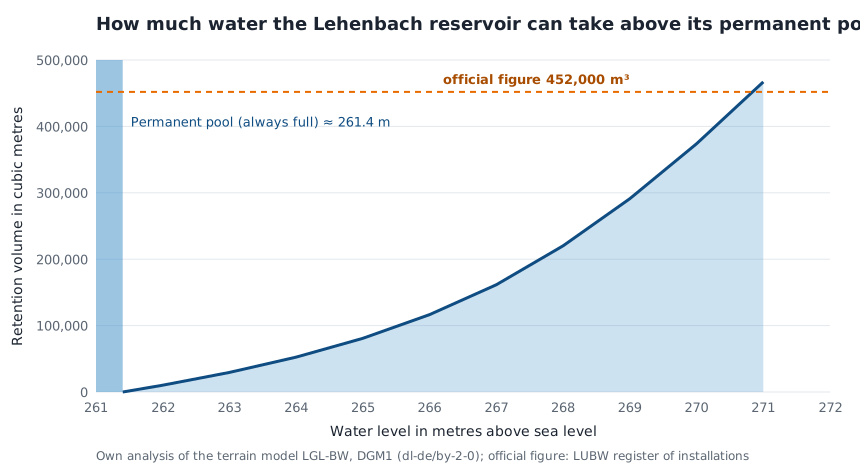
How to read the chart: The bottom axis shows how high the water rises in the basin, the left axis how much it then holds back. The narrow blue bar on the left is the permanent pool – this water is always there and does not count. The curve rises slowly at first and then ever more steeply, because the valley widens towards the top: the first metre and a half above the permanent pool holds only about 30,000 cubic metres, the two metres between 269 and 271 metres about 175,000. The dashed line is the official figure.
A comparison shows how much that is: heavy rain of 40 litres per square metre brings about 230,000 cubic metres to the 5.8 square kilometres above the dam. The basin can take it if it is empty beforehand. Below the dam, however, the water no longer runs through the lake. → Heavy rain in Winterbach
Compensation: building in the flood zone
Whoever builds in a flood plain takes room away from the river. The German Water Resources Act (§ 78) therefore requires compensation – as the Rems-Murr district office puts it, equal "in volume, function and time": just as much room, in a place where it works just the same during a flood, and at the same time. The compensation must already exist when building starts.
So that not every builder has to dig a basin, municipalities in Baden-Württemberg can keep a flood protection register (§ 65 of the state Water Act). It works like an account: the municipality creates retention space in advance – a flood hollow, an excavation, a floodplain that may flood again – records the volume in the register, and whoever builds debits the cubic metres needed – and pays for them: they reimburse the municipality for their share of what the retention space cost. So the compensation is not free, and it really is created – just pooled and in advance, where it works best. Rudersberg in the Wieslauf valley, for example, has a statute for it. Only measures created after 22 December 2013 can be counted.
Our survey of the basins leads to a simple rule for any compensation: it only works with the room that is still empty during a flood. An excavation that fills with groundwater is a nice pond – but already full during a flood. A shallow hollow that lies dry at normal water levels and only fills during a flood, on the other hand, holds back every cubic metre it was built for. It is the same difference as between a storage cistern and a retention cistern.
Flood lines can also shift: according to the explanatory statement on the "Riedwiesen" development plan, the 100-year flood line there moved north in 2020 because the Urbach-Plüderhausen retention basin went into operation – what is held back upstream does not arrive downstream.
Small basins, small effect – and still important
The catch basin by the railway underpass (G) was dry during the laser survey and can take about 250 cubic metres. According to the terrain model, hardly any water flows to it over the surface: the railway embankment, the sports grounds and the road shield it. If it has a task, it probably gets its water through a pipe or a ditch – for example from the drainage of the road or the underpass. That cannot be seen in the terrain model; we will take a look on site.
The basin by the forest sports ground (F) was full when measured. We do not know what it was built for – a fire-fighting pond, a biotope or retention are all conceivable. The Weihersee (C) is a pond in a park. And the ponds by the reservoir (E) are above all one thing: habitat.
For comparison: a thunderstorm with 30 millimetres brings 30,000 cubic metres to one square kilometre. Small basins like G take a fraction of that. What works across the landscape is the soil – meadows, forest, orchards and gardens that let rain soak in. → Sponge landscape Winterbach
Frequently asked questions
What is the Uetz gravel lake?
A gravel-pit lake by the Rems east of the Remswehr, a former gravel pit of the Uetz road-building company. Its water level is level with the Rems; during a flood it is therefore already full and holds back hardly any additional water.
Does the Lehenbach reservoir hold back every heavy rain?
It holds about 452,000 cubic metres above its permanent pool – enough for heavy rain of 40 litres per square metre on its catchment if it is empty beforehand. It does not help the area below the dam, that is large parts of the village.
Why does a full lake not count as retention?
Because water can only go where there is room. A lake fed by groundwater or permanently full has only the room above its water level during a flood – no more than a meadow in the same place.
What is a flood protection register?
An account on which a municipality books retention space created in advance. Whoever builds in a flood plain can debit the necessary compensation from it and refunds a share of the costs (§ 65 Water Act of Baden-Württemberg).
Why are the sewage-works tanks not shown?
Because they are technical installations that clean waste water. They are always full and are not there for flood retention.
Sources: State Office for Geoinformation and Land Development Baden-Württemberg (LGL-BW, 2026), digital terrain models DGM1 and DGM025, aerial photos 1953, 1968 and DOP20 (Data licence Germany – attribution 2.0); own analysis · Water bodies: © OpenStreetMap contributors (ODbL), queried 14.10.2026 · Flood hazard maps: LUBW · LUBW, register of installations (Lehenbach reservoir, 452,000 m³) · Rems-Murr district office, environmental protection department, leaflet "Bauen im Überschwemmungsgebiet" (as of 30.04.2020) · State of Baden-Württemberg, FAQ "Bauen im Überschwemmungsgebiet" (February 2019) · Municipality of Rudersberg, statute on keeping a flood protection register (2019) · Municipality of Winterbach, explanatory statement on the "Riedwiesen" development plan · → Flood protection on the Rems
Last updated: 15 October 2026 · Initiative Remswelle