
Rems and Winterbach · River, water, nature and history
The Rems through time
The Rems in the Rems valley has been a working river for centuries. It drove mills, carried firewood to Ludwigsburg until 1862, was straightened and embanked after devastating floods and today, between Winterbach and Remshalden, has been restored again. If you want to understand why the Rems at Winterbach looks the way it does – with reinforced banks, embankments, weirs and new floodplains – you will find the answer in this history.
Timber floating: firewood for Ludwigsburg
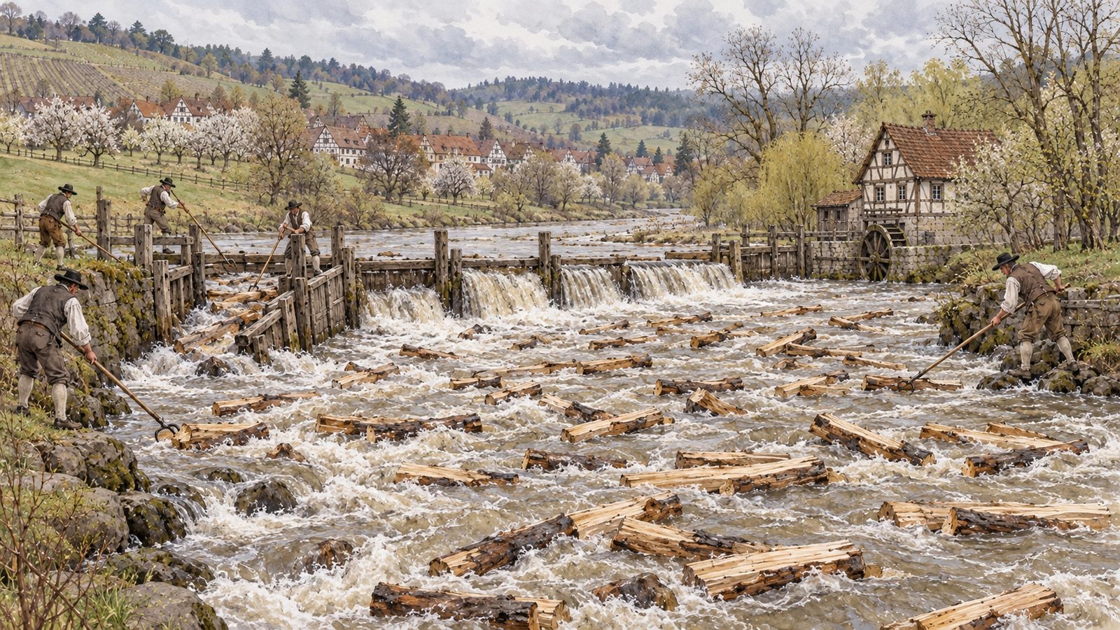
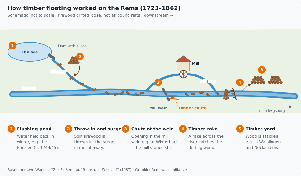
Few people today know that timber was floated down the small Rems. It was not done with bound rafts as on the Neckar but as a log drive (Trift): the firewood was thrown loose into the water in split billets and drifted downstream with the current. As early as 1627 the mill regulations required the river to be made passable for floating timber; for a long time the mill weirs prevented this. With the construction of the Ludwigsburg residence from 1715 the court needed wood, and from 1723 mainly split firewood from the Schorndorf forest was floated down the Rems. To have enough water for this, flushing ponds were created on the tributaries – the most important is the Ebnisee in Welzheim Forest, created around 1744/45. Timber chutes were built at the weirs, among other places at Winterbach, Schorndorf, Plüderhausen, Waldhausen and Großheppach; the chroniclers also mention "shallows near Winterbach". The millers in Schorndorf demanded compensation because their mills stood idle for six days and longer during the floating. With the Rems railway, which opened in July 1861, the wood travelled faster by rail; the last timber was floated in 1862. The wood was caught at timber rakes and stacked in timber yards, among other places in Waiblingen and Neckarrems.
The whole story – timber drift, flushing ponds, the Winterbach rafting chute and the question of the first Rems surfer – now has its own series: → The forgotten wave of Winterbach
Mills and hydropower
Since the Middle Ages the Rems has above all driven mills. The 1851 description of the Oberamt (district) of Schorndorf lists for Winterbach "a very significant grain and gypsum mill on a Rems canal" and a further grain mill; at that time five stone bridges crossed the Rems, the mill race and the Lehenbach (then spelt “Lehnenbach”). In Schorndorf a canal of the Rems drove several mills, and in Weiler there were a grain mill, a hammer mill and a sawmill on the Weilerbach.
Many of these mills became hydropower plants. Today about ten small installations of 30 to 150 kilowatts each operate on the Rems, among other places in Plüderhausen, Urbach, Remshalden-Grunbach, at the Birkelwehr in Weinstadt and at several mills in Waiblingen. Their weirs are still the biggest obstacles for fish. → Weirs and fish passage
Floods: a long history
The Rems is a river with moods. In the flood of March 1684, according to the Oberamt description, "nearly 40 houses were almost entirely destroyed" in Winterbach. Schorndorf recorded water damage in 1773 and 1809. At the Hahn'sche Mühle in Waiblingen, flood marks recall 1663, 1824, 1827, 1862, 1889, 1893, 1919, 1920 and 1956. On Christmas Eve 1919 the Rems in Waiblingen stood 3.60 metres above normal, higher than at any time since 1882; 85 buildings were flooded. The Schorndorf gauge has measured discharge since 1931 – the largest flood since then was that of 3 March 1956. → The Rems in figures
Straightened and embanked
For a long time the answer to floods was engineering: the Rems was straightened, its banks reinforced, embankments built. In Waiblingen the river correction began in 1865 and was intensified after the 1919 flood. Between Winterbach and Remshalden, too, the Rems flowed in a straight trapezoidal channel between dykes until 2018. Looking back, the Rems Water Board (Wasserverband Rems) notes that this strategy – carrying the Rems away faster by straightening and protective embankments – actually made the situation worse downstream. After the 1990 flood the approach therefore shifted to retention instead of acceleration: to basins that hold back the water during floods. → Flood protection on the Rems
The Rems in Winterbach: corrected and given back
In Winterbach, too, the Rems was never a calm river. "Die Rems tritt auch hier häufig aus, daher die Ufer öftere Unterhaltungskosten erfordern" (the Rems often overflows here too, so the banks frequently require maintenance costs), the Oberamt description noted in 1851. The Württemberg cadastral map (Flurkarte) of 1832 for Weiler and Winterbach shows how strongly the river shaped life in the valley. It names fields such as Altlachen and Riedwiesen, which point to wet meadows and pools of water, and Mühlbachäcker, Wehräcker and Wehrwäsle, which recall the mill race and the mill weir.
In the 20th century the Rems between Winterbach and Remshalden was engineered. The Stuttgart Regional Council (Regierungspräsidium) speaks of river corrections in the 1930s and 1950s; after that the river flowed in a straight trapezoidal channel with reinforced banks. In 2005 the Schorndorf/Winterbach flood retention basin above the village went into operation, and in 2018 the section below Winterbach was restored over 1.1 kilometres. → Restoration at Winterbach · → Springs and hillside water
→ Time travel: the historic course of the Rems at Winterbach
Bathing in the Rems
People used to bathe in the Rems. In Schorndorf in the 1920s men and women bathed together on the unsecured riverbank – much to the displeasure of many citizens. In May 1929 the town council decided on a bathing establishment at the Altlache, right on the Rems; 1,754 residents signed a petition against the mixed bathing establishment. The mayor justified the construction by the danger to children on the unsecured bank. Today the Rems is no longer a bathing water, and the health office advises against bathing. → Water quality of the Rems
The Rems returns: garden show and restoration
With the Remstal Garden Show 2019 the river moved back into the centre of the towns and villages. In many places the Rems was restored, banks flattened and access points to the water built. In Winterbach a stepped access to the Rems was created below the Gleisdorfer Platz; between Winterbach and Remshalden the Rems was freed from its trapezoidal channel over 1.1 kilometres in 2018, and the side streams were reconnected to the river via rough ramps. In Weinstadt-Großheppach a Rems beach with a shallow-water zone was created. → Restoration at Winterbach
What this means for the Remswelle
The Rems was never an untouched river. It has always been used – for mills, wood, energy, flood protection – and in recent years a part of it has been given back. A wave would be a new use at a place that has long been shaped by engineering: at the outlet structure of a retention basin. Precisely for that reason it must be measured against what counts today: flood protection, fish passage and a river where people like to be. → The Winterbach site
Frequently asked questions
Was timber floated on the Rems?
Yes, though as a log drive with loose wood, not with bound rafts. From 1723 mainly split firewood from the Schorndorf forest was floated for Ludwigsburg, with timber chutes among other places at Winterbach and Schorndorf. The railway along the Rems brought timber floating to an end; the last took place in 1862. → The forgotten wave of Winterbach
What was the Ebnisee created for?
As a flushing pond for timber floating on the Wieslauf and Rems, around 1744/45. Its water was released so there was enough water to carry the loose wood downstream.
Why is the Rems so straight?
Because from the 19th century onwards it was straightened and embanked for flood protection, in Waiblingen from about 1865. Since the Remstal Garden Show 2019 individual sections have been restored again.
When was the worst flood in Winterbach?
The flood of March 1684 is recorded, in which nearly 40 houses were destroyed. Since measurements began in 1931, the largest flood was that of March 1956.
Sources: Beschreibung des Oberamts Schorndorf (description of the Oberamt of Schorndorf), ed. by the Königlich statistisch-topographisches Bureau, Stuttgart 1851 (Wikisource), chapters B 1 (Schorndorf), B 26 (Weiler), B 27 (Winterbach) · Uwe Wandel, "Zur Flößerei auf Rems und Wieslauf", Waiblingen in Vergangenheit und Gegenwart vol. 9 (1987), Heimatverein Waiblingen · Wikipedia, "Rems" (history of use, hydropower plants; accessed 26.09.2026) · Haus der Stadtgeschichte Waiblingen, online exhibition "Als Weihnachten ins Wasser fiel. Remshochwasser 1919" · Zeitungsverlag Waiblingen: 06.07.2024 (Rems correction Waiblingen), 31.08.2018 (Schorndorf open-air pool 1929), 21.08.2018 (access to the Rems, Winterbach), 19.03.2018 (Rems beach Großheppach) · Wasserverband Rems, "Geschichte des Verbands" · Regierungspräsidium Stuttgart, "Die Rems fließt wieder", 19.12.2018 · Wikipedia, "Remstal Gartenschau 2019" · Landesarchiv Baden-Württemberg, Staatsarchiv Ludwigsburg EL 68 VI Nr 2356, Flurkarte NO XXVIII 29 (cadastral map), as of 1832 (Weiler, Winterbach), via LEO-BW · Wikipedia, "Hochwasserrückhaltebecken Schorndorf-Winterbach" · Plaque „Remsmühle“ on the former Rems mill, Winterbach (photographed 28.09.2026)
Last updated: 15 October 2026 · Initiative Remswelle