
Rems and Winterbach · River, water, nature and history
One valley, two directions
Did the Rems once flow to the Danube?
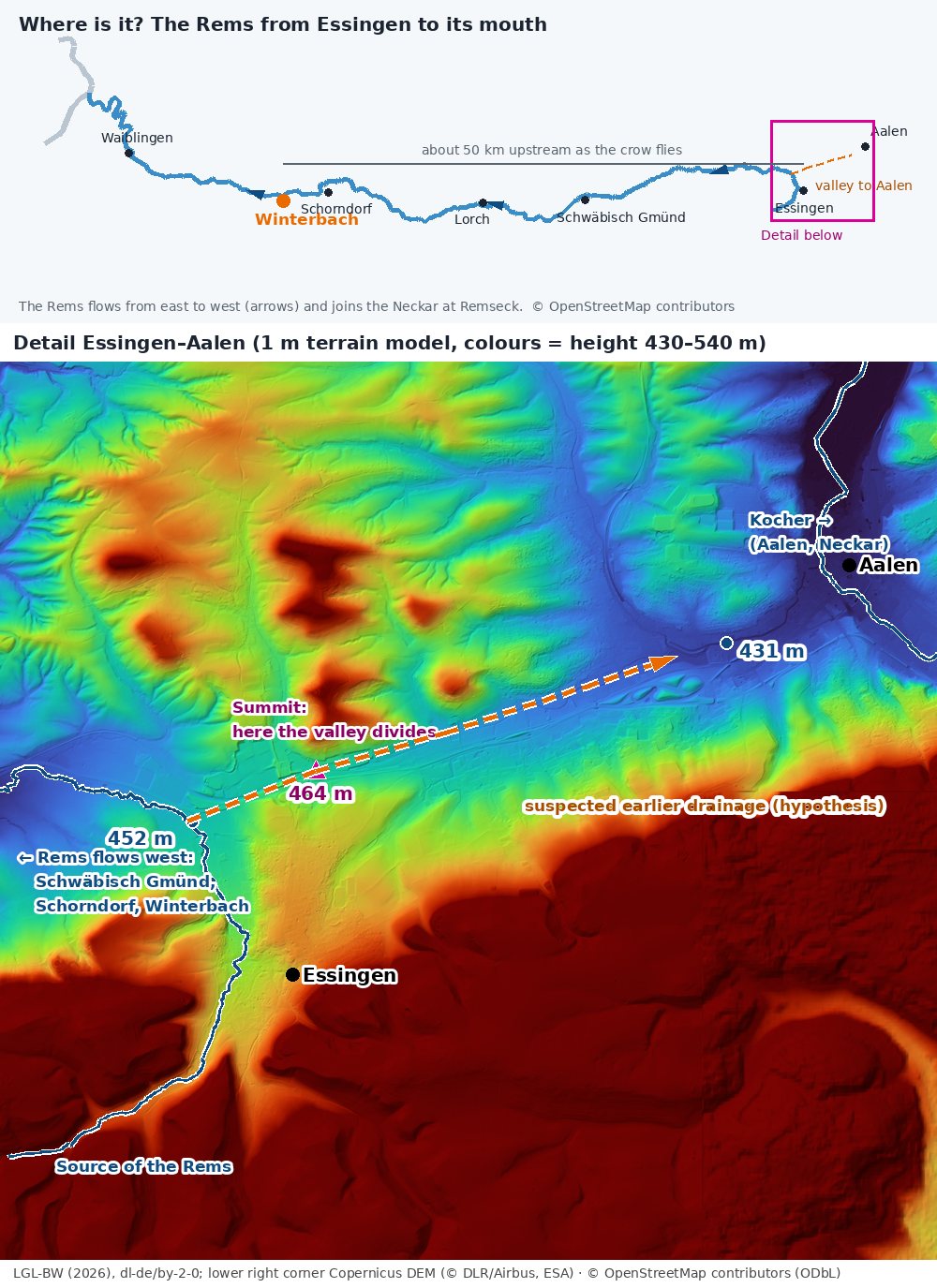
"Why doesn't the Rems flow the other way round?" – Anna asked this question, and it would not let us go. At Winterbach today's valley shows no trace of a reverse direction – the Rems dug it itself, flowing west. Long before that, though, things looked very different here (more below). The most exciting trace lies about 50 kilometres upstream, near Essingen at the edge of the Swabian Jura. There the terrain shows something remarkable: a valley that drains in two directions.
The bend near Essingen
The Rems rises south-west of Essingen. From there it first flows about three kilometres north-east – straight towards Aalen. Then it bends sharply and flows west, past Mögglingen and Schwäbisch Gmünd all the way to us in Winterbach. A river that first runs one way and then almost turns back: geologists call this an elbow.
One valley, two directions
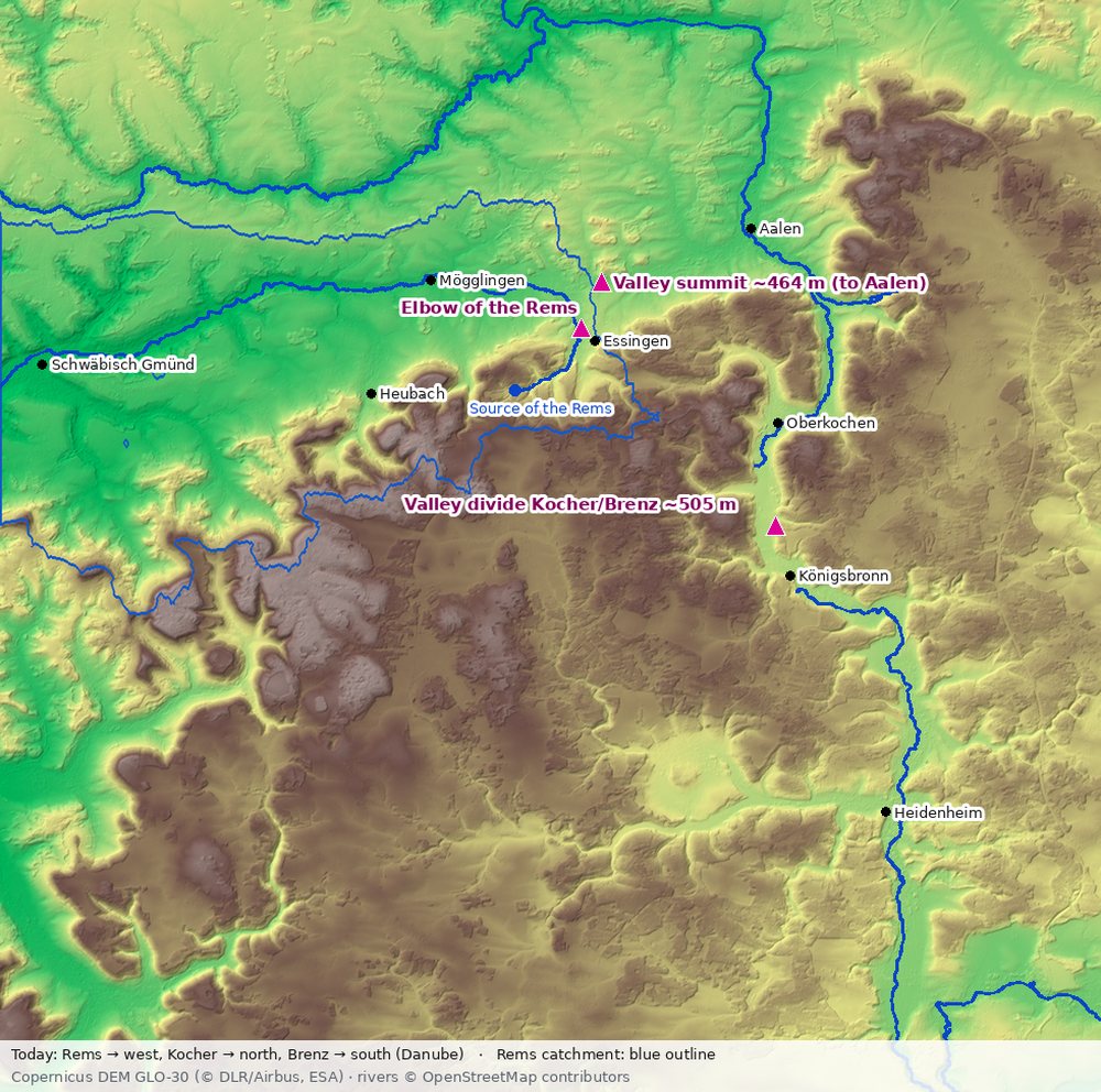
Where the Rems makes its bend, it lies in a broad valley running west–east – about seven kilometres long, from Mögglingen to Aalen. The state's terrain model with one-metre resolution shows: the valley floor rises evenly from the Rems side to a flat summit at about 464 metres and then falls just as evenly to the Kocher in Aalen, which flows at about 431 metres. Where the Rems comes into this valley from Essingen and turns west, it lies at about 452 metres – so the summit towards Aalen is only about twelve metres higher and a little over a kilometre away. West of it the water flows to the Rems, east of it to the Kocher.
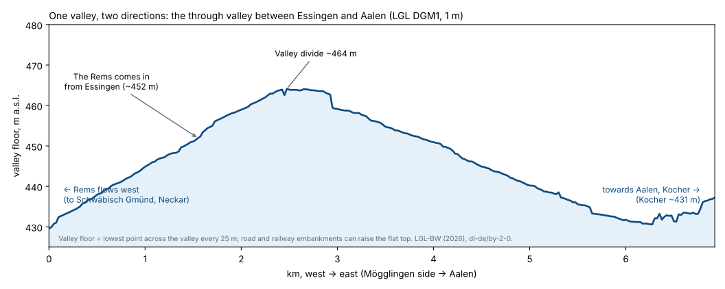
How to read the chart: Every 25 metres we went across the valley in the terrain model and looked for the lowest point – that is the valley floor. The Rems side is on the left, Aalen on the right. The line rises from the left, reaches a broad, flat ridge in the middle and falls again to the right. Where the Rems comes into the valley from Essingen in the south, it lies only about twelve metres below this ridge. Roads and the railway run through the valley; their embankments can raise the flat summit a little.
This is called a valley divide: a continuous, broad valley that today drains in two directions from a barely visible threshold. The small streams that flow in it today did not dig a valley this wide. It looks like the bed of a river that once flowed straight through.
How such valleys form
Valley divides typically form through river capture. A river with a steep gradient eats its way further and further back into the landscape with its upper course – geologists speak of headward erosion. If it meets the valley of another, slower river, it captures it: the water upstream suddenly takes the steeper, shorter route. Three traces are left behind that you can recognise in the terrain:
- an elbow where the captured river turns off today,
- a broad valley without a matching river on the other side – the old bed, in which only small streams flow now,
- a flat summit in the valley floor, where the water divides today.
These are exactly the three traces we see near Essingen. Close by there is a famous, well-researched example of the same kind: the broad valley between Oberkochen and Königsbronn, in which the Kocher now flows north and the Brenz south – separated by a "flat, barely recognisable valley divide".
What geology knows about the Urbrenz
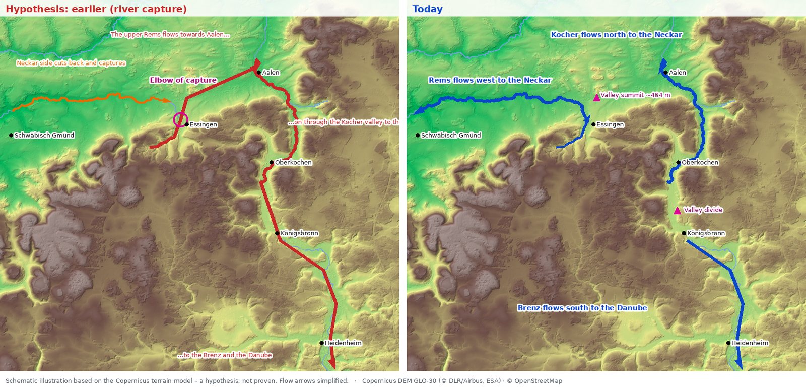
Today's Brenz rises in the Brenztopf spring in Königsbronn. It is, as the geologists Winfried Reiff and Theo Simon write, the modest remnant of a large river, the Urbrenz, whose headwaters in the geological past rose 80 to 90 km further north. Its catchment included large parts of today's upper catchments of the Rems, Kocher and Jagst; the water ran to the gap in the Jura escarpment at Aalen and from there through the Swabian Jura to the Danube. The evidence: quartz sands and pebbles on the heights along the Brenz valley and the Goldshöfe sands near Hüttlingen, deposited by a river system draining south to the Brenz.
Then the rivers on the Neckar side won: they have a much shorter way to the sea and therefore more gradient – so they cut down faster. In the Pleistocene, several hundred thousand years ago, according to Reiff and Simon the Urbrenz was captured by headward erosion of the eastern tributaries of the Neckar – above all the Kocher and Jagst, to a lesser extent the Rems and Murr – and diverted towards the Rhine at Aalen. The town of Oberkochen sums it up: the reversal came from the steeper gradient of the Rhine and Neckar and their tributaries (Jagst, Kocher, Rems).
And at Winterbach?
In today's valley at Winterbach we find no such trace. We checked in the terrain model how the streams join the Rems: all the larger tributaries – Lehenbach, Krebsbach, Brunnbach, Schweinbach, Wieslauf – come in "with the current", at an angle in the direction of flow. Had the Rems once flowed the other way here, some of them would join against the current. The broad valley at Winterbach has a different explanation: here the Rems flows through soft Gipskeuper marl, which it could easily clear away. → When this was sea
It was quite different long before this valley existed. On a geologists' map of the river system in the early Miocene, around 20 million years ago, even the proto-Neckar flows south at Stuttgart and then east as the "Urlone" to the Danube; the edge of the Swabian Jura lies roughly at the level of today's Rems valley (Reiff and Simon 1990, after Simon 1988). So the water from our area ran east at that time – just not in a Rems valley: that did not exist yet, the land surface lay much higher than today's valley floor. Only as the Neckar side ate its way further and further east did today's Rems valley form, and the Rems dug it out flowing west.
What this means for the Remswelle
Near Essingen, twelve metres of terrain decide whether a raindrop flows to the North Sea or the Black Sea. On a large scale this shows what holds for the wave on a small scale: the landscape decides which water arrives in the Rems – how much and how evenly. The catchment of the Rems is fixed today; what we can influence is how long the landscape within it holds the water. → More flow for the Rems · → Reading the landscape
Frequently asked questions
Did the Rems once flow to the Danube?
Its uppermost part near Essingen probably did: it lay in the catchment of the Urbrenz, which flowed via Aalen to the Danube before the Neckar side captured the system. The terrain near Essingen fits this. For the Rems in detail it is not proven.
Did the Rems at Winterbach flow the other way?
Not in today's valley: the westward-flowing Rems dug it itself, and the tributaries show no sign of a reverse direction. Long before that, in the Miocene, the water of this area flowed east to the Danube according to geologists' maps – but the Rems valley did not exist then.
What is a valley divide?
A watershed that does not lie on a ridge but in the middle of a valley. The water flows away in two directions from a barely visible threshold in the valley floor. Valley divides are typical traces of river capture.
When was the Urbrenz diverted?
In the Pleistocene – according to Reiff and Simon in the Mindel glaciation or shortly afterwards; other accounts give an older age. That is why we write "several hundred thousand years ago".
Could the Rems be made to flow to Aalen again?
Technically the threshold is low. But diverting water from one river into another is no option, legally or ecologically – and it would do nothing for the wave, because the catchment above Essingen is small.
Sources: Winfried Reiff and Theo Simon, "Die Flußgeschichte der Urbrenz und ihrer Hauptquellflüsse", Jahresberichte und Mitteilungen des Oberrheinischen Geologischen Vereins 72 (1990), pp. 209–225 · Theo Simon, "Karten zur Landschaftsgeschichte in Baden-Württemberg", in: LGRB-Informationen 25 (2011) · Wikipedia (German), "Urbrenz" (with further literature) · Town of Oberkochen, "Europäische Wasserscheide" · LGRB, "Goldshöfe-Sande – Ostalb" · Own analysis: digital terrain model DGM1, LGL-BW (2026), dl-de/by-2-0; Copernicus DEM GLO-30 (© DLR e.V. 2010–2014 and © Airbus Defence and Space GmbH 2014–2018, provided under COPERNICUS by the European Union and ESA); waters © OpenStreetMap contributors (ODbL) · Graphics: Remswelle initiative
Last updated: 15 October 2026 · Initiative Remswelle