
Rems and Winterbach · River, water, nature and history
Where the water comes from: the tributaries of the Rems
By Winterbach the Rems has taken in a good two dozen streams, most of them only a few kilometres long. The largest contributions come from the Wieslauf from Welzheim Forest, which joins shortly before Schorndorf, and the Strümpfelbach, which joins in Schwäbisch Gmünd. At the Schorndorf gauge, just under two kilometres above the "Remswehr" (as it is called locally), the Rems drains 418 square kilometres. What is measured there as discharge is the sum from this whole area – and exactly this amount of water is what a wave in Winterbach would have available.
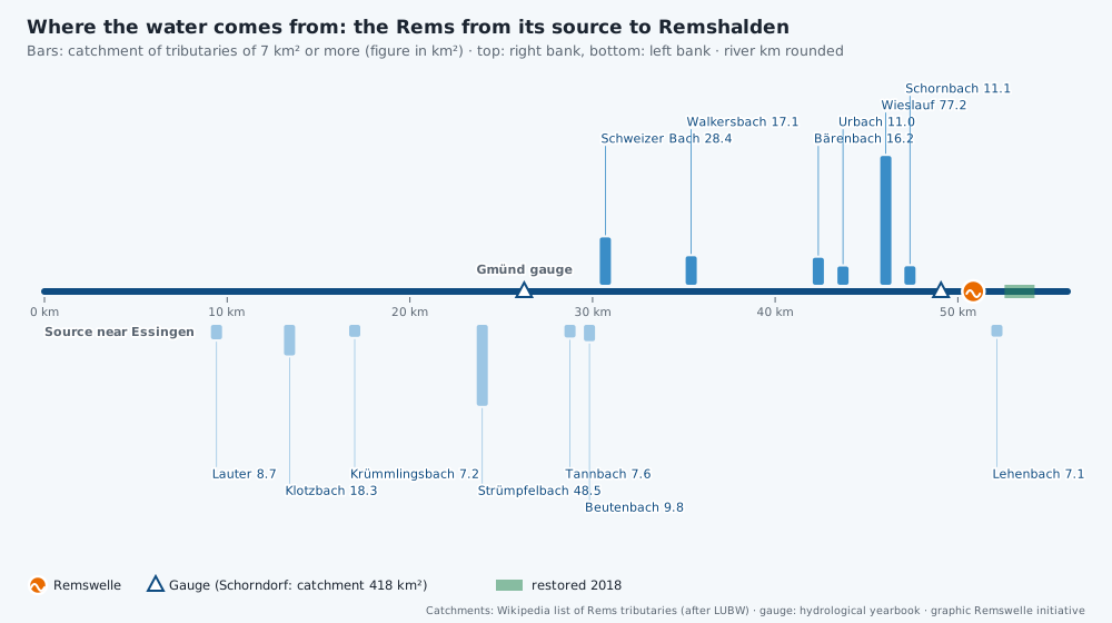
The course of the Rems to Winterbach
The Rems rises about three kilometres south-west of Essingen in a karst spring, the Remsursprung, at about 551 metres. It first flows briefly north, then west: through Mögglingen, Böbingen and Schwäbisch Gmünd, on to Lorch, Plüderhausen, Urbach and Schorndorf. From the right, from Welzheim Forest, come the longer streams: Schweizerbach, Walkersbach, Bärenbach, Urbach, Wieslauf and Schornbach. From the left, from the edge of the Swabian Jura and from the Schurwald, the Lauter, Klotzbach, Strümpfelbach, Tannbach and Beutenbach join. In Winterbach itself most streams come from the left out of the Schurwald, the Krebsbach from the right. → Map of the whole Rems
The larger tributaries down to Winterbach
| Tributary | Bank | Confluence | Length | Catchment |
|---|---|---|---|---|
| Lauter | left | opposite Mögglingen station | 5.1 km | 8.7 km² |
| Klotzbach | left | Böbingen | 9.0 km | 18.3 km² |
| Krümmlingsbach | left | Schwäbisch Gmünd-Zimmern | 5.3 km | 7.2 km² |
| Strümpfelbach (in its lower course Waldstetter Bach, Josefsbach) | left | north-western tip of Gmünd's old town | 13.2 km | 48.5 km² |
| Tannbach | left | near the Sachsenhof (Gmünd-Großdeinbach) | 4.6 km | 7.6 km² |
| Beutenbach | left | Reichenfeld near Lorch | 6.3 km | 9.8 km² |
| Schweizerbach | right | Lorch, opposite the sports ground | 10.8 km | 28.4 km² |
| Walkersbach | right | after the Lorch gravel-pit lakes | 8.4 km | 17.1 km² |
| Bärenbach | right | Plüderhausen | 8.0 km | 16.2 km² |
| Urbach | right | Urbach, near the Rems railway bridge | 8.6 km | 11.0 km² |
| Wieslauf | right | shortly before Schorndorf, near the Wieslauftalbahn bridge | 23.7 km | 77.2 km² |
| Schornbach | right | Schorndorf | 6.6 km | 11.1 km² |
The table lists the tributaries with a catchment of about seven square kilometres or more. The complete list with over fifty streams down to Remshalden is given by Wikipedia; its figures are based on LUBW watercourse data. We have not yet checked them ourselves against the original data.
The Wieslauf – the most important tributary for the wave
The Wieslauf rises near Kaisersbach, flows through Welzheim Forest, past the Ebnisee, through Rudersberg, Miedelsbach and Haubersbronn and joins the Rems shortly before Schorndorf – about four kilometres above the Ostlandstraße bridge. With 77 square kilometres it brings by far the largest catchment. On the Wieslauf, the Flood Forecasting Centre (HVZ) operates a gauge of its own at Haubersbronn. When it rains heavily in Welzheim Forest, the Rems at Schorndorf therefore rises even when Schwäbisch Gmünd is still calm.
The streams in Winterbach
Within Winterbach, smaller streams join, most of them from the south out of the Schurwald, the Krebsbach and the Höffenklinge from the north. Above the bridge the Weilerbach joins (called Brunnbach in its upper course), and from the north the water of the Höffenklinge on the Hungerberg – a small wooded ravine (Klinge) with field copse, dry-stone wall and lean hay meadows that are recorded in the biotope survey of the state. Below follow the Lehenbach (4.9 km, 7.1 km²), which runs culverted under the main road through the village, the Krebsbach with the Wattenbach, culverted under Lederstraße, the Bücklensweilerbach (Mönchsklingenbach in its upper course) after the treatment plant, the Alsebach and, on the boundary with Remshalden, the Schweinbach. They play no role for the amount of water available to the wave, because they join below the site. For flood and heavy-rain protection in the village, however, they are all the more important. → Flood protection on the Rems
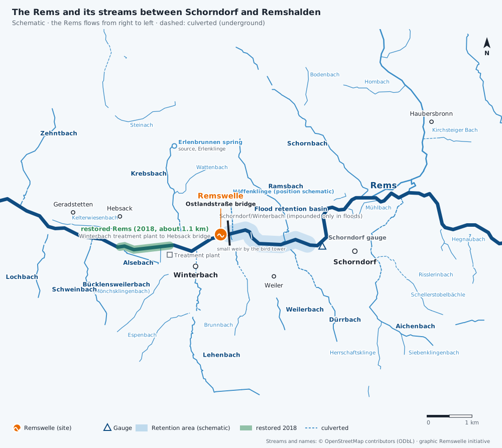
The water map lets you look at the streams in Winterbach one by one – tap for the name; culverted sections are dashed.
Streams under the road: what "culverted" means
Several streams in Winterbach run underground for part of their course, in a pipe or channel beneath roads and buildings. In German this is called "verdolt" – culverted. According to OpenStreetMap map data, this applies to about 240 metres of the Lehenbach beneath the main road through the village, about 170 metres of the Krebsbach beneath Lederstraße, about 80 metres of the Espenbach and a few dozen metres of the Weilerbach with the Brunnbach. These are approximate values from the map, not official lengths.
Streams were culverted in many places where space was needed in the village for roads, paths and buildings – the stream disappeared from view. For animals such a section is a dark, uniform channel without banks or plants: fish and small organisms find hardly any habitat there, and longer pipes can interrupt the passability of the stream. In heavy rain, culverts are also sensitive points. The Bavarian Environment Agency calls culverts "particular danger points along the watercourse" because branches and debris can get caught at the inlet – experts call this blockage (Verklausung). That is why it matters to keep inlets and the stream above them clear. Where water collects in the village during extreme rainfall is shown by the municipality's heavy-rain hazard maps.
Today the trend runs in the other direction. Since a ruling by the Administrative Court of Baden-Württemberg in 1994, new culverts are generally no longer permitted in the state. The guideline of the State Institute for the Environment (LUBW) recommends opening culverts "as far as possible" or at least redesigning them ecologically – for example with a natural bed or light shafts. Where renovation is due anyway, it should be checked whether an open stream is possible; according to the guideline this often also improves discharge capacity and flood protection. Whether that works at a particular spot depends on space, utility lines and buildings, and is a question for the experts. Our aim here is to explain what lies behind the word – and why the small streams in the village are more than a pipe. → Flood protection on the Rems · → Springs and hillside water
The gauges on the Rems
The Flood Forecasting Centre Baden-Württemberg (HVZ) publishes, among others, the Schwäbisch Gmünd, Schorndorf, Schorndorf-Bauhof and Neustadt gauges on the Rems and the Haubersbronn gauge on the Wieslauf. For Winterbach, Schorndorf is the relevant one: according to the map data the gauge lies above the "Remswehr" and below the mouth of the Wieslauf, and only small streams join in between. Our wave preview on the home page reads its values live. We use the Schwäbisch Gmünd gauge for the trend: in the 2016 flood, according to newspaper reports, the peaks in Gmünd and Schorndorf were about five hours apart. → Flow of the Rems
What this means for the Remswelle
A wave in Winterbach lives on the water of an area that stretches from the Eastern Swabian Jura (Ostalb) into Welzheim Forest. Rain in the upper Rems valley arrives in Winterbach hours later, rain in Welzheim Forest arrives faster via the Wieslauf. Conversely, in summer the small streams dry up first; in August 2026 the Rems ran dry near Mögglingen. How many days a year there is ultimately enough water for a wave is shown by the analysis of 90 years of gauge data. → Flow of the Rems
Frequently asked questions
Where does the Rems rise?
The Rems rises in the Remsursprung, a karst spring about three kilometres south-west of Essingen in the Ostalbkreis district, at an altitude of about 551 metres.
How long is the Rems?
78.4 kilometres according to Wikipedia; the municipality of Essingen gives "approx. 80 km". The Rems joins the Neckar at Neckarrems (Remseck am Neckar).
What is the largest tributary of the Rems?
Above Winterbach it is the Wieslauf, 23.7 kilometres long with a catchment of 77.2 square kilometres. It joins shortly before Schorndorf.
Which streams flow into the Rems in Winterbach?
The Weilerbach and the water of the Höffenklinge (above the Ostlandstraße bridge), then the Lehenbach, Krebsbach, Bücklensweilerbach, Alsebach and, on the boundary with Remshalden, the Schweinbach.
How large is the catchment of the Rems?
582.6 square kilometres in total, 418 square kilometres at the Schorndorf gauge.
Sources: Wikipedia, "Rems" and "Liste der Zuflüsse der Rems" (accessed 26.09.2026; data according to LUBW) · Bayerisches Landesamt für Umwelt (Bavarian Environment Agency), Arbeitshilfe "Gewässerunterhaltung innerorts" (April 2018), p. 16 · LUBW, "Durchgängigkeit für Tiere in Fließgewässern – Leitfaden Teil 4" (passability for animals in rivers, guideline part 4: culverts, piping, side waters and floodplain; 2008), pp. 7, 9, 23 · lengths of culverted sections: own analysis of map data © OpenStreetMap contributors (approximate) · Gemeinde Essingen (municipality of Essingen), "Remsursprung" · LUBW, Deutsches Gewässerkundliches Jahrbuch Rheingebiet Teil I 2009 (Schorndorf gauge) · Hochwasservorhersagezentrale Baden-Württemberg (Flood Forecasting Centre, HVZ), list of gauges · Stadt Schorndorf (town of Schorndorf), "Gewässer, Hochwasserschutz, Starkregen" · LUBW, biotope survey (service "Biotopkartierung", accessed 26.09.2026) · Remswelle initiative, local knowledge (Höffenklinge) · Zeitungsverlag Waiblingen, 02.06.2024 (Lehenbach) · Map data © OpenStreetMap contributors (ODbL)
Last updated: 15 October 2026 · Initiative Remswelle