
Rems and Winterbach · River, water, nature and history
The historic course of the Rems at Winterbach
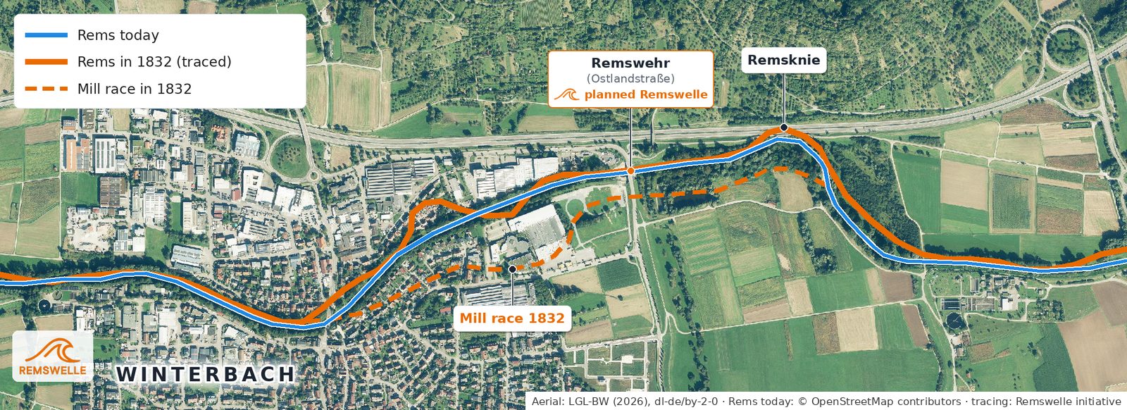
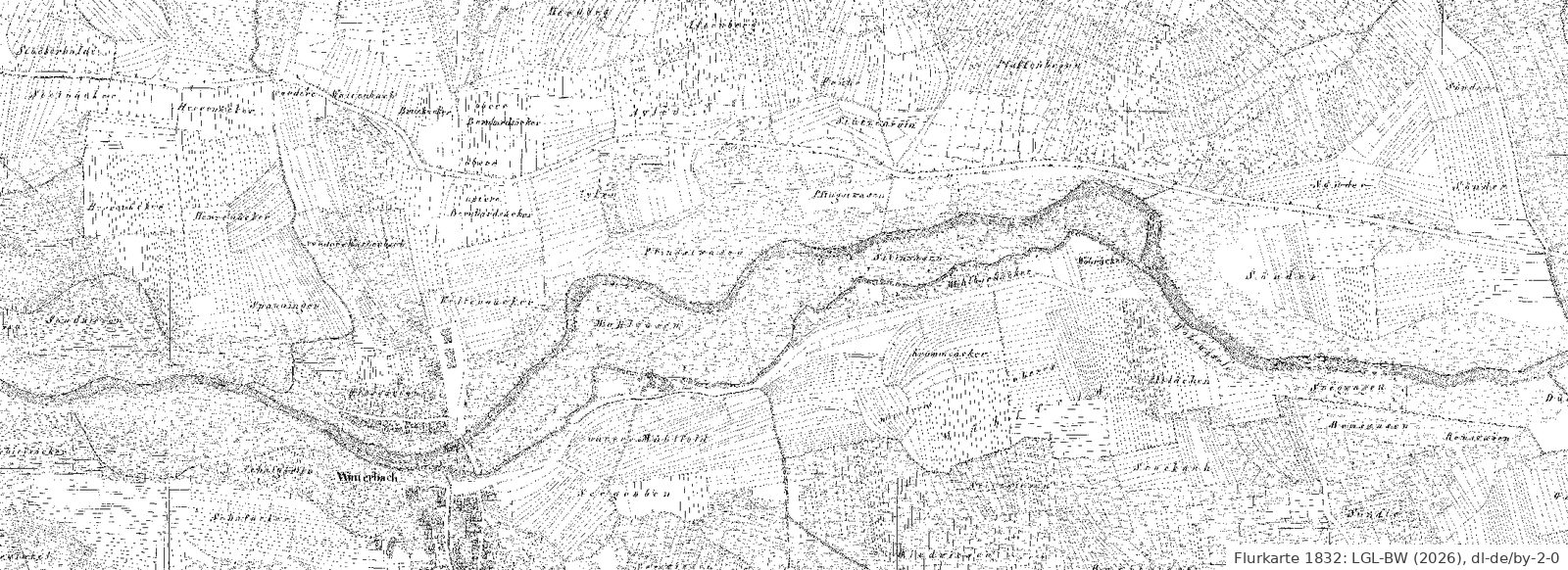
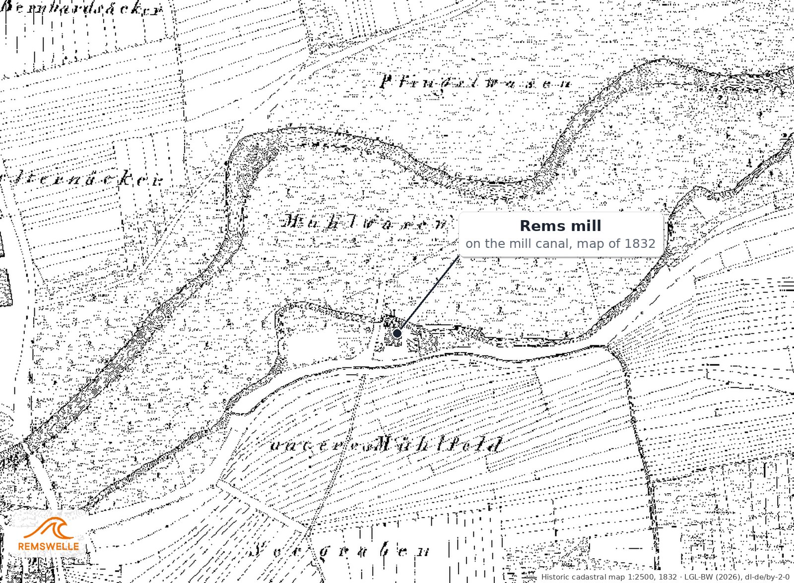
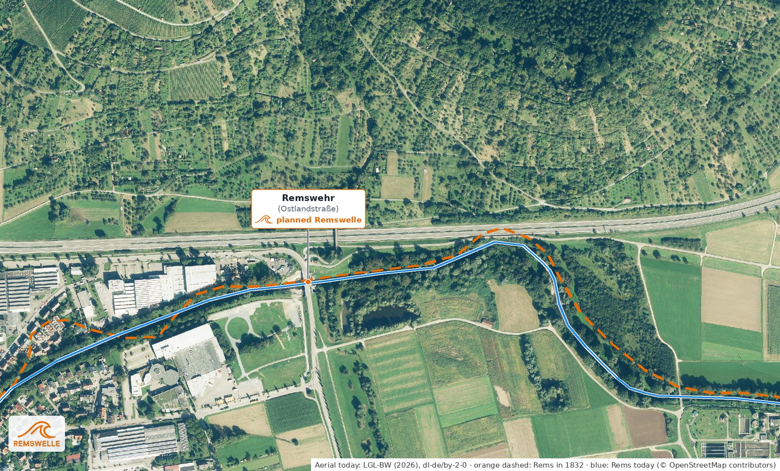
How did the Rems flow at Winterbach before it was corrected in the 1930s and 1950s? The Württemberg cadastral map of 1832 and an aerial photograph from 1968 give a vivid answer. Both are available, precisely georeferenced, from the State Office for Geoinformation and Land Development, so they can be laid exactly over an aerial photograph of today. We have traced the course of the Rems from 1832. The result: even then the Rems flowed through the same section of the valley – but with more bends, and alongside it ran a mill race that no longer exists today.
What the 1832 cadastral map shows
Below the village centre, towards Remshalden, the Rems in 1832 lay almost where it flows today, though with small bends. Above the village centre things looked different: between the village and today's Ostlandstraße bridge the river made an additional loop to the north, which is missing today. The large bend at the Remsknie already existed at that time.
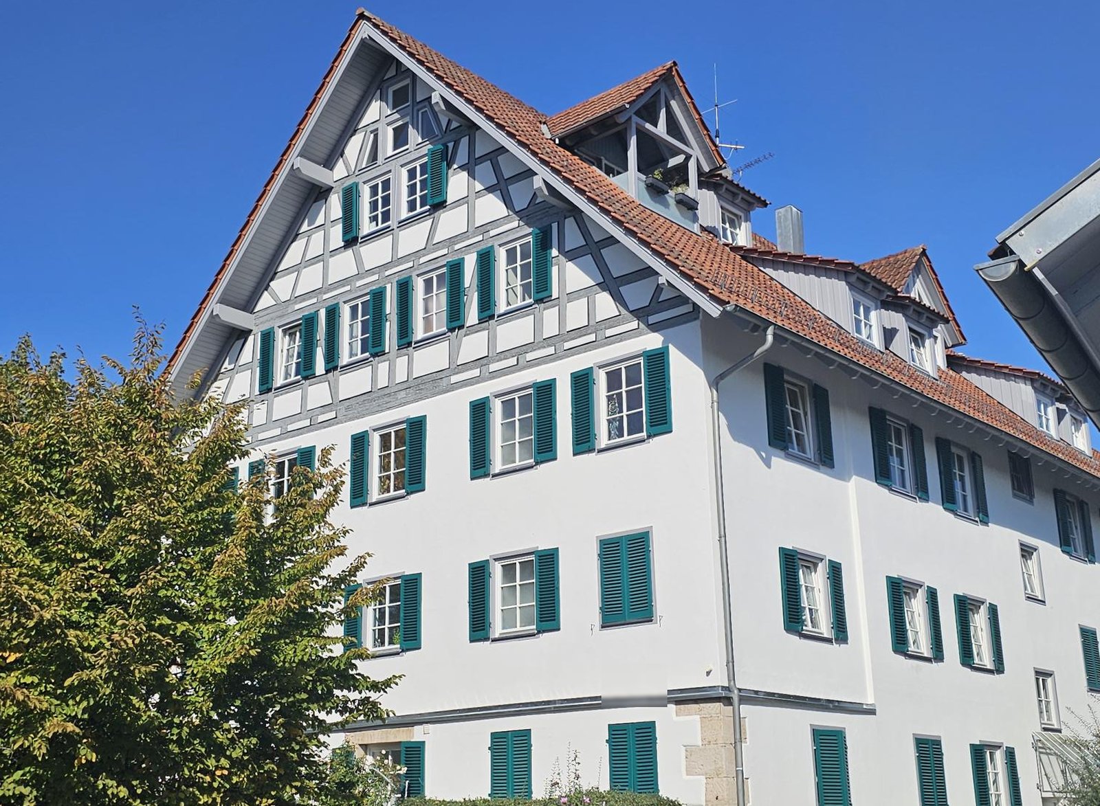
Besides the Rems, the map shows a second watercourse: the mill race. It branched off the Rems in the bend before the Remsknie – roughly where the small weir is today – ran south of the river through the meadows and flowed back into the river at the edge of the village. On it stood the mill that the 1851 Oberamt description describes as „eine sehr bedeutende Mahl- und Gyps-Mühle an einem Remskanal“ (a very significant grain and gypsum mill on a Rems canal). The field name Mühlbachäcker, which appears on the map right next to the race, recalls it. In today's aerial photograph nothing of this race can be seen any more – nor in the state's terrain model, which shows the ground to within a few centimetres: race and old river arms have been levelled and built over, the sports centre stands on the route. Unlike the old vineyard strips on the Hungerberg, the floodplain has lost its memory. → Traces in the Hungerberg → The Rems through time
1968: the Rems in a trapezoidal channel
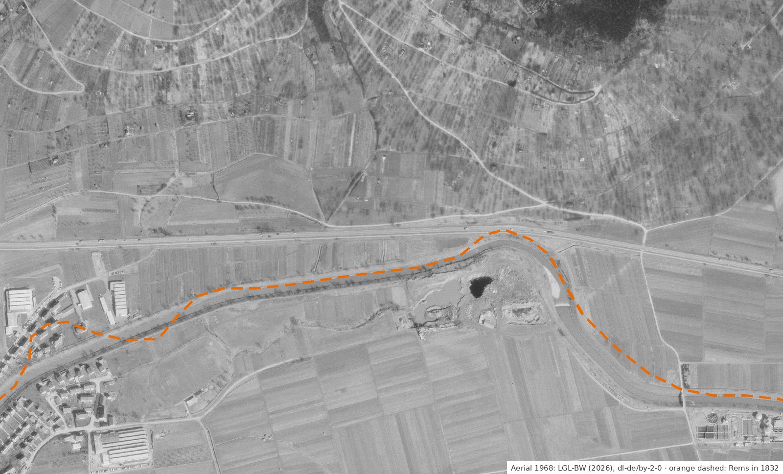
The 1968 aerial photograph shows the Rems after the river corrections: a straight channel of uniform width with embankments and wide floodplain strips, from the village centre to the Remsknie. The loop above the village centre has gone; the river runs by the shortest route. South of the river a larger pit with water can be seen. There is no bridge visible at the site of today's Ostlandstraße; the outlet structure of the flood retention basin was only built between 2002 and 2005.
What has changed – and what has not
Above all, the shape has changed: a winding river with a mill race became a straight channel intended to carry floods away faster. Today trees and shrubs line the banks, and at the Ostlandstraße bridge stands the outlet structure of the retention basin. What has stayed the same is the position in the valley: at Winterbach the Rems was not moved to a completely different place, but straightened and confined to a fixed bed. Below the village a section was restored again in 2018. → River restoration at Winterbach · → Flood protection on the Rems
Field names at the Remsknie
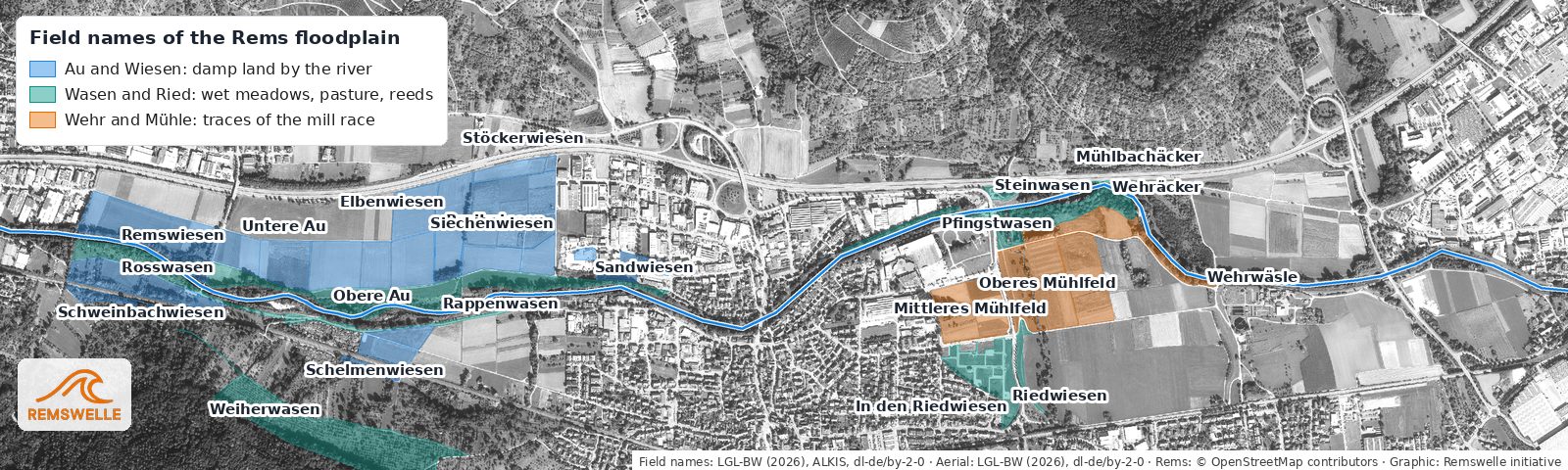
Around the Remsknie the field names in the land register still tell of the mill race: Wehräcker and Wehrwäsle (weir fields) lie where the race branched off, Mühlbachäcker and the Mittleres and Oberes Mühlfeld (mill fields) along its course. Pfingstwasen and Steinwasen on the north bank were wet pastures, the Riedwiesen further south recall reeds and marsh. The map below shows the whole floodplain down to the Hebsack bridge; we explain the names on the restoration page. → What the field names tell
Vision: bringing the mill race back to life
Vision of the initiative – not a plan. The old mill race has disappeared from the village, but its trace can still be found: from the offtake at the bird tower (Vogelturm) across the Mühlwasen meadows to the Rems mill. We would like to make it at least partly visible again. Three stages are conceivable:
- Making the trace visible. A band in the paving or lawn, a few information boards and perhaps a short stretch of channel show where the mill race ran – for example along our mill loop. This is comparatively inexpensive and needs no water. → Walks around the Remswelle
- An open water channel fed by rainwater. Instead of piping rainwater into the sewer, it could flow in an open channel along the old mill race, seep away and evaporate. This is the "sponge city" principle recommended by the German Environment Agency: the town absorbs rain, stores it and releases it slowly – which cools on hot days and buffers heavy rain. → Cool air for Winterbach
- A real channel with water from the Rems. This would be the most beautiful and at the same time the most difficult option. In summer the Rems often carries less than 1 m³/s, and its mean low-water flow is about 0.95 m³/s – any diversion needs a water-law permit and must leave enough water in the river. On top of that come flood protection, maintenance and costs. → River flow and surfable days Our dream, admittedly with a wink: after the session at the Remswehr, lie down on the board and drift comfortably back into the village along the mill race. Whether that will ever be possible, nobody knows – but at least the direction would be right.
What others have done. In Leipzig, the Elstermühlgraben, an old mill race, was largely moved underground around 1960; since 2004 the city has been reopening the almost one-kilometre underground section in stages. In Süßen in the district of Göppingen, the mill race was redesigned in a near-natural way in 2017/18: concrete walls were removed, banks and plants returned, and the channel became part of a community park. Zurich has pursued a stream concept since 1988: of the roughly 40 kilometres of open streams in its built-up area today, about half have been reopened.
What this means for the Remswelle
The site of the wave at the Ostlandstraße bridge lies where the Rems already flowed in 1832 – on a river that has been used and reshaped for generations and, most recently, partly given back. At this technically shaped location a wave would not destroy anything original, but it has to be measured against what matters today: flood protection, passage for fish and a river where people like to be. → Site Winterbach · → Springs and hillside water
How the images were made
The cadastral map and aerial photographs come from the map services of the State Office for Geoinformation and Land Development Baden-Württemberg (LGL): the historic cadastral map of Württemberg at 1:2500, whose first prints were produced between 1818 and 1840 (Winterbach sheet: as of 1832), the aerial photograph of the state survey flight of 1968 and the current digital orthophoto. All three are precisely georeferenced; we retrieved the same section for each time layer. We traced the course of the Rems and the mill race of 1832 by hand on the cadastral map and transferred them to today's aerial photograph. The data are licensed under the Datenlizenz Deutschland – Namensnennung – Version 2.0 (Data licence Germany – attribution – version 2.0).
Frequently asked questions
Was the Rems at Winterbach moved?
According to the map comparison, not to a completely different place. In 1832 it flowed in the same section of the valley, but with more bends. During the corrections in the 20th century it was straightened, a loop above the village centre disappeared, and the mill race was abandoned.
Was there a mill race in Winterbach?
Yes. The 1832 cadastral map shows a race that branched off the Rems in the bend before the Remsknie, roughly at today's small weir, and flowed back into it at the edge of the village. In 1851 a „sehr bedeutende Mahl- und Gyps-Mühle an einem Remskanal“ (very significant grain and gypsum mill on a Rems canal) is described there.
Is the small weir before the Remsknie connected with the mill race?
Probably. In 1832 the mill race branched off the Rems roughly where the small sill is today, and next to it is the field name “Wehräcker”. That the sill goes back to the old mill weir is not documented, however – it is our assessment from the map comparison.
Did the Remsknie exist earlier?
Yes, the large bend of the Rems at the Remsknie can already be seen on the 1832 cadastral map.
May the maps be used?
The LGL's maps and aerial photographs are licensed under the Datenlizenz Deutschland – Namensnennung 2.0 (Data licence Germany – attribution – version 2.0). They may be used with the credit "LGL-BW (Jahr), Datenlizenz Deutschland – Namensnennung – Version 2.0, www.lgl-bw.de" (Jahr = year).
Sources: Landesamt für Geoinformation und Landentwicklung Baden-Württemberg (State Office for Geoinformation and Land Development Baden-Württemberg, LGL-BW, 2026), WMS "Historische Flurkarte Württemberg 1:2500" (historic cadastral map; sheet NO XXVIII 29, as of 1832; original in the Staatsarchiv Ludwigsburg, EL 68 VI Nr 2356), WMS "Historische Digitale Orthophotos 1960–1969" (survey flight 1968) and WMS "ATKIS Digitale Orthophotos 20 cm", each Datenlizenz Deutschland – Namensnennung – Version 2.0 (Data licence Germany – attribution – version 2.0) · Beschreibung des Oberamts Schorndorf (description of the Oberamt of Schorndorf), 1851 (Wikisource), chapter B 27 (Winterbach) · Regierungspräsidium Stuttgart, "Die Rems fließt wieder", 19.12.2018 · Wikipedia, "Hochwasserrückhaltebecken Schorndorf-Winterbach" · present course of the Rems: © OpenStreetMap contributors (ODbL) · Tracing and analysis: the Remswelle initiative · Photo of the Rems mill: Initiative Remswelle (2026) · Mill race vision: Wikipedia, "Elstermühlgraben (Leipzig)"; Stadt Süßen, "Renaturierung Mühlkanal" (2018); City of Zurich, "Bäche in Zürich"; Umweltbundesamt, "Schwammstadt – Zukunftskonzept für klimaresiliente und lebenswerte Städte"
Last updated: 15 October 2026 · Initiative Remswelle