
Rems and Winterbach · River, water, nature and history
The Rems at Winterbach
The Rems rises near Essingen on the Eastern Swabian Jura (Ostalb), flows some 78 kilometres west through the Rems valley (Remstal) and joins the Neckar at Remseck. At Winterbach it has covered a good two thirds of its course. Here it flows under the Ostlandstraße bridge through the outlet structure of a flood retention basin – the place where the Remswelle is to be built. If you want a wave in the Rems, you have to know the river: how much water it brings and from where, what happens in a flood, what lives in it and how clean it is. We bring that together here, with sources.
The Rems today
0.63 m³/s daily mean 24 Sep 2026 · Schorndorf gauge
Very little water for late September: on 9 out of 10 days at this time of year the Rems carries more. A typical day would be 1.68 m³/s.
Below 1 m³/s the Rems becomes a trickle – hard times for fish and small creatures. More →
Current value: Flood Forecasting Centre Baden-Württemberg (HVZ), Schorndorf gauge, unverified raw data. Comparison: LUBW daily means 1931–2025 for this time of year; analysis by the Remswelle initiative. Until the live value loads, the last daily mean from our data is shown.
Five journeys of discovery
We have gathered a lot here – too much for one list. So the pages are arranged into five small journeys of discovery. Each starts with an entry page; from there, "Next" at the bottom of each page leads you through the journey. If you are looking for something specific, use the search or the maps of Winterbach.
Start here
New here? Start with these: why surfers look at the whole valley, how the village came to be – and a map to explore yourself.
Start hereWhat does all this have to do with surfing?A wave does not need as much water as possible at once, but enough of it for as long as possible. Why that has to do with soils, streams and history.The forgotten wave
A search in five chapters: timber drifting, flushing ponds, the rafting chute in the old mill weir – and whether anyone ever stood on the water here.
Start hereThe forgotten wave of WinterbachFrom 1715 to 1862 firewood drifted through Winterbach. Where much water rushed through narrow places, waves stood. A search through files and terrain.Water
Follow the raindrop: from the slopes through streams and soils into the Rems – with gauge data, heavy rain, floods and dry summers.
Start hereWater in WinterbachWhere the water comes from, where it stays and where it drains away too fast – the path of rain from the slopes into the Rems.Nature and climate
What lives along the Rems, why open slopes matter and where the cool night air comes from.
Start hereWildlife and plantsBarbel, kingfisher, beaver – what lives in and along the Rems, what is documented and why a wave only works in harmony with nature.History and landscape
Reading the landscape: field maps from 1832, terrain model, aerial photos – and what they reveal about the river, vineyards and old paths.
Start hereReading the landscapeHow surfers read terrain – and what the terrain model, old maps and files reveal about the Rems valley. Our method, our finds, our open questions.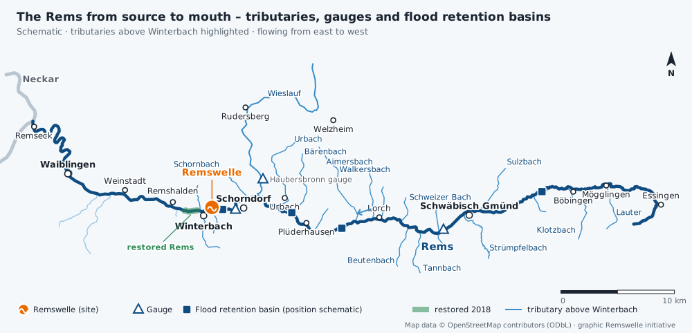
The Rems in figures
- Source: the Remsursprung near Essingen, about 551 metres above sea level
- Mouth: into the Neckar at Neckarrems (Remseck am Neckar), about 203 metres
- Length: 78.4 kilometres according to Wikipedia, "approx. 80 km" according to the municipality of Essingen
- Catchment: 582.6 square kilometres in total, 418 square kilometres at the Schorndorf gauge
- Towns and villages on the river: Essingen, Mögglingen, Böbingen, Schwäbisch Gmünd, Lorch, Plüderhausen, Urbach, Schorndorf, Winterbach, Remshalden, Weinstadt, Waiblingen, Remseck
- Largest tributary above Winterbach: the Wieslauf from Welzheim Forest, which joins shortly before Schorndorf
The Rems at Winterbach
Between Weiler and Winterbach lies the Schorndorf/Winterbach flood retention basin of the Rems Water Board (Wasserverband Rems). It is almost always empty, and the Rems flows level through the outlet structure under the Ostlandstraße bridge. Only during floods do the gates close and the valley above is impounded. Downstream, between the Winterbach treatment plant and the Hebsack bridge, the state restored the Rems over about 1.1 kilometres in 2018 – beavers have been active there again since 2022. Within Winterbach, the Weilerbach and the Höffenklinge join the Rems shortly before the bridge, and downstream the Lehenbach, Krebsbach, Bücklensweilerbach, Alsebach and, on the boundary with Remshalden, the Schweinbach.
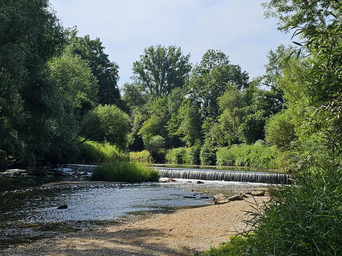
A few hundred metres above the bridge there is a small weir just before the Remsknie (bend of the Rems), by the bird tower (Vogelturm): a low fixed sill over which the Rems falls as a wide veil of water. It is not an option for the wave as far as we are concerned, but it shows what the Rems looks like at a step.
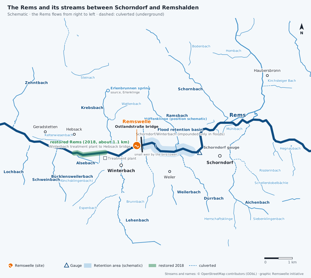
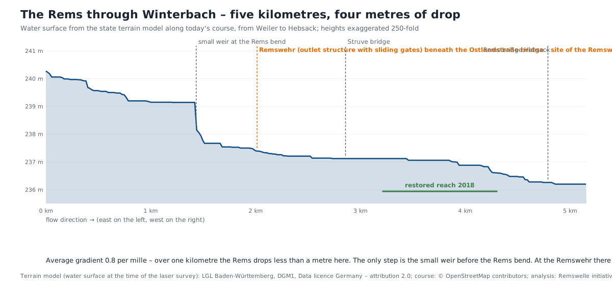
How flat the Rems is at Winterbach is shown by the state's terrain model: over a good five kilometres from Weiler to Hebsack the water surface drops only four metres, 0.8 per mille on average. The only step is the small weir before the Rems bend. At the Remswehr beneath the Ostlandstraße bridge there is none: the outlet structure of the retention basin has sliding gates that are closed at flood time; otherwise the Rems flows through on the level. A wave needs a drop over a short distance – how that could be obtained at the outlet structure is the question for the feasibility study. → Hydraulics of a river wave
Why this belongs on a surf-wave site
The tributaries determine how much water arrives at Winterbach. Floods determine when a wave may not be operated. Ecology determines whether it can be permitted. Water quality determines whether you should surf in it. And the restoration shows what value the Rems at Winterbach has today: a wave must fit into this development and must not endanger what has been achieved. → The Winterbach site
And one more thing: what you know and value, you protect. Many treasures around the Rems are known to hardly anyone: lean meadows, traditional orchards, woodland edges, sunken lanes, old vineyard walls. Those who know them can bring them into decisions – that is why we make them visible.
Why we look at the terrain
Surfers read landscapes whether they want to or not. At the coast the shape of the sea floor decides whether and how a wave breaks; anyone looking for a spot studies the coastline, aerial photos and depth charts. Windsurfers know that the wind blows differently at headlands and valley mouths than in the bay next door, and learn to see the terrain as part of the weather. We bring that view to Winterbach: elevation profiles, aerial photos and the state's terrain model show where the Rems has its gradient, where the cool air comes down at night – and, incidentally, what the landscape tells about its history. We are neither geologists nor meteorologists; we write down what we notice and say where it is documented and where it is not. → Cool air for Winterbach · → When this was sea · → Traces in the Hungerberg
Surfers don't usually talk about their methods. Anyone who has found a spot with charts, wind and tides keeps it to themselves – a secret spot stays empty only as long as nobody talks about it. Here we make an exception. The Remswelle is not meant to be a secret but the opposite: a place where people meet.
Sources: Gemeinde Essingen (municipality of Essingen), "Remsursprung" · Wikipedia, "Rems" and "Liste der Zuflüsse der Rems" (accessed 26.09.2026) · LUBW, Deutsches Gewässerkundliches Jahrbuch Rheingebiet Teil I 2009 (Schorndorf gauge) · Wasserverband Rems, "Hochwasserrückhaltebecken" · Regierungspräsidium Stuttgart, "Die Rems fließt wieder", 19.12.2018 · Zeitungsverlag Waiblingen, 08.03.2023 (beaver) · Map data © OpenStreetMap contributors (ODbL)