
Rems and Winterbach · River, water, nature and history
Why does Winterbach look like this?
Winterbach lies where it lies because rock, water and roads wanted it so. Sea and river made the valley, a crossing of the Rems made the village, the sun on the Hungerberg made the vineyards, and floods set the limits of growth. On many pages of this section we have examined the individual pieces with maps, aerial photographs and the state's terrain model. Here we put them together into one story – from the Jurassic sea to the newest housing estate, in seven steps. Each step points to the page where the evidence is.
1. The rock: a valley of soft marl
Everything begins with the strata. The Rems valley at Winterbach lies in the Keuper, a sequence of clay marls and sandstones deposited around 230 million years ago in river deltas and shallow lagoons. The valley floor is Gipskeuper (gypsum Keuper): soft, colourful, easily eroded – which is why the valley is so wide and flat here. Above it follow the Schilfsandstein and the Bunte Mergel (coloured marls); on top of the Hungerberg and the Schurwald lies the hard Stubensandstein that holds the heights. That the land later lay beneath a sea whose mud became oil shale at Holzmaden, and that it has since been lifted by hundreds of metres and eroded again, explains why the Rems today flows at 238 metres while the Hungerberg rises above 400 and the Schurwald above 460 metres. And it explains why the slopes slide: Gipskeuper swells, marl creeps. → When this was sea
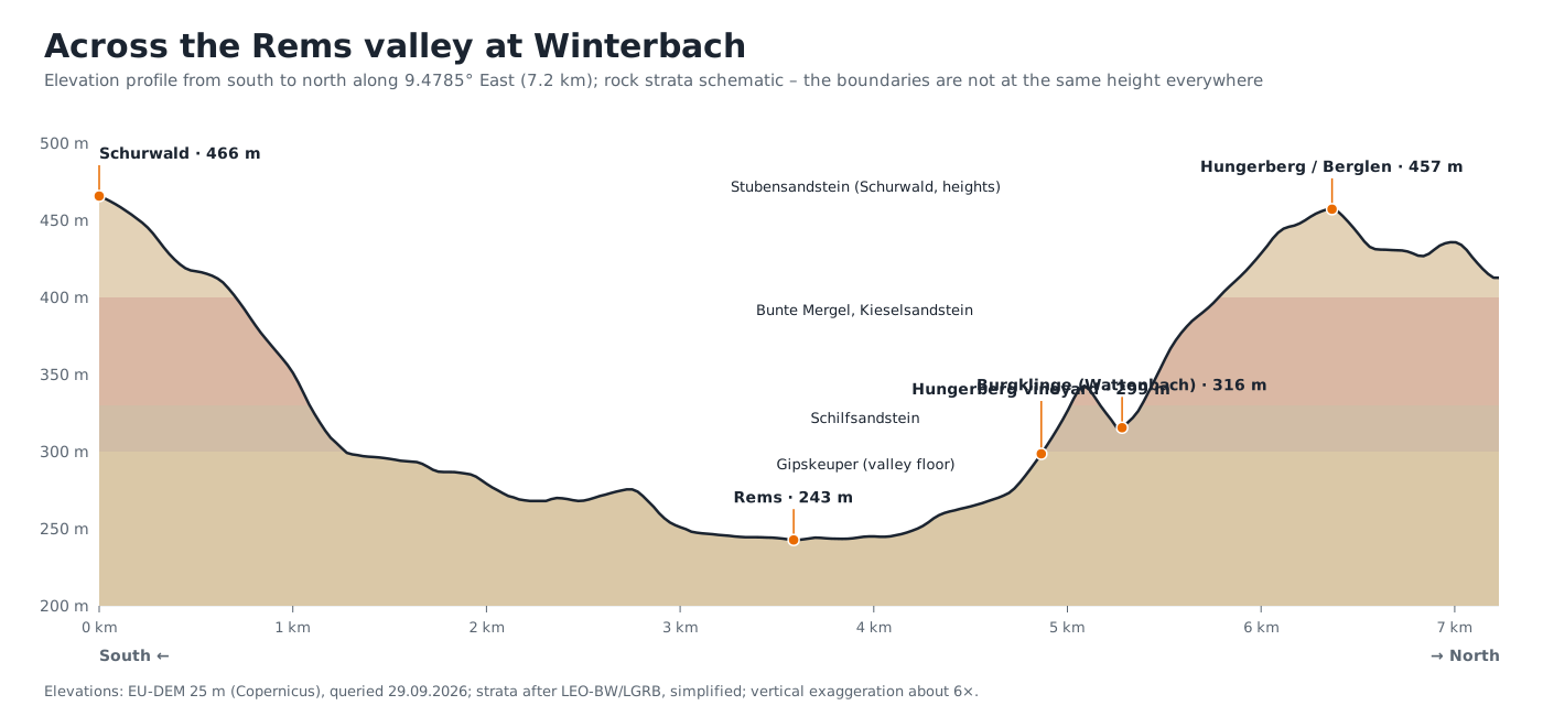
2. The water: one river, many streams, springs on the slopes
Into the soft valley the Rems found its way – in bends, with loops and oxbows, as the cadastral map of 1832 still shows. The streams come from both sides: from the Schurwald the Lehenbach, which "never runs dry", the Krebsbach, Bücklensweilerbach and Alsebach; from the Hungerberg the Weilerbach and the Höffenklinge. Where sandstone lies on marl, water emerges: according to the 1851 district description, Winterbach had "the best spring water in the Rems valley". The floodplain in between was wet – field names such as Pfingstwasen, Steinwasen and Riedwiesen recall it. To this day, water decides where building takes place and where it does not. → Tributaries of the Rems · → Springs and hillside water · → The historic course of the Rems
3. The crossing: why the village lies exactly here
A river in a marshy valley is an obstacle – and where it can be crossed, a settlement arises. The old salt road from Schwäbisch Hall to Esslingen avoided the wet valley floors: it came over the heights from the north, descended to the Rems, crossed it at Winterbach and climbed again via the Pflasterweg to the Engelberg. Whoever held the crossing held the road. That explains why a royal manor, a fortified church and no fewer than two castles come together here. St Michael's church, built in 1309 as a fortified church, stands on a small knoll at 246 metres, a few metres above the valley – dry, with a view of the crossing. The village centre grew around it, where the Lehenbach comes out of the Schurwald into the valley – between the river and the foot of the Schurwald; today the stream flows culverted beneath the village centre. Which sunken lanes and castle sites remain of the old road, we searched for in the terrain model. → Traces in the Hungerberg
4. The sun: vineyards on the south slope
The Hungerberg north of the Rems faces south. In 1832 vines stood on around 90 hectares of the municipal area, almost all on this slope, in narrow plots up to the forest. Terraces, stone ridges and dry-stone walls still trace the old division in the terrain; the relief image makes them visible even where forest now stands. In the 19th century fruit trees replaced many vines, around 1910 phylloxera reached Winterbach too, and after the Second World War many plots became gardens; today about five hectares of vines remain. What is left is a mosaic of orchards, lean meadows, forest edges and ravines that ranks among the most species-rich habitats of the area – and that only remains if it is tended. → Traces in the Hungerberg: where vines stood in 1832 · → Forest or meadow? · → Vineyards of tomorrow
5. The work: mill, rafting, mill race
The river was power. At the Remsknie a mill race branched off and led to the Winterbach mill; the field names Wehräcker, Mühlbachäcker and Mühlfeld still lie along its course. On the Rems itself firewood was floated down to Ludwigsburg, loose in logs, through a rafting chute at the Winterbach mill weir – until the railway came. → The Rems through time · → Weirs and fish passage
6. Rail and road: the village turns around
In July 1861 the Rems railway opened; in 1862 timber was floated for the last time. With the station Winterbach gained a second centre, and in the 20th century the federal road was added. Both lie in the valley, and both drew the settlement from the old core out into the plain. For that the river had to give way: in the 1930s and 1950s the Rems was straightened and embanked, the loop above the village disappeared, and the meandering river became a trapezoidal channel. Only in 2018 did it get room again below the village, over a good kilometre. → The historic course of the Rems · → Restoration at Winterbach
7. Growth and its limits
Since 1953 the built-up area of Winterbach has multiplied – estate by estate, mostly at the foot of the slopes and in the plain, as the series of aerial photographs shows. Water sets the limits of growth: after the flood of Christmas 1919 "the village was completely under water", and in 1990 the Rems flooded the valley from Lorch to Remshalden. The Rems Water Board (Wasserverband Rems) answered with retention basins; the Winterbach basin beneath the Ostlandstraße bridge has been in operation since 2005 and was full to the brim twice in June 2024. What is not to be built on is laid down today by the regional plan: green corridors and green breaks in the floodplain and on the slopes. And the climate adds a new limit: the cool night air from the Lehenbach valley and off the Hungerberg needs open paths into the village. → Winterbach grows · → Flood protection · → Cool air for Winterbach
Everything on one map
Field names, streams, springs, protected areas, natural monuments, the vineyards of 1832, traces of history and an elevation profile you can draw yourself: our maps lay the layers of this story on top of each other. → Maps of Winterbach
What this means for the Remswelle
The Remswelle is to be built at a place that has been a crossing for a thousand years: here the salt road crossed the river, here lay the royal manor and the castles, here the retention basin protects the village today. Whoever understands the wave understands the village – and vice versa. → The site
Frequently asked questions
Why is the Rems valley so wide at Winterbach?
Because the Rems flows here in the Gipskeuper, a soft clay marl that it could erode easily. Upstream and downstream, where harder strata crop out, the valley is narrower.
Why does the church stand on a hill?
St Michael's church stands on a small knoll at around 246 metres, a few metres above the Rems. The ground was dry there and the view of the river crossing open; in 1309 it was built as a fortified church.
Why are there so many terraces and walls on the Hungerberg?
The south slope was vineyard until the 19th century; in 1832 vines stood on around 90 hectares of the municipal area. Terraces, stone ridges and dry-stone walls date from that time and are legally protected today.
Why does the Rems flow so straight through Winterbach?
Because it was straightened and embanked in the 1930s and 1950s to gain land and carry floods away faster. Below the village it was restored over a good kilometre in 2018.
Sources
The evidence for each step is on the linked pages: district description of Schorndorf 1851, regional geography of Baden-Württemberg, cadastral map of 1832 and aerial photographs of the State Office for Geoinformation and Land Development (LGL-BW, Data licence Germany – attribution 2.0), terrain model DGM1, Heimatverein Winterbach (information sheet "Kulturgeschichtliche Wege"), Rems Water Board, regional plan of the Verband Region Stuttgart, LUBW (data from the environmental information system).
Last updated: 15 October 2026 · Initiative Remswelle