
Rems and Winterbach · River, water, nature and history
Traces in the Hungerberg
The Hungerberg is Winterbach's sunny side: vineyard, orchard meadows, gullies and forest edge above the north bank of the Rems. Anyone walking there walks across a thousand years of history without noticing – over the remains of a castle, an old long-distance road, boundary ditches, abandoned quarries and areas the state protects today as natural monuments. The Heimatverein Winterbach has described these places on its cultural history trails. We looked at them with a tool surfers use anyway: reading the terrain.
Anyone who waits for waves learns to read a landscape. At the coast the shape of the sea floor decides whether a wave breaks; windsurfers know that the wind blows differently at headlands and valley mouths than in the bay next door. For the Remswelle we therefore look at elevation profiles, aerial photos and the state's terrain model – and things catch the eye that have nothing to do with surfing, but a lot to do with Winterbach. → The Rems · → Cool air for Winterbach
The castle in the Burgklinge
The field name Burgklinge – "castle gully", a small valley north of the Rems east of Rohrbronn – is no accident. A castle stood there that has since vanished. According to Walter Wannenwetsch's chapter in the volume "Die Burgen im Rems-Murr-Kreis" (1994) it was a small moated castle on the Wattenbach stream, with the field names Hof and Hofäcker beside it that probably belonged to the castle. What remains is the castle mound: an elongated hill about 70 metres long and 12 metres wide, still 50 by 4 to 5 metres on top, disturbed by the building of a house and an air-raid shelter dug into it; cellar remains are said to have been cut during construction but were not examined. On its cultural history trails the Heimatverein Winterbach describes the site more cautiously as the "location of a fortification on a spur, not yet dated"; it is listed as an archaeological monument.
What the terrain model shows: In the relief an elongated ridge lies at this spot, aligned almost exactly north, about 80 metres long and 20 metres wide, with a level plateau. It rises four to five metres above the two gullies to its left and right, which join below it – a spur. On the uphill side, where the ridge merges into the slope, there is a saddle of almost two metres: the place where castles had their neck ditch, separating the spur from the hill.
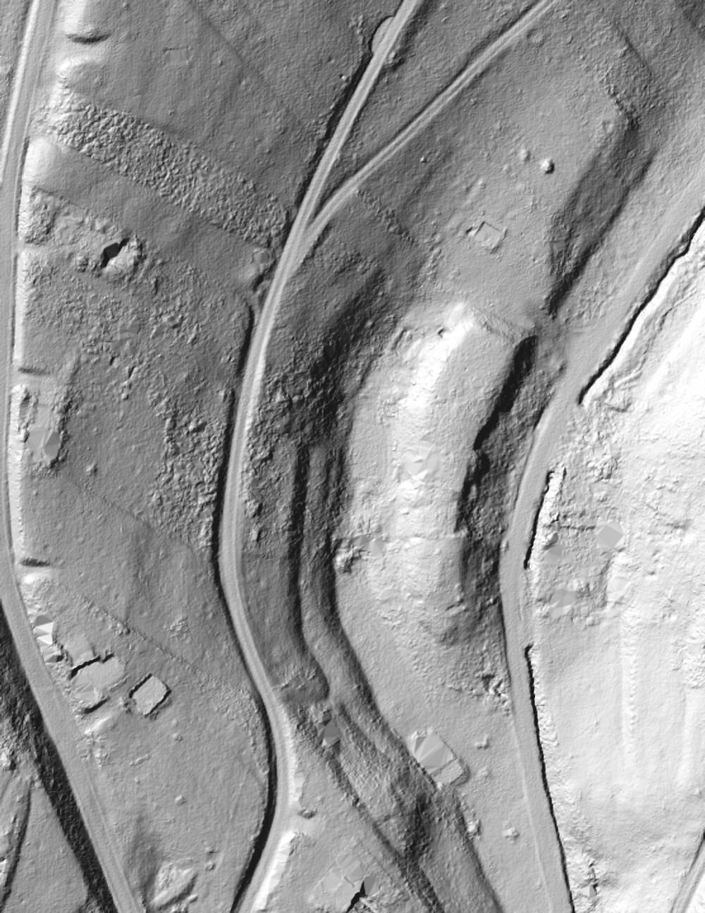
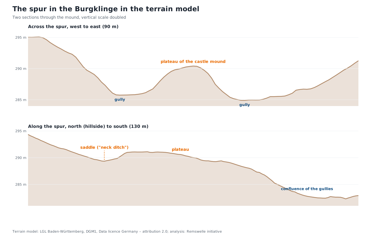
What we conclude: The shape confirms the castle mound – spur position, plateau and neck ditch are exactly what Wannenwetsch describes, and the dimensions match. How old the structure is and whether a palisade or a wall stood on it, the relief cannot say; that remains a matter for the heritage authorities.
What the castle meant is shown by the village's history: Winterbach was an old royal estate. Emperor Henry III stayed here in 1046 and 1048, in 1080 Henry IV gave the village to the cathedral chapter of Speyer, in 1276 Count Ulrich II of Württemberg issued a charter at Winterbach, and in 1467 Agatha von Baldeck sold her Winterbach estates to Count Ulrich V. The castle in the Burgklinge probably secured an old trade route – with a wooden palisade rather than stone walls.
A second castle stood in the middle of the village: a motte between Hauptstraße, Seestraße, Mühlstraße and Neue Gasse, mentioned in 1400 in a rent book as "Burggraben" (castle moat) and "burgwieß by der mulin" – the castle meadow by the mill. The mound was levelled when the quarter was rebuilt. That castle, mill and mill channel lay so close together is no coincidence: water was power and protection at once. → Historic course of the Rems
A fortification from Celtic times?
On the Rohrbronner field the Heimatverein names another "castle site": the "location of a Celtic fortification", of which the defensive ditch on the uphill side is said to be still visible in the terrain. The Keuper uplands between the Neckar and the Swabian Forest were settled in the Hallstatt and La Tène periods; burial mounds and rectangular enclosures are numerous in the region. For Winterbach the Rohrbronner is the only site described in this way.
What the terrain model shows: In the Rohrbronner field there is a single clear, man-made channel: a ditch that runs from the Krebsbach obliquely up the slope and along the forest edge, a good 140 metres long, then turns south and continues as a shallower channel along the eastern side of a block of old vineyard strips. Along its whole length a low bank lies on the inner side, towards the block. So the block is enclosed by ditch and bank on its uphill sides – north and east – while to the west a track and the Krebsbach gully bound it. The detective work below is devoted to it. There is no spur with a level plateau here as in the Burgklinge; the block is a slope.
What we conclude: The ditch is there, visible and unmistakably artificial. Ditch outside, bank inside, drawn around an area on the uphill side – that is the shape the Heimatverein describes as a "defensive ditch on the uphill side", and it is at the same time the shape of a drove ditch that sealed the vineyards off from the forest pasture. Both look the same in the relief. Whether a Celtic structure lay here whose ditch later served as boundary and drove ditch, or whether the ditch was a boundary from the start, the terrain model cannot decide at present – only specialists of the State Office for Monument Preservation can, if need be with a spade. We note the possible Celtic connection and will follow it up when the occasion arises: in the literature on the Hallstatt and La Tène periods in the Rems valley, in the state's find reports and in conversation with the Heimatverein.
The salt road
The Hofhäusle on the Hungerberg "lies on the old salt road that ran from Schwäbisch Hall to Esslingen", the Heimatverein writes. Salt from the brine springs of Hall was for centuries one of Württemberg's most important trade goods, and the carters avoided the marshy valley floors: they came over the heights from the north, descended to the Rems, crossed the river and climbed again on the other side – at Winterbach over the Pflasterweg ("paved way") to the Engelberg. That explains why a royal estate, a fortified church and two castles come together at this river crossing: whoever held the crossing held the road. Where exactly the route ran on the Hungerberg is not recorded. Old cart roads leave sunken lanes, and sunken lanes can be found in the terrain model – what we found is below under "Where the salt road may have run".
Boundaries in the terrain: drove ditch and boundary stones
Along the forest edge on the Hungerberg runs the Triebgraben, "reaching as far as the Wüstenfurt" and "still partly well preserved", as the Heimatverein writes. A Triebgraben is the boundary fortification of the forest pasture: a ditch, a steep bank or a wall towards the fields or vineyards, so that the cattle grazing in the forest did not stray into the crops. Such ditches also marked rights – who was allowed to graze, cut wood and gather where. The boundary stones on the municipal boundary with Rohrbronn, which today belongs to Remshalden, are similarly old: they still stand at the bends of the boundary, often where a ditch or an old path runs too.
What the terrain model shows: At the forest edge above the old vineyard strips runs a ditch with a steep scarp on the uphill side and a low bank on the downhill side – the shape that belongs to a drove ditch. It lies on the municipal boundary. More in the detective work below.
Sunken lanes, quarries, marl pits
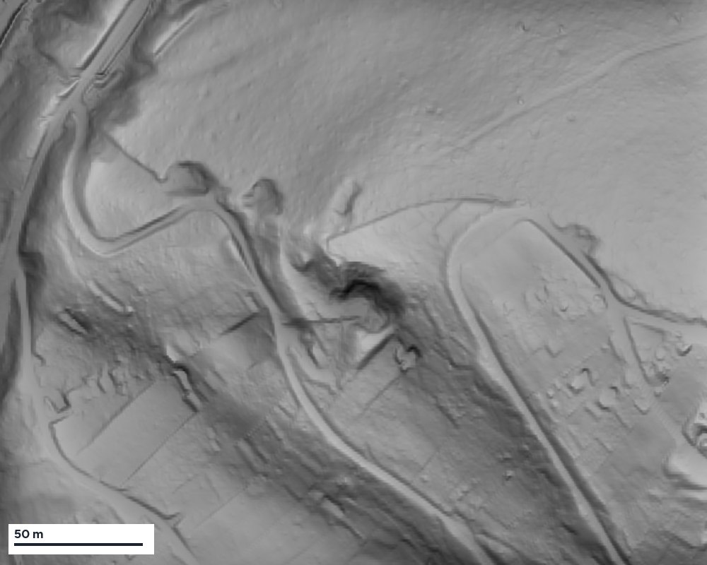
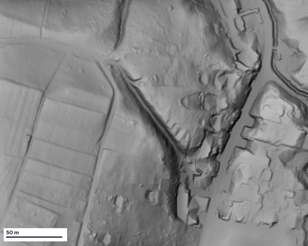
Where people drove up the same slope for centuries, the tracks dug themselves in: wheels, hooves and rain deepened them into sunken lanes, often several metres deep. South of the village the state protects a "wooded sunken lane" as a natural monument, on the Remshalden side a "marl pit and sunken lane with field copse". The quarries belong to these traces too: the former Stubensandstein quarry on the Hungerberg, today a natural monument, from which the winegrowers fetched their Fleins for the vineyard walls, another smaller quarry, and the Kerfgruben – marl pits – from which they carried marl as fresh soil into the vineyards. → When this was sea
What the terrain model shows: The sunken lane south of the village is a cut up to four metres deep in the relief, with sides steeper than 35 degrees. The Stubensandstein quarry on the Hungerberg shows quarry faces up to five metres high and more than 60 degrees steep – walls no slope forms by itself. The smaller quarry can be made out as an edge of one to two metres. All of it confirms what the Heimatverein describes.
Natural monuments on the slope
On the Hungerberg and in the gullies the state lists a series of area natural monuments – small protected areas for individual habitats that bear the names of the landscape: the Rappenklinge, a "wooded and damp hollow", the "former quarry", a "road embankment with field copse", a "plant occurrence on the Hungerberg", the "pond in the Hofäcker field" next to the Burgklinge and – at the transition to Rohrbronn – the "steppe heath and forest edge at the Böhnlöchle". A steppe heath is a dry, sunny slope with open woodland and poor grassland, typical of Gipskeuper and now rare. All these areas can be displayed in the history map. → History map · → Wildlife and plants on the Rems
Among the traces on the slope is a piece of social history too: the Homöopathenhäusle in the Höffenklinge, built in 1930 by the homeopathic association as a light-and-air bath. → Springs and hillside water
The traces on one map
Castles, the salt road and quarries, the sunken lanes, the natural monuments and the vineyards of 1832: the history map shows where the traces on this page lie. The location of the traces is approximate only.
Detective work: a ditch at the forest edge
What caught our eye
At the edge of the Hungerberg, where the municipality of Winterbach borders Rohrbronn, a ditch runs from the Krebsbach up the slope and then along the forest edge: about two metres deep, ten metres wide, lined in places with sandstone. For a sunken lane it is almost too steep, for a stream it lies wrong – it runs across the slope. A Celtic rampart? The Heimatverein's drove ditch? An old path? We wanted to know.
The cadastral map of 1832
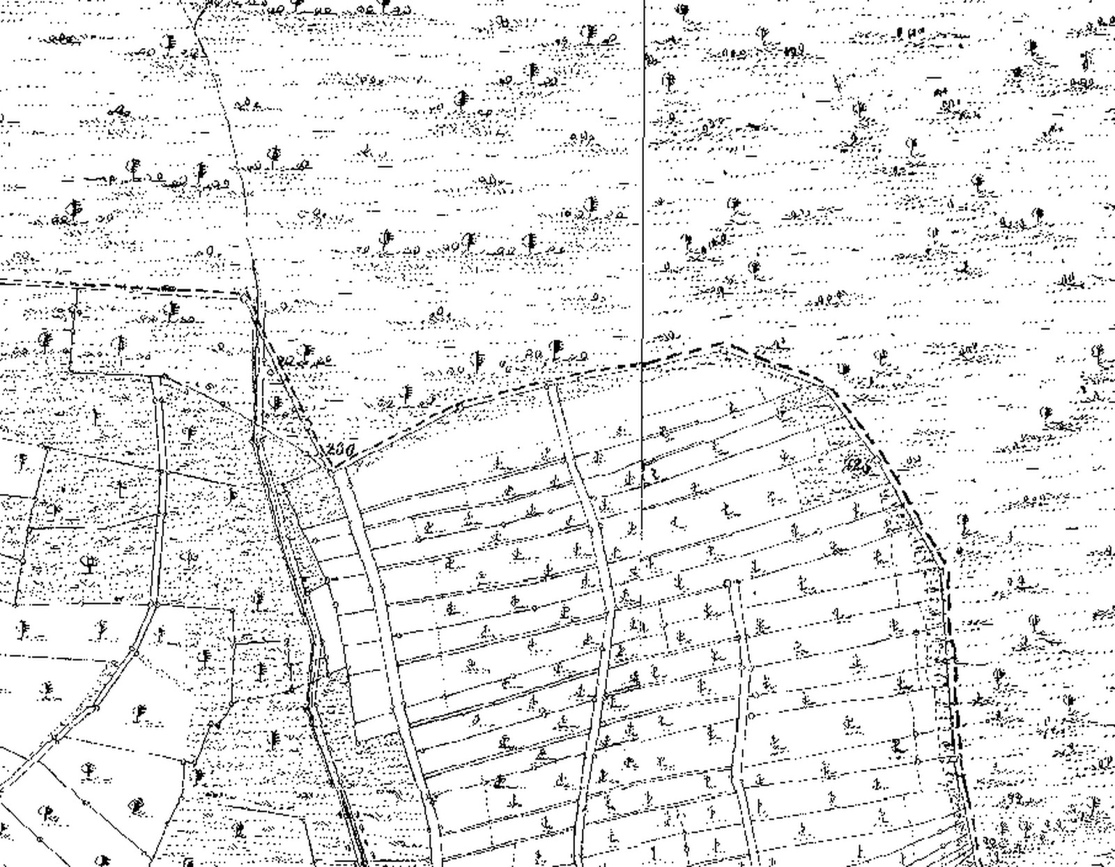
The first thing to reach for was the oldest accurate map of Winterbach there is: the Württemberg cadastral map of the first survey, drawn in 1832. At this spot it shows a block of narrow strips with vine symbols – vineyards in the Bohnlöchle – and forest above them. The dashed line between the two is the municipal boundary. No path is drawn along the forest edge.
The aerial photo
Today's aerial photo was no help: the ditch lies under trees, and where the vineyards were, there are orchards and hedges now. You see crowns, not ground.
The hillshade
Then the terrain model. The state of Baden-Württemberg surveys its surface with airborne laser scanners and removes trees and buildings by calculation; what remains is the bare ground, an elevation value every few centimetres. To make it visible it is shown as a hillshade – in German a Schummerung, an old cartographers' word: map makers once shaded mountains by pencil, darkening the shadow sides so that the terrain looked three-dimensional. Today the computer does it: an imaginary light falls obliquely from the north-west onto the model, every edge casts a shadow, every ditch becomes a dark line with a bright far side. Under the forest, where no aerial photo shows anything, the ground becomes as legible as a plaster relief.
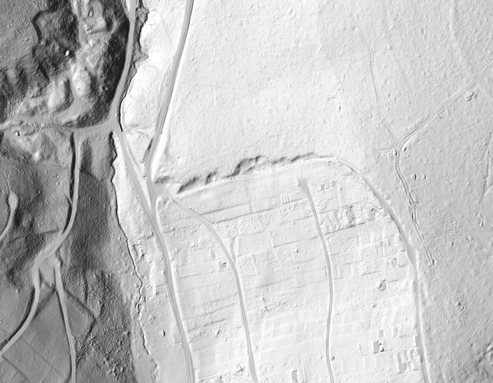
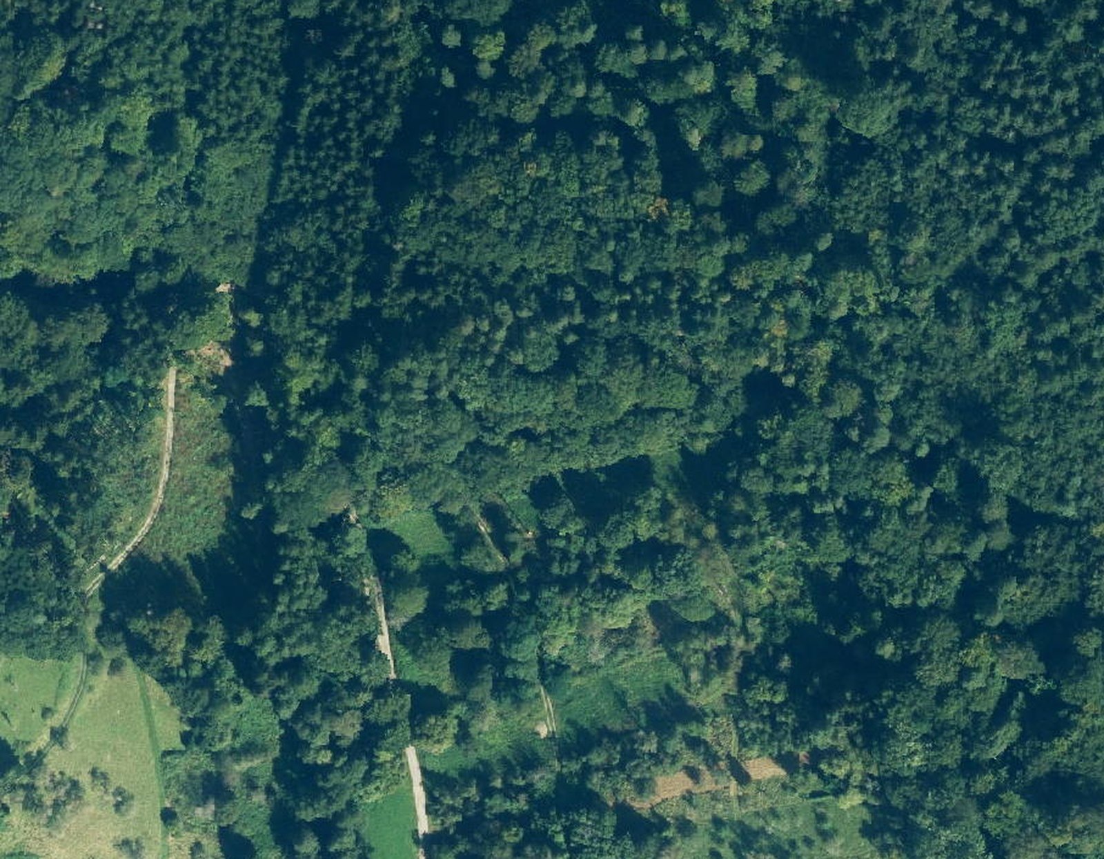
In the hillshade the ditch is a sharp, slightly kinked line – straight pieces that adapt to the slope. Nature makes no straight lines. To its left the Krebsbach gully winds, as water does. And below the ditch lies a pattern of fine steps running along the contour.
Laid on top of each other
Lay the 1832 map over the hillshade and everything falls into place: the ditch lies exactly on the dashed municipal boundary, at the upper edge of the vineyard block, with the forest on the other side. The fine steps below are the boundaries of the vineyard strips of 1832 – they are still in the ground today, although the vines have been gone for generations.
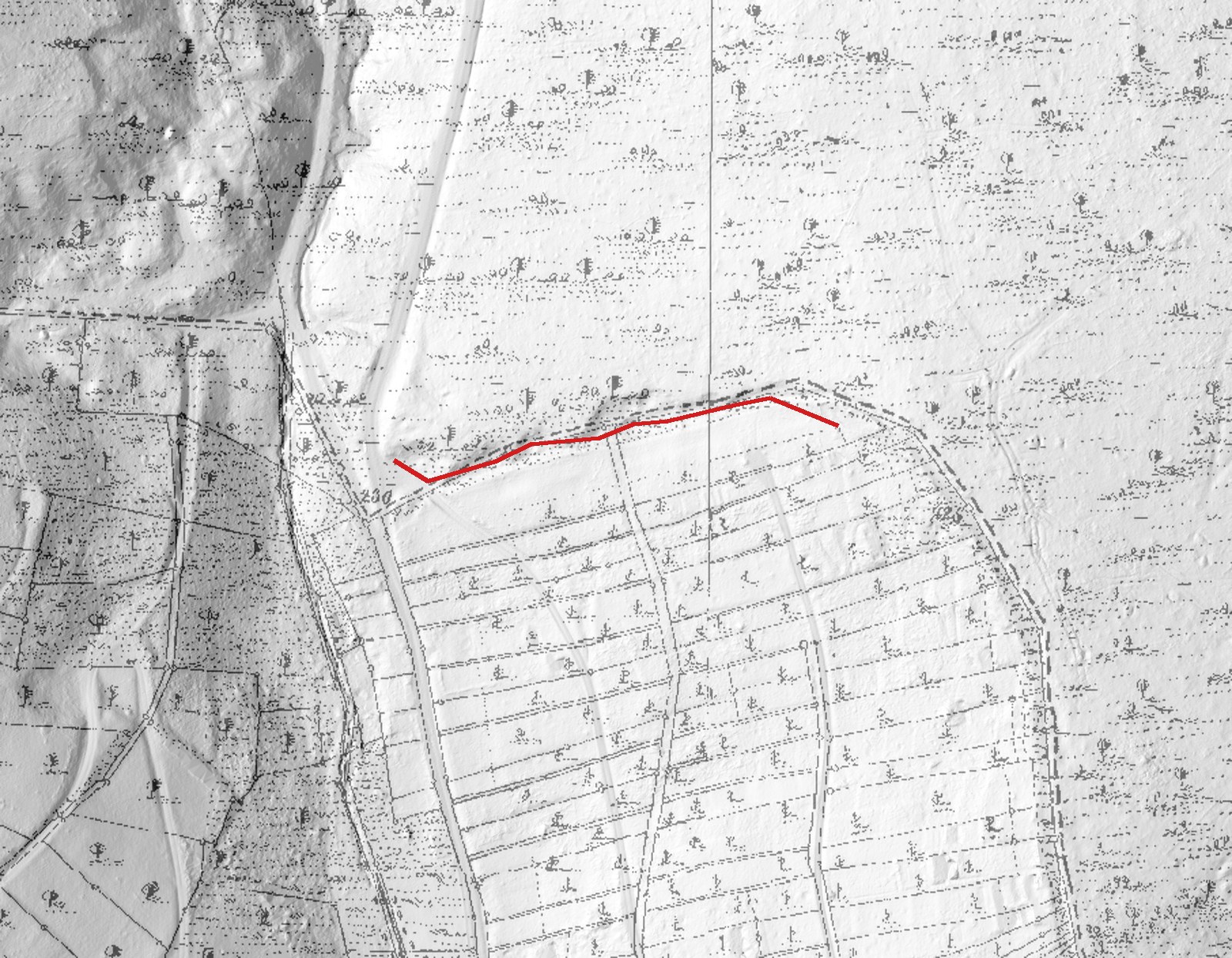
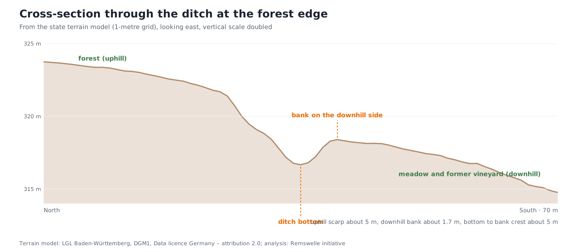
The terrain model also gives numbers. A section across the ditch shows a scarp about five metres high on the uphill side, a narrow bottom and, on the downhill side, a low bank of a good metre and a half; below it follows an almost level terrace, then the slope with its steps. The bottom itself climbs along the ditch at more than 25 per cent – more than twice what a cart can manage.
What we conclude
The ditch is not a sunken lane: it is far too steep for wheels, and in 1832 no path ran here. Nor is it a stream. It is a boundary – the ditch between forest and vineyard on the municipal boundary, with the spoil as a bank on the vineyard side. That is exactly how the Heimatverein describes the drove ditch: the boundary fortification of the forest pasture, so that cattle from the forest did not stray into the vines. Whether the ditch was dug for that purpose or whether it is older and the boundary merely follows it, no map can say; in 1832, at any rate, it was already there as a boundary. And it may well be older: the Heimatverein places a Celtic fortification with a ditch on the uphill side in the same field, and ditch outside, bank inside, drawn around an area, is exactly the shape we see. A drove ditch reusing a much older ditch would be nothing unusual – boundaries are tenacious. We will pick up this thread again when the occasion arises. The interpretation is not certain: the model shows shapes, not age and purpose. Anyone who finds such traces should not dig but report them to the State Office for Monument Preservation – archaeological monuments are protected, and the specialists welcome tips.
And the steps?
Anyone walking across the meadows on the Hungerberg keeps stumbling over steps: a strip of woodland lies a metre above the meadow beside it, one plot half a metre below the next, most clearly above the paths. Where do they come from? We went through the possibilities – what it can be, what it is unlikely to be, and what else might come into question.
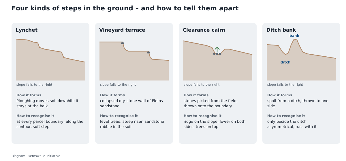
What it can be – most likely: a lynchet. Where a slope is ploughed or hoed for centuries, soil within each plot slowly creeps downhill. At the lower boundary it comes to rest, at the upper one it is lost. An unworked balk, a hedge or a forest edge keeps its old level, while the worked plot beside it becomes a little lower with every generation. This produces steps of half a metre to two metres – exactly at the plot boundaries, along the contour, with a soft, rounded edge, and staggered: every parcel boundary a step of its own. A strip of woodland a metre above the meadow, and beyond it the next step to the next plot – that is the picture of a lynchet. That the steps are clearest above the paths fits too: a path on a slope interrupts the flow of soil, material piles up above it and is missing below, and the path itself is usually cut into the slope and sharpens the edge.
What it can also be: an abandoned vineyard terrace. The Hungerberg was vineyard, and the winegrowers built their terraces with dry-stone walls of Fleins, the hard sandstone beds from the quarry on the slope. After the vines were given up the walls collapsed and today are often no more than grassy earth steps: level on top, steep in front, held by roots in the forest, rounded in the meadow. It can be recognised by the material – whoever probes the edge and hits sandstone rubble has found a wall – and by the shape: terraces are horizontal and more level than a balk.
What it can equally be: a clearance cairn. The stones picked up in clearing and hoeing were thrown onto the plot boundary, year after year. The result is a ridge lying on the slope, lower on both sides, which quickly grows over with trees because nobody mows there. A strip of woodland ten metres wide exactly on a boundary could be explained this way too – the difference from the lynchet is the ridge itself: the lynchet is a step, the cairn a hump.
What it is in one place: the bank of the ditch. Right beside the ditch at the forest edge, on the downhill side, lies a bank of a good metre and a half, as the cross-section shows. That is simply the spoil from the ditch, thrown onto the vineyard side. A ditch bank always lies only beside the channel, is asymmetrical – steep towards the ditch, gentle towards the field – and runs with the ditch, round corners too. Further down the slope, far from the ditch, it cannot be the cause.
What it is unlikely to be. A natural rock step can usually be ruled out: hard sandstone beds do crop out as an edge, but they follow the stratum, not the plot boundaries, and run straight on across the parcels. A landslide leaves a scarp at the top and a bulging toe at the bottom with hummocky, uneven ground between; that looks different from a clean, straight step. And a sunken lane has two banks with a floor between them, not a single step.
What else might come into question. Boundary hedges planted as windbreaks or stock barriers that have trapped soil over the decades – a variety of the lynchet. Old road embankments, if a path that has since vanished ran along the boundary; the cadastral map of 1832 shows where such paths lay. And boundary banks deliberately thrown up as a boundary, as happened on municipal and manorial borders – on the Hungerberg the boundary stones would be the witness.
How to tell them apart. Position first: steps at every parcel boundary, along the contour, point to lynchets or terraces; a single bank beside a channel to ditch spoil. Then the cross-section: a symmetrical, soft stair for the lynchet, a level tread with a steep front for the terrace, a hump for the cairn, an asymmetrical bank at the ditch. And finally the material: sandstone rubble in the edge means a wall, loose field stones mean a cairn, plain soil means a balk. At the forest edge of the Hungerberg the hillshade shows the pattern, the cross-section the numbers, and the spade tells the rest. Anyone who digs should know, though: where an archaeological monument is suspected, digging is a matter for the heritage authorities.
Where the salt road may have run
The Heimatverein says: the Hofhäusle lies on the old salt road. Nothing more is recorded. But old cart roads leave sunken lanes, and sunken lanes can be measured: for every present-day track and path on the Hungerberg we determined from the terrain model how far it lies below the ground on either side.
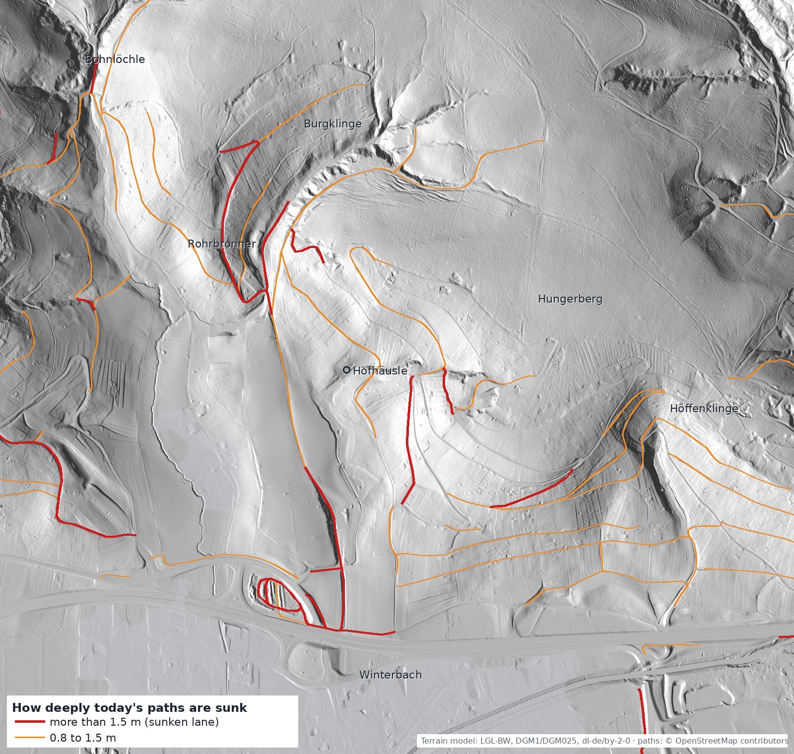
The picture shows one line that stands out: from the edge of the village a track climbs north across the Hofäcker to the Hof and on into the Burgklinge – and over a good three hundred metres it lies two to three metres deep in open fields, where no stream can have dug it. On the cadastral map of 1832 it is drawn as a road, a double line from the Bernhardsäcker through the Hofäcker up to the Hof.
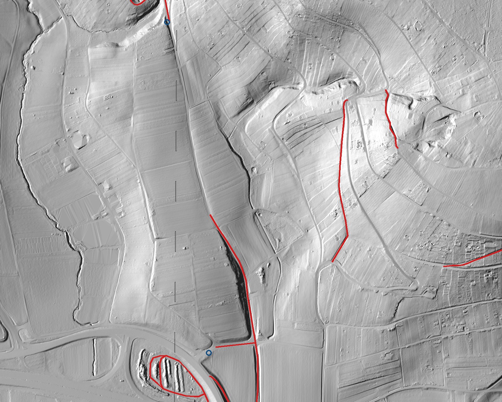
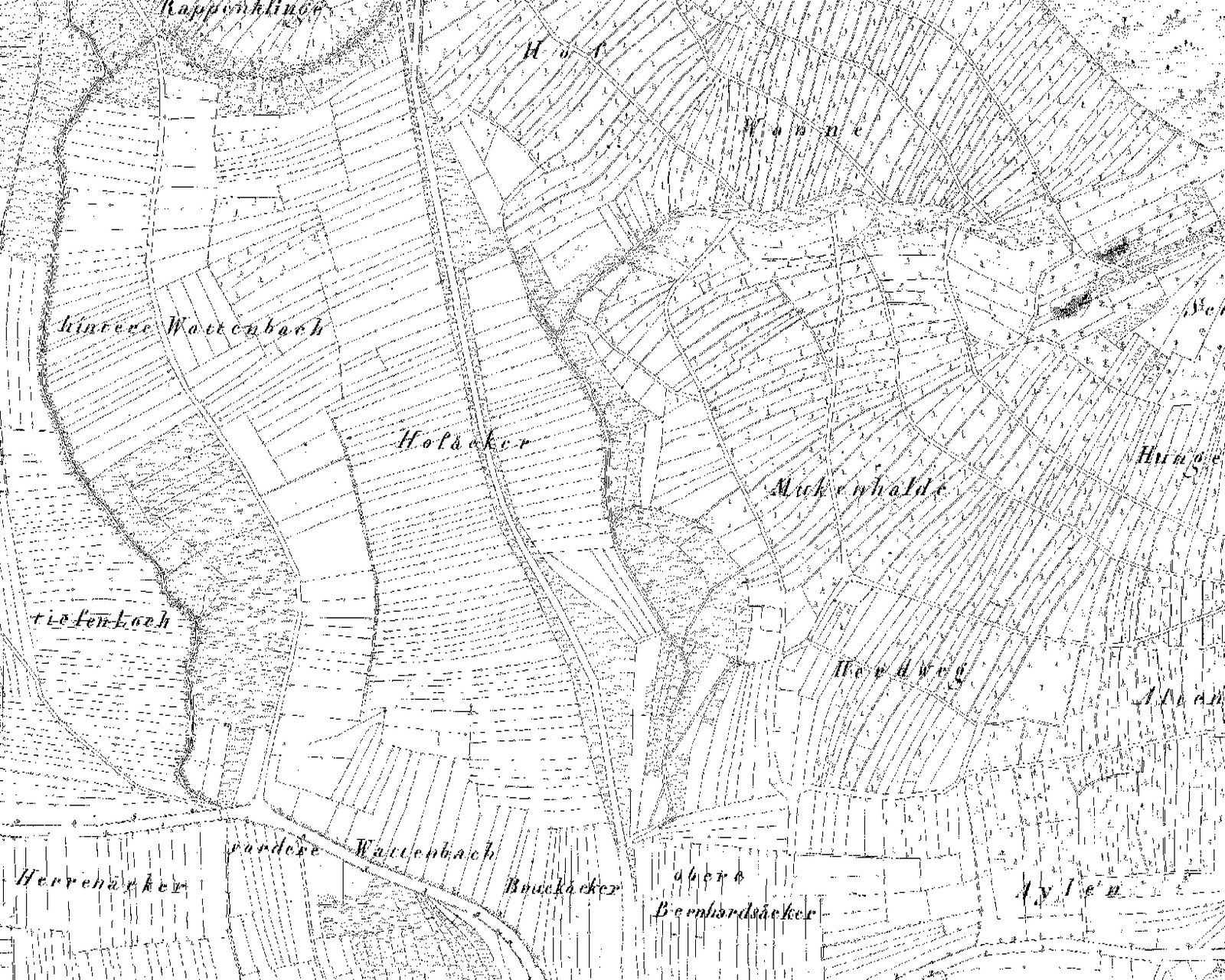
And along this line stands what accompanies old roads. At the village edge, where the sunken lane begins, two Gruhen – low and high stone benches on which carriers could set down and pick up their loads without lifting them off their backs; such benches stood on climbs that were walked with pannier and back-frame. Up at the Hof the Hofhalle, the Heimatverein's Hofhäusle: a shelter for field workers and travellers. And further north, where the track comes out of the Burgklinge onto the Berglen heights, the Königstein on the road to Buoch – a stone column on a block, with inscriptions on all four sides. Resting bench, shelter, marker stone: three witnesses of old road use on the same line, plus the castle in the Burgklinge beside it, for a castle guards a road.
None of this is proven yet, but the hypothesis has weight: the salt road may have run from the Rems crossing through the village northward over the Hofäcker, the Hof and the Burgklinge onto the Berglen, towards Buoch – and from there on to Winnenden and Backnang, where the salt from Hall came from. The route passes between the Bohnlöchle and the Höffenklinge; the paths there are shallower.
Where vines grew in 1832
The Hungerberg was a vineyard – not only tradition says so, the cadastral map of 1832 shows it. On it every land use has its own symbol: woodland is drawn with little trees, meadows with dots and dashes, fields are left white. Vineyards can be recognised by a small vertical stroke with a foot, the vine stake, in each of the narrow vineyard strips. We searched the whole map between Geradstetten and Weiler, tile by tile, for these vine symbols.
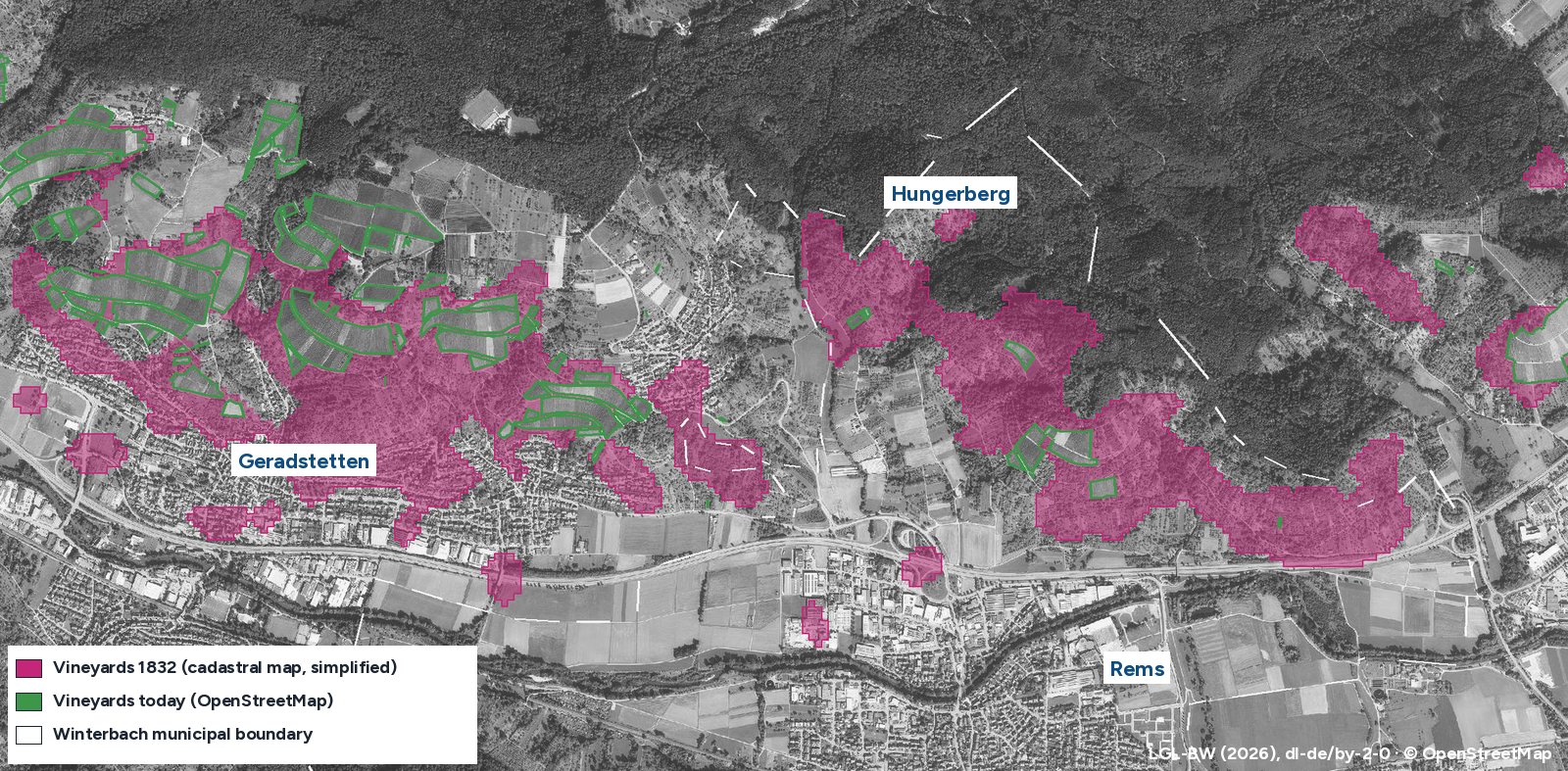
The result: in 1832 vines grew on about 90 hectares in the Winterbach district alone, almost all of them on the south slope of the Hungerberg between the edge of the village and the forest – in the sites Hungerberg, Rufen, Rohrbronner, Wanne, Altenberg, Pfaffenbrunn, Hof and Muckenhalde. Today, according to OpenStreetMap, about 5 hectares remain. The vineyards became meadow orchards, gardens, woodland and, on the lower slope, housing. It is different in Geradstetten and Hebsack, where much of the old vineyard land is still under vines.
The field names Kelteräcker and Kelterwiesenbach recall a wine press (Kelter) by their name. Names ending in -halde, on the other hand, simply mean "slope": the Gläserhalde or the Roßhalde, for example, lie outside the vineyards of 1832, the Muckenhalde half inside them.
What the slope still shows. Many of the old vineyard strips can still be seen in the terrain model today. Most clearly at the forest edge in the Rohrbronner, the block we showed above in our detective work: in 1832 it is divided into narrow vineyard strips, each with its vine symbol. Today it is meadow and orchard – but the ground has kept the old layout. Steps run across the slope, the old boundaries run down it.
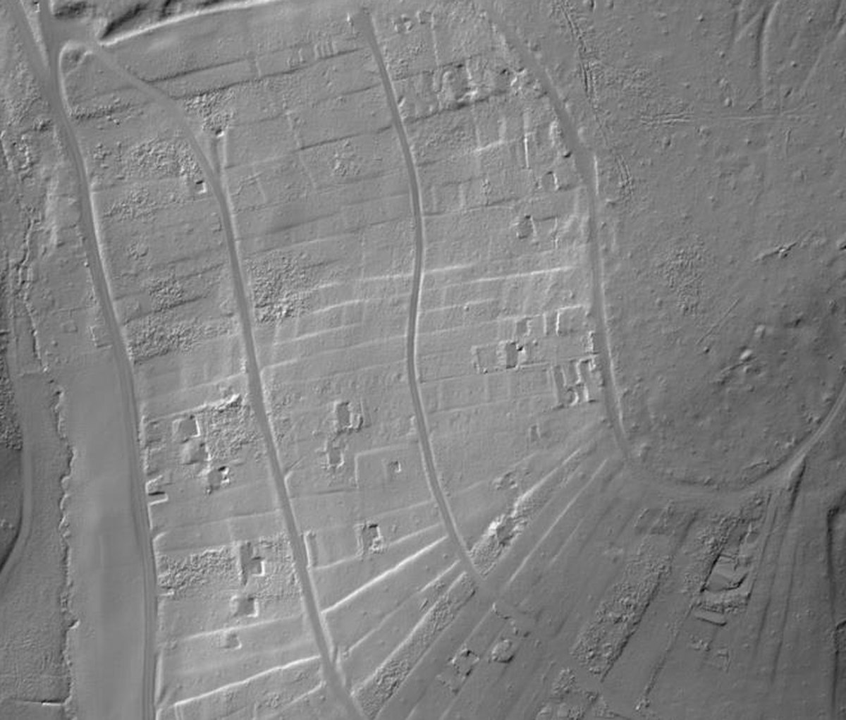
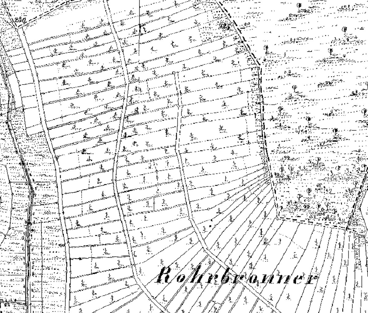
In these meadows we have also noticed rows of stones running across the slope. Two explanations fit the picture of 1832: remains of dry-stone walls that held up the vineyard terraces, or clearance cairns, onto which the stones from the soil were thrown – the diagram of steps further up shows both. If you look closely: if the stones stand in a face and the step behind is level, it was a wall; if they lie loosely in a heap on the boundary, it was a clearance cairn.
How we did it: we analysed the state survey's cadastral map at full resolution and counted, for every 25 × 25 metres, how many vine symbols – the small stroke with a foot for the vine stake – it shows. We counted tree symbols and houses as well, so that woodland, meadow orchards and the village are not mistaken for vineyards. Today's areas come from OpenStreetMap; smaller vineyards may be missing there. The result is simplified: small vineyard plots may be missing, individual areas may be misassigned. South of the Rems there were only isolated, uncertain hits; we left them out. The areas can also be seen as a layer in the history map.
From vineyard to forest – how the Hungerberg was used
The slope above Winterbach did not always look as it does today. In its leaflet on the cultural-history trails, the Winterbach local history society describes the sequence: first livestock grazed on the plateau and in the adjoining forest, and the gentler slopes were farmed. From the High Middle Ages, roughly 1100 to 1300, terraced vineyards were also laid out on the steeper slopes. From the early 19th century fruit trees replaced many of the vines, and from 1935 some viticulture returned. After the Second World War many plots became gardens and weekend plots – and today many of them are slowly becoming overgrown.
What this looks like on the ground is shown by the cadastral map of 1832 and the aerial photographs of the State Office for Geoinformation. They all cover the same area: the south slope of the Hungerberg between the Rems valley below and the forest above.
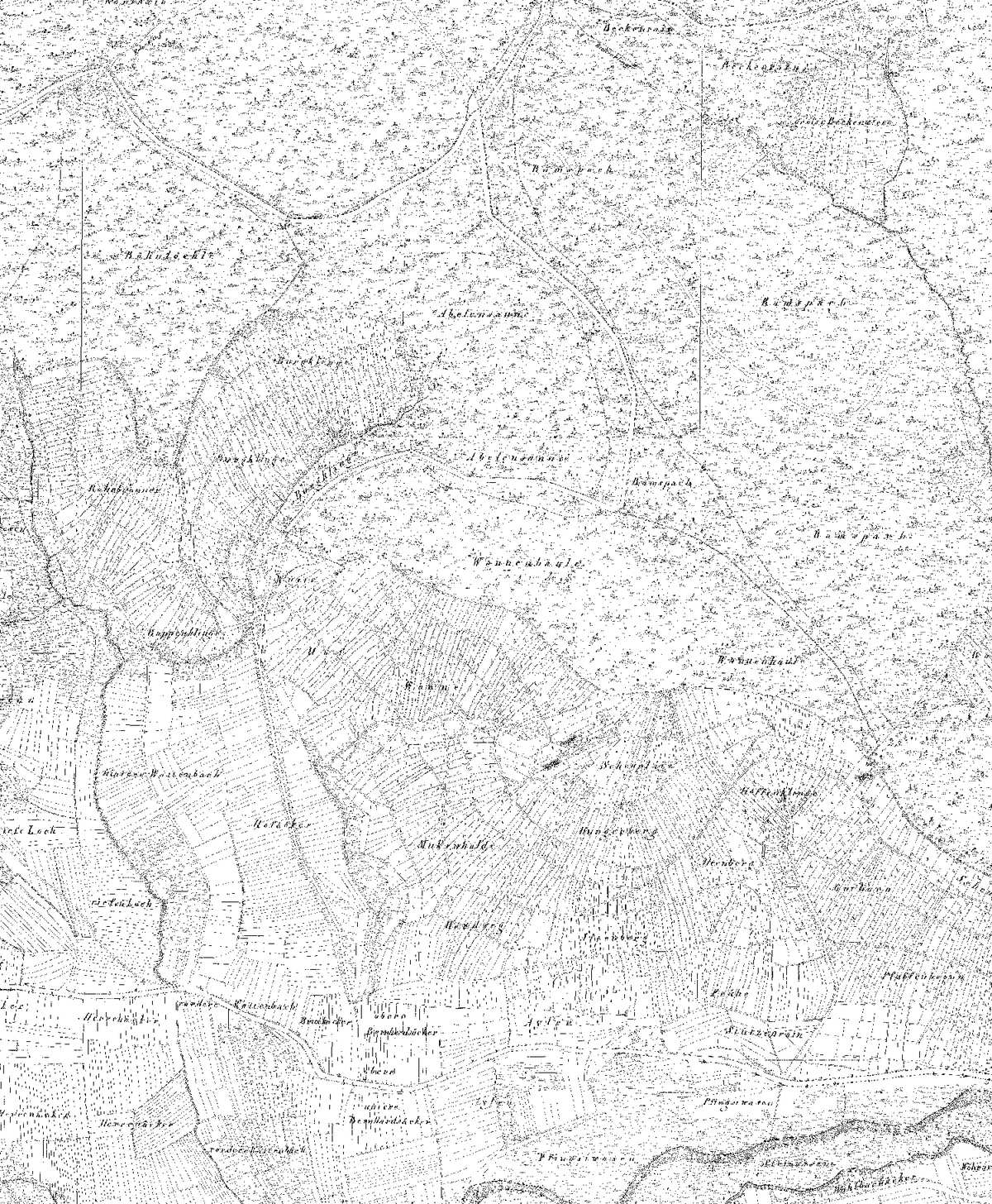
1832: The cadastral map shows the slope divided into narrow vineyard strips reaching up to the forest edge. Forest is found only at the top of the hill and in the ravines.
What the forest hides. Under the trees the old division has not disappeared. In the terrain model, which removes the trees, straight lines and steps across the slope appear where open plots with fruit trees lay in 1953 and forest stands today – the boundaries and banks of the old vineyard and orchard plots. The image pair shows a section of the slope below the Burgklinge. Why the open plots that remain are so valuable is explained on Forest or meadow?
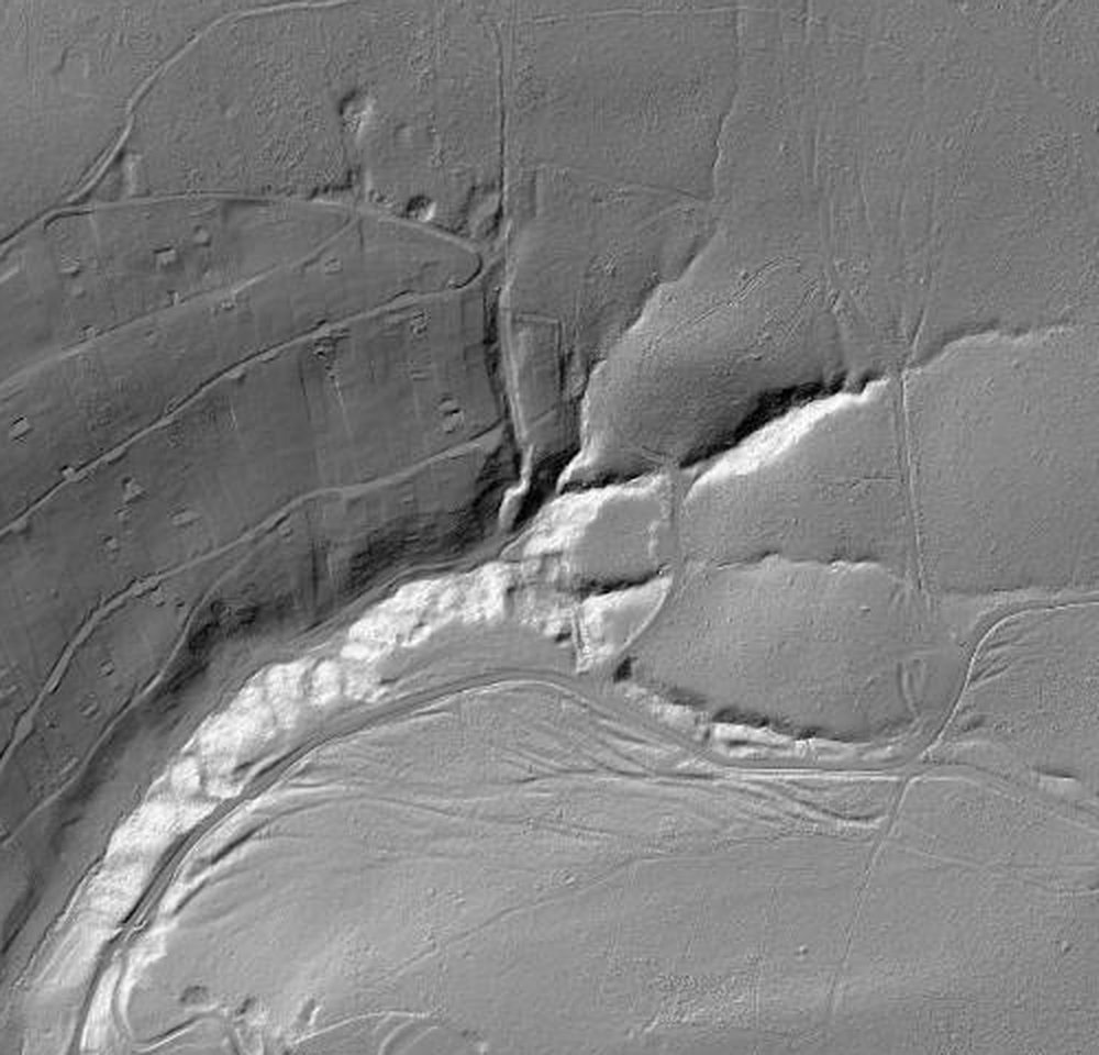
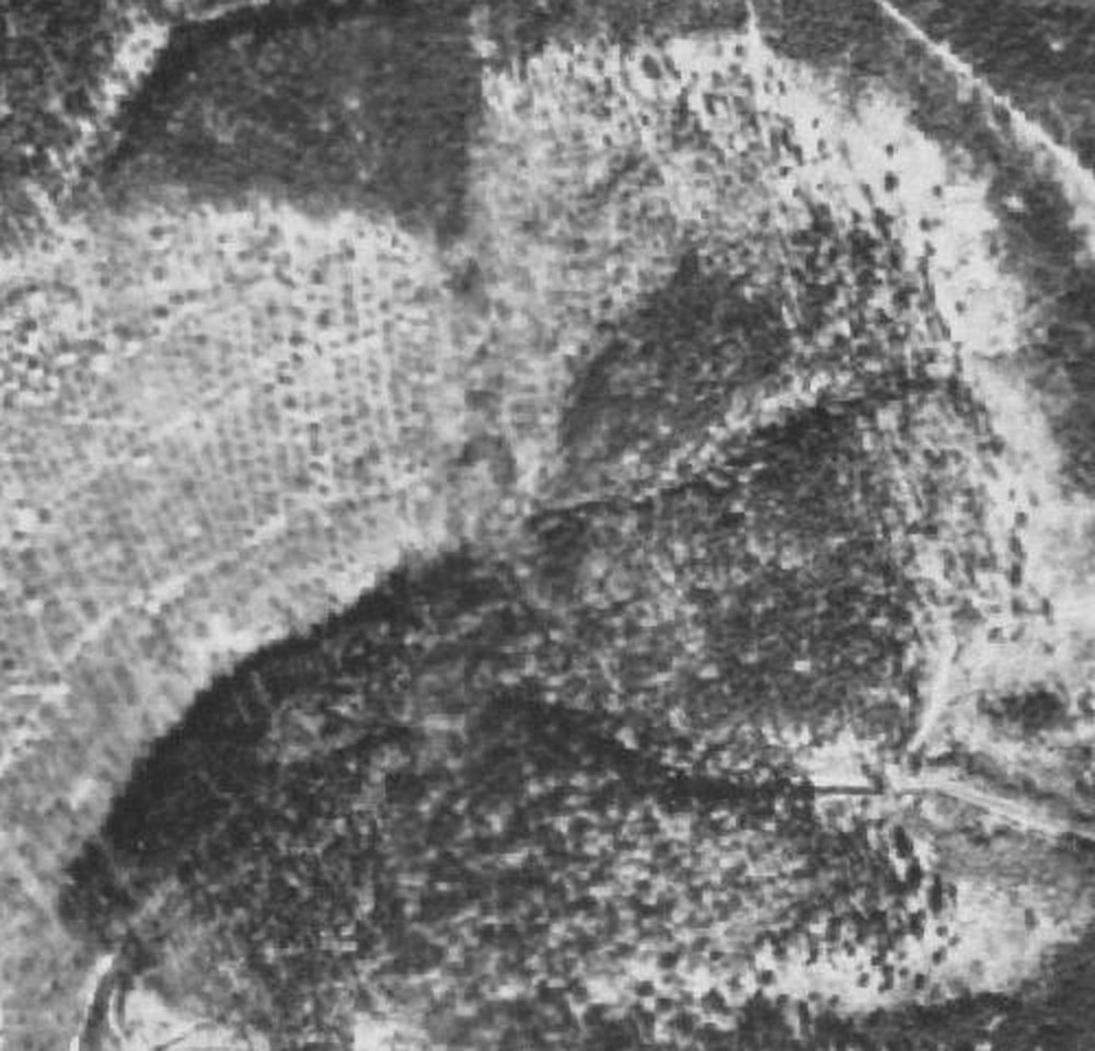
Wood pasture. Before forest and field were strictly separated, farmers drove their livestock to graze in the forest above the vineyards. According to the local history society, the Herdweg served as the drove road, and in the Scheuplätze area (“Scheuerplatz” in the leaflet) there were barns where the grazing animals found shelter. To keep the livestock out of the vines, the drove ditch separated forest from vineyard – how it runs in the terrain is described above.
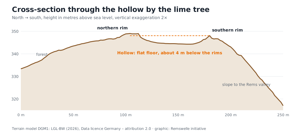
A look at the Pfaffenbronn. On its Pfaffenbronn trail the local history society points out, at a small-leaved lime tree that is a natural monument, a "high valley" between the forest edge and the path, which probably came about through the digging of marl and stone. In the terrain model the spot is easy to see: next to the lime lies a closed hollow of about 60 by 45 metres with a flat floor, around 4 metres below its rims – on the edge of the slope, behind which the hillside drops steeply to the Rems valley. A shape like this rarely forms on its own. It points rather to digging, as the leaflet suggests: in the marl pits ("Kerfgruben") the winegrowers dug marl to fertilise their vineyards, and stone for the walls. A natural origin, for example a landslide such as occurs in the Keuper, cannot be ruled out entirely.
The cadastral map of 1832 is revealing: exactly at this spot the dashed boundary between forest and vineyards bends, and right next to it stands the field name "Scheuplatz". Forest edge, grazing place and pit lie side by side. Under today's forest above, the terrain model shows many more pits, edges and spoil heaps – probably the marl pits and quarries the leaflet mentions at the forest edge. Below, the narrow steps of the old vineyard plots run through the slope, where orchards and gardens lie today.
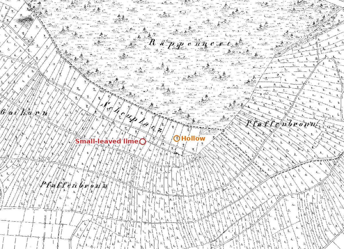
1832: At the top the forest (Räppennest), below it the narrow vineyard plots of the Pfaffenbronn. At the hollow the dashed forest boundary bends, and next to it stands the field name "Scheuplatz".
The relief image: steps, banks, pits. How much of the old land use is still in the slope is shown by a relief image of the 25-centimetre terrain model. For this we subtract the average height of its surroundings from every point. What remains is only the small-scale relief: anything slightly higher than its surroundings appears light, anything lower blue. Across the whole south slope of the Hungerberg one difference stands out. In the areas that were vineyard in 1832, the slope is finely structured – steps, boundary banks and terraces, often also where forest stands today. In the old forest above, by contrast, the ground is smooth; only ravines, tracks and pits stand out there.
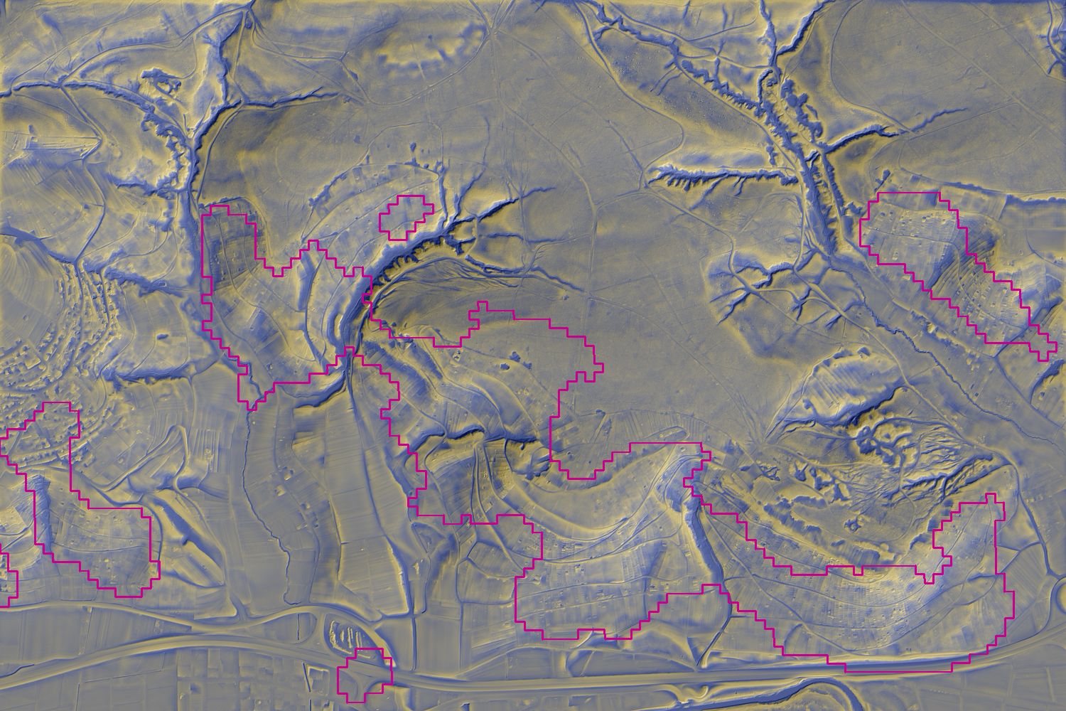
Behind many of these steps there may be dry-stone walls that are buried or overgrown today. Whether a wall or only a bank stands at a given spot can only be seen on site, though. Dry-stone walls and stone ridges have been legally protected habitats since 2022; lizards, insects and many plants find room in their joints. Incidentally, the steps cannot be counted reliably by computer: an algorithm picks up ravine edges, track embankments and stream banks just as well. That is why we show the image and give no number.
It is particularly clear at the forest edge in the Böhnlöchle:
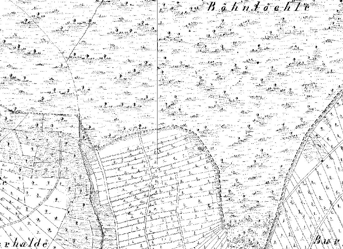
1832: At the forest edge in the Böhnlöchle lies a block of narrow vineyard plots, on the left the ravine of the Krebsbach, forest at the top.
Where the sun reaches – gradient, aspect and the vineyard of tomorrow
Anyone who does sport outdoors learns to read slopes. On ski tours and when skiing off-piste we look at steepness and aspect: where has the sun already softened the snow, where is it still powdery, where could it become dangerous? We look at the Hungerberg with the same eye.
That the Hungerberg became a vineyard has a simple reason: it faces south. The terrain model turns that into numbers. For every square metre of the municipality north of the Rems we calculated how steep it is and which way it falls.
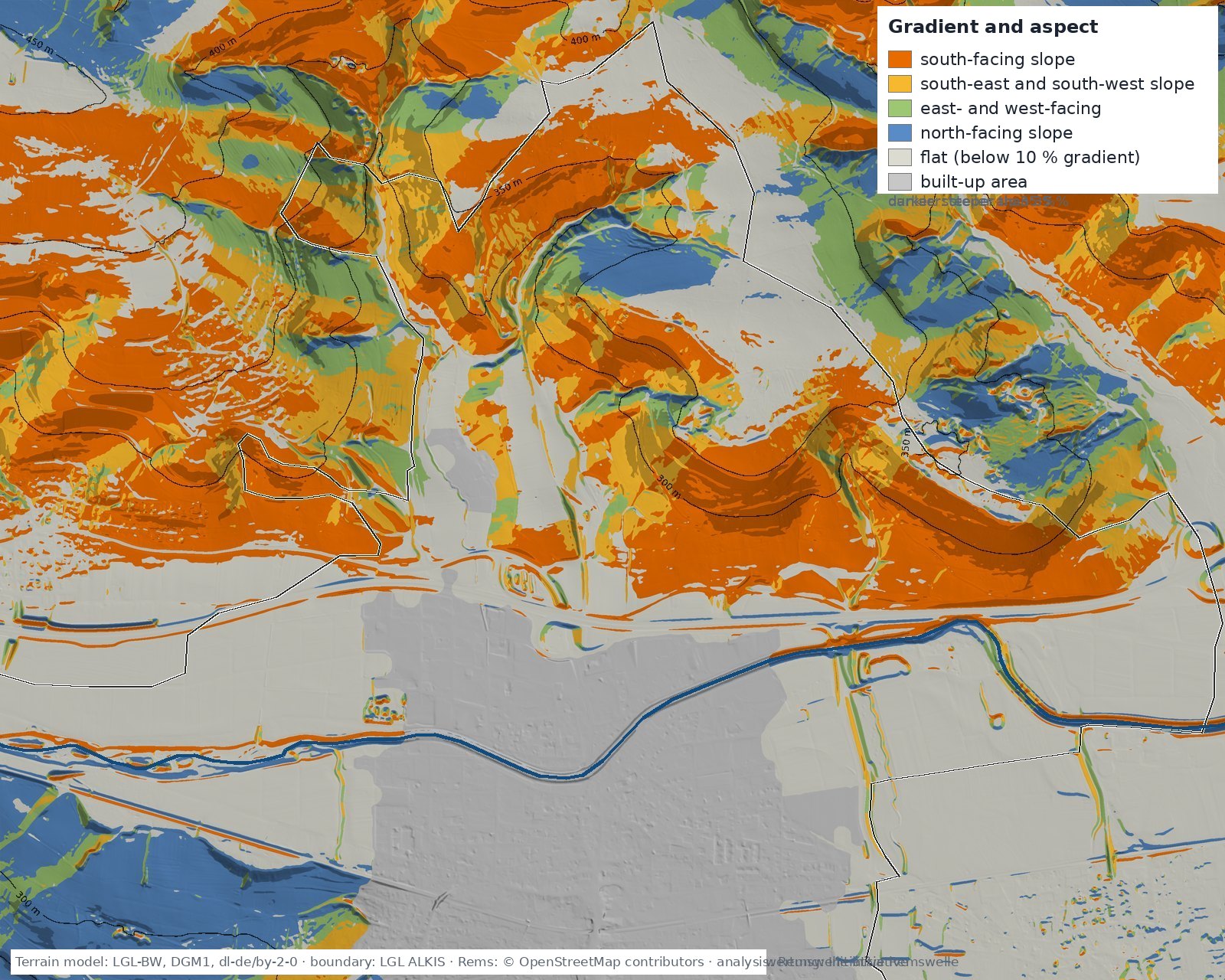
The result: outside the built-up area the Hungerberg side has about 115 hectares of south-facing slope with a gradient of 10 to 35 per cent – the classic vineyard gradient, steep enough for sun and cold-air drainage, gentle enough to work. Almost half of it, a good 50 hectares, lies in the lowest band between 240 and 280 metres, directly above the village; 20 to 25 hectares each follow in the bands up to 320 and up to 360 metres, almost 15 hectares between 360 and 400 metres, and above that nothing – the Hungerberg runs out at the top. Add about 37 hectares of south-facing slope steeper than 35 per cent: the old terraced sites that could only be worked with walls. North-facing slopes on this side of the valley amount to just 35 hectares, east- and west-facing ones to 18.
What does that mean for the vineyard of tomorrow? A thought experiment, not an expert report: the air gets about 0.6 degrees cooler per 100 metres of altitude. If the climate warms by two degrees, the climate the vineyard used to have at 300 metres is found about 300 metres higher – and the Hungerberg is not that high. So viticulture here cannot simply migrate up the slope. It can migrate round the corner: east- and west-facing sites that used to be too cool become interesting, and the hottest south-facing sites just above the village become rather too warm and too dry for Trollinger and Riesling, but all the more suitable for heat-loving varieties. On the Hungerberg the shift would therefore be less one of altitude than one of varieties and aspect. And the cold air plays its part: the cool nights that flow from the slope into the village are the same ones that leave the grapes their acidity. → Cool air for Winterbach · → The Rems is getting warmer · → Vineyards of tomorrow on the Hungerberg
What this means for the Remswelle
The Remswelle is to be built at a crossing that has been one for a thousand years: here the salt road crossed the river, here lay royal estate and castles, here the weir later protected the valley from floods. A place by the water where people meet would be nothing new for Winterbach – only the wave would be. → The site
Frequently asked questions
Was there a castle in Winterbach?
Yes, even two: a small castle in the Burgklinge north of the Rems, whose mound survives and appears in the terrain model as a spur with plateau and neck ditch, and a motte in the middle of the village, mentioned in 1400 and levelled when the quarter was rebuilt.
Did the salt road pass through Winterbach?
According to the Heimatverein Winterbach, the Hofhäusle on the Hungerberg lay on the old salt road from Schwäbisch Hall to Esslingen; it crossed the Rems at Winterbach and climbed over the Pflasterweg to the Engelberg. The exact course on the Hungerberg is not recorded; the terrain model suggests, as a hypothesis, a sunken lane from the edge of the village over the Hof into the Burgklinge.
What is a Triebgraben?
The boundary fortification of the forest pasture: a ditch, a steep bank or a wall between forest and field or vineyard, so that cattle grazing in the forest did not stray into the crops. On the Hungerberg it is partly preserved along the forest edge; in the terrain model it appears as a ditch with a steep scarp uphill and a low bank downhill.
Were the Celts in Winterbach?
The Heimatverein shows on the Rohrbronner field the site of a Celtic fortification with a visible defensive ditch. In the terrain model an artificial ditch on the municipal boundary can be seen there; whether it belongs to a fortification is undecided. No scientific dating has been published.
Was there wine-growing in Winterbach in the past?
Yes. The cadastral map of 1832 shows about 90 hectares of vineyards on the south slope of the Hungerberg in the Winterbach district. Today, according to OpenStreetMap, about 5 hectares remain; the other sites became meadow orchards, gardens, woodland and housing.
What is a hillshade (Schummerung)?
A depiction of the terrain in which an imaginary light falls obliquely onto the digital elevation model: slopes facing the light appear bright, slopes in shadow dark. The terrain looks three-dimensional and even small edges, ditches and banks become visible – under forest too, because the trees are removed from the model. The German word comes from "schummern", shading with a pencil, which is how map draughtsmen once depicted mountains.
What is a lynchet?
A step in the ground at a plot boundary on a slope, created by centuries of ploughing: the soil creeps downhill within each plot and collects at its lower edge, while the unworked balk keeps its level. On the Hungerberg such steps still trace the vineyard strips of the 1832 cadastral map.
Sources: Aerial photographs 1953, 1968, 1978, 1993, 2008 (historical orthophotos) and digital orthophoto: LGL-BW (2026), dl-de/by-2-0 · Vineyards 1832: historical cadastral map 1:2500 (as of 1832), LGL-BW (2026), dl-de/by-2-0, analysis of the vine symbols: Remswelle initiative; vineyards today: © OpenStreetMap contributors (landuse=vineyard, as of 30.09.2026) · Wikipedia, "Burg Winterbach" and "Turmhügelburg Winterbach" (accessed 29.09.2026), after Walter Wannenwetsch in: Die Burgen im Rems-Murr-Kreis (1994) · Heimatverein Winterbach e. V., "Kulturgeschichtliche Wege um den Hungerberg", leaflet and folder (2019, Remstal Garden Show) · Heimatverein Winterbach e. V., "Steinbrecher in Winterbach" (05.04.2021) · LUBW, register of area natural monuments (Rems-Murr district), based on data from the Environmental Information System (UIS) of the LUBW · LGL Baden-Württemberg, digital terrain model DGM1 and DGM025, digital orthophoto and historical cadastral map 1:2500, as of 1832, Data licence Germany – attribution 2.0; analysis: Remswelle initiative · OpenStreetMap contributors (ODbL), entries Gruhe, Hof-Halle, Königstein, tracks and paths (accessed 29.09.2026) · Homöopathischer Verein Winterbach und Umgebung e. V., chronicle of the association
Last updated: 15 October 2026 · Initiative Remswelle