
Rems and Winterbach · River, water, nature and history
Vineyards of tomorrow on the Hungerberg
The Hungerberg was a vineyard. In 1832 vines stood on around 90 hectares in the Winterbach municipality alone; today about 5 remain. The vineyards became orchards, gardens and forest. We traced this on Traces in the Hungerberg with the cadastral map, aerial photographs and the terrain model. Here we look ahead: the climate is getting warmer, and with it changes where, and with which varieties, viticulture can succeed. We play this through as a thought experiment, with the same tools we used for the past.
1832 – vineyards up to the forest edge · 1953 to today – the forest grows down the slope · today – steps and terraces in the terrain · around 2045 – a climate like the Kaiserstuhl has today
How many factors decide on a vineyard
Whether good wine can grow on a slope does not depend on one number. We distinguish two steps. First, areas drop out where viticulture is out of the question or would first have to be clarified: protected areas and protected habitats, forest and buildings, hollows where cold air collects at night and frost threatens in spring, and very steep slopes. On all remaining areas many factors work together, and none decides on its own.
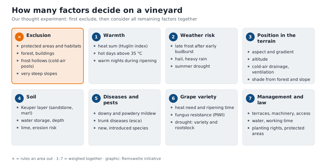
Some factors work against each other. A warm south slope ripens grapes earlier but also buds earlier – and is then vulnerable to late frost. Warm nights in autumn raise the sugar but lower the acidity that gives a wine freshness. An airy slope dries the leaves faster and keeps fungal diseases in check; a sheltered hollow is damp and warm. And new pests arrive with the climate and global trade: the spotted-wing drosophila, for instance, which pierces ripe grapes, comes from East Asia and has only been widespread in Germany for a little over ten years.
Warmth today and tomorrow: the Huglin index
How much warmth a grape variety needs is measured by winegrowers with the Huglin index. From April to September it adds up, for every day, how far the daily mean and maximum lie above 10 degrees, and takes the longer summer days in the north into account. The higher the value, the later-ripening the varieties that will ripen. The viticulture researcher Pierre Huglin gave thresholds for this:
| Huglin index | Varieties that then ripen reliably (selection) |
|---|---|
| about 1,500 | Müller-Thurgau |
| about 1,600 | Pinot blanc |
| about 1,700 | Riesling, Chardonnay, Pinot noir |
| about 1,800 | Cabernet franc |
| about 1,900 | Merlot, Cabernet Sauvignon |
| about 2,100 | Syrah, Grenache |
For the Hungerberg we calculated the index from weather data since 1991 and projected it with seven climate models for the years 2041 to 2050. The maps show the index for every 10-metre point of the slope; only altitude is taken into account, because it gets cooler further up.
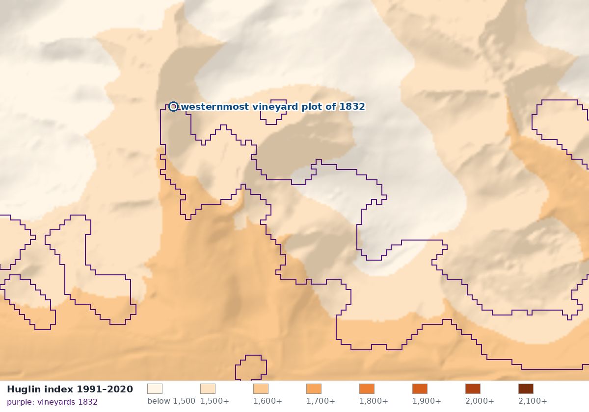
1991–2020: on the slope the Huglin index is mostly 1,500 to 1,700 – enough for Müller-Thurgau and Pinot blanc, borderline for Riesling.
The westernmost vineyard plot of 1832 on the Hungerberg – Bordeaux climate in the Böhnlöchle?
Right at the top of the forest edge in the Böhnlöchle lay the westernmost vineyard plot on the Hungerberg in 1832. Today it is a traditional orchard meadow. The plot lies at 317 metres, has a gradient of 35 percent and faces west-southwest. What would ripen there in future?
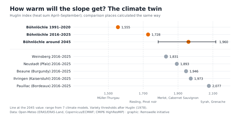
On average in 1991–2020 the Huglin index there was about 1,550 – Müller-Thurgau climate. In the last ten years it was already about 1,730, as much as Weinsberg had twenty years ago. Around 2045 the climate models suggest about 1,960. That is roughly the warmth the Kaiserstuhl and Burgundy have had over the last ten years, and about what Bordeaux had on average from 1991 to 2020. Climatically, varieties such as Merlot or Cabernet Sauvignon would then come into question, while it would tend to become too warm for Riesling.
The soil shows where vines stood
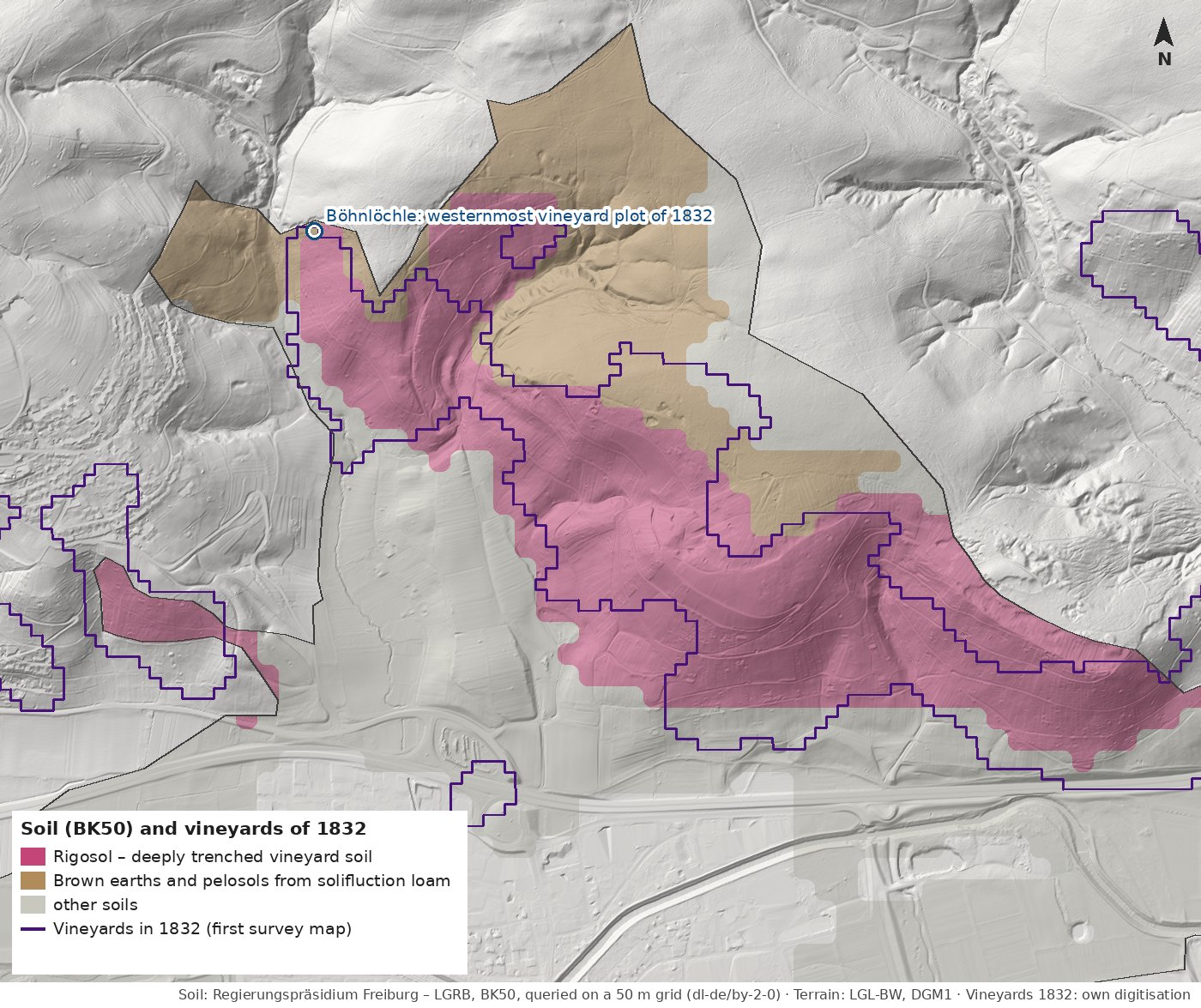
The soil map of the State Office for Geology, Raw Materials and Mining records Rigosol over large parts of the Hungerberg. Soil scientists use this name for a soil created by deep digging – trenching, with which winegrowers turned the soil deeply before planting. We queried the soil map on a 50-metre grid and compared it with the vineyards of the first survey map of 1832: about three quarters of the vineyard area of that time lies on Rigosol, and conversely a good 70 percent of the Rigosol in the municipal area lies where vines stood in 1832. Even where orchards, gardens or forest grow today, the vineyard soil has remained.
What is a Rigosol – and what is "trenching"? In German it is called rigolen: digging the soil very deeply with spade or plough, 40 centimetres to more than a metre depending on the source, turning and mixing it as you go. The word comes from French. In viticulture this was done before every new planting, often every 20 to 40 years: the soil was loosened so the vines could root deeply, and mixed with rock fragments from below, with manure and often with marl that winegrowers fetched from marl pits. → Traces in the Hungerberg The natural soil with its layers becomes a mixed layer reaching down about a metre. After rigolen, soil scientists call this soil a Rigosol.
What "remained" means. A natural soil takes thousands of years to form its layers. A century of meadow or forest therefore does not undo the trenching: the mixed layer is still there. On the Hungerberg, according to the State Office's description, that means calcareous right from the surface – because marl was brought up from below –, stony with sandstone grit, deep but clayey. It is not especially fertile: the State Office rates its natural fertility as moderate. It is a soil that people made for vines.
Made for vines – and good for orchards and lean meadows today. According to the State Office's ratings, the Rigosol on the Hungerberg has strengths of its own: it can be rooted deeply, so standard fruit trees reach water further down in dry summers. It is calcareous and neutral to slightly alkaline, which fruit trees like. It filters pollutants highly to very highly. And as a site for near-natural vegetation it is rated high – precisely because it is rather lean, warm and dry, it suits species-rich lean meadows with many flowers and wild bees. Only as a sponge is it of little use: as a "balancing body in the water cycle" it is rated low under meadow and field, the soil at the forest edge above it moderate. So that rain still soaks in instead of running off, it needs a closed sward. → Forest or meadow? · → Sponge landscape
How to read the map: Red is the Rigosol, brown are soils that were not trenched. The purple line encloses the vineyards of 1832. Where red and line coincide, viticulture has reshaped the soil. Because we only queried the map on a 50-metre grid, the edges are coarse.
The Böhnlöchle lies exactly on the boundary. At the westernmost vineyard plot of 1832 the Rigosol ends. Downhill lies the typical vineyard soil of the Rems valley: according to the State Office's description moderately deep to deep, calcareous from the surface, clayey-loamy with sandstone grit, slightly alkaline to neutral. It stores a low to moderate amount of water for plants (70 to 120 millimetres) and lets it through only very poorly. Uphill, towards the forest edge, a pelosol brown earth from loess-bearing solifluction loam begins: mostly free of lime and moderately acidic in the top metre, with more water (90 to 160 millimetres), waterlogged in places below. According to the map, forest and grassland dominate there.
What this means for vines. The calcareous Rigosol is the soil on which wine has grown in the Rems valley for centuries. Storing only a moderate amount of water slows the growth of the vines – that can benefit the grapes, but in hot, dry summers it can lead to drought stress, and those are becoming more frequent. Because the dense soil absorbs rain poorly, water easily runs off the steep slope at the surface; green cover between the rows keeps soil and water on the slope. The soil at the forest edge above is cooler, wetter and more acidic – less typical for vines. → Why slopes slide · → For comparison: Böhnlöchle and Höffenklinge
And Bordeaux? There, too, the soil helps decide which variety grows where. In the Médoc, for example in Pauillac, there are warm, well-drained gravel soils – Cabernet Sauvignon dominates there. In Pomerol the soils are particularly rich in clay; they hold water and cool the vines, and Merlot dominates there, as it does on the limestone of Saint-Émilion, where Cabernet Franc also thrives. There is no gravel in the Böhnlöchle, but there is clayey, calcareous Keuper. If the climate there allows Bordeaux varieties around 2045, the soil would point to Merlot or Cabernet Franc rather than Cabernet Sauvignon. This remains a thought experiment: the soil map has a scale of 1:50,000, and it cannot replace a soil sample on site.
What a model does not know
Our thought experiment calculates with warmth and terrain. Much of what decides a wine is not in it:
- The vintage. A wet summer, hail, a late frost – in a single year the weather counts, not the average.
- The microclimate. The weather model is coarse. On the slope it is locally warmer or cooler than the calculation shows; cold air collects in the hollows at night, which the map does not show. → Cool air for Winterbach
- The soil. Whether a slope lies on Stubensandstein or on marl, how much water it holds and how quickly it warms shapes the wine. The warmth maps do not include it; for the Böhnlöchle we have read it from the soil map above.
- The diseases. Warmth brings not only ripeness but also new fungi and pests. Fungus-resistant varieties, known as PIWI varieties, are therefore becoming more important.
- The craft. Whether good grapes become a good wine is decided by the winegrower.
Viticulture has shifted here before
The change is not new. From the early 19th century fruit trees replaced many of the vines on the Hungerberg, around 1910 phylloxera reached Winterbach too, and after the Second World War many plots became gardens and weekend plots. In future the climate could provide new reasons to think about vines on the slope – and about other varieties than those known here.
Anyone wanting to plant a vineyard today needs a permit, by the way: in the European Union new vineyards may only be planted with an authorisation for new plantings since 2016. And on the Hungerberg there are also the landscape protection area, the bird protection area and protected habitats – lean meadows, orchards and dry-stone walls have their own value. → Forest or meadow? · → From vineyard to forest
What this means for the Remswelle
For a wave in the Rems we read the same landscape: how the terrain steers water and air, how warm it gets, what changes. Anyone who looks at the slope this closely also understands the river below it better. → The Rems at Winterbach
Frequently asked questions
What is the Huglin index?
A heat sum for viticulture. For every day from April to September it counts how far the daily mean and maximum lie above 10 degrees; the sum is adjusted slightly by latitude. The higher the value, the later-ripening the grape varieties that will ripen.
Will Merlot grow in Winterbach in future?
Climatically it could be warm enough on the Hungerberg around 2045 for Merlot or Cabernet Sauvignon to ripen. Whether anyone plants it, whether it would be permitted and whether the wine would be good is another question – our calculation is a thought experiment.
What are PIWI varieties?
Fungus-resistant grape varieties. They have been bred to be more resistant to downy and powdery mildew and to need less plant protection. With warmer, humid summers they are becoming more interesting for many sites.
Why do you only calculate with altitude?
Because altitude is the influence we can put into numbers most reliably: going up, it gets cooler by about 0.65 degrees per 100 metres on average. Aspect, forest shade and cold air also have a strong effect but cannot be converted into a heat value so easily. We therefore describe them for the example plot in the text.
How we calculated: Huglin index from daily values from Open-Meteo (ERA5 and ERA5-Land reanalysis) for 1991–2025, calculated the same way for every place and period, with Huglin's latitude factor. For the future we added the change in seven climate models (CMIP6, HighResMIP) for 2041–2050 to the observed values, once relative to 1991–2020 and once to 2016–2025, and took the mean of both calculations; the range shows the differences between the models. For the map we converted the value at the example plot to the altitude of every point at 0.65 degrees per 100 metres (DGM1 of the State Office, 10-metre grid).
Do grapevines need bees?
Hardly. Cultivated vines have hermaphrodite flowers in which male and female organs are united; they are about 98 per cent self-fertilising, with a little help from the wind. Bees and other insects still visit the vine flowers, mainly for the pollen – for the yield they play hardly any role. The wild grapevine, the ancestral form, is different: it is dioecious, male and female flowers sit on different plants, and insects carry the pollen. In Germany it is considered threatened with extinction and grows only in the Rhine floodplains. How honeybees and wild bees compete for flowers on the Hungerberg: → Too many bees?
Sources: Open-Meteo, Historical Weather API (ERA5/ERA5-Land, Copernicus Climate Change Service, ECMWF) and Climate API (CMIP6 HighResMIP: CMCC-CM2-VHR4, FGOALS-f3-H, HiRAM-SIT-HR, MRI-AGCM3-2-S, EC-Earth3P-HR, MPI-ESM1-2-XR, NICAM16-8S), accessed 01.10.2026 – own analysis · P. Huglin (1978): Nouveau mode d'évaluation des possibilités héliothermiques d'un milieu viticole, Comptes Rendus de l'Académie d'Agriculture de France · Terrain model DGM1 and historical cadastral map 1:2500 (1832): LGL-BW (2026), dl-de/by-2-0 · Regulation (EU) No 1308/2013, authorisation scheme for vine plantings from 2016 · Municipality of Winterbach, local history (phylloxera 1910/11) · Heimatverein Winterbach e. V., "Kulturgeschichtliche Wege um den Hungerberg" (2019) · wein.plus glossary, "hermaphroditic flower" (self-fertilisation of cultivated vines) · Wikipedia (German), "Wilde Weinrebe" (accessed 03.10.2026) · Data source: Regierungspräsidium Freiburg – LGRB, soil map 1:50,000 (BK50) with the descriptions of map units L262 (pelosol-rigosol and rigosol from solifluction loam) and L533 (pelosol brown earth from solifluction loam), queried 14.10.2026 on a 50-metre grid, dl-de/by-2-0; comparison with the vineyards of 1832: own analysis · Spektrum Lexikon der Geographie, "Rigosol"; DWDS, "rigolen"; Saxon State Office for Environment, Agriculture and Geology, Rigosol fact sheet (vineyard soil) · iDealwine, "The terroirs of Bordeaux" (soils and varieties in the Médoc, Pomerol and Saint-Émilion)
Last updated: 15 October 2026 · Initiative Remswelle