
Rems and Winterbach · River, water, nature and history
The riddle of the rafting chute
Somewhere in the old Winterbach mill weir there was an opening through which, at every drift, the water shot and the wood passed: the rafting chute (Floßgasse). It is the most exciting place in our whole search – because if a standing wave ever stood anywhere on the Rems at rafting flow, then most likely here, where a lot of water had to pass through a narrow gap. The problem: nobody today knows what the chute looked like. The good news: the files about it exist. This is chapter 3 of our search → The forgotten wave of Winterbach.
Clue 1: a mention from 1660
The oldest trace leads deep into the 17th century: the Winterbach rafting chute is spoken of in the files in 1660 – decades before regular drifting began. That fits the millers' ordinance of 1627, which already assumes chutes in the mill weirs of the Rems. Winterbach had its chute early – presumably because the Remsmühle on the mill race was one of the valley's important mills. → Historic course of the Rems
Clue 2: the inventory of 1736
When the treasury set up a "permanent rafting operation" in 1736, a commission travelled the river and listed the existing structures. On the Rems, counted upstream: main rack and timber yard at Neckarrems, then "rafting chutes at Großheppach, Winterbach, Schorndorf, Plüderhausen and Waldhausen". At that point the Winterbach chute was not a plan but existing stock – it was inspected and taken over for the new operation.
Clue 3: a file with our name on it
Searching the online finding aids of the Baden-Württemberg State Archives, we came across an entry that electrified us. In the Ludwigsburg State Archives, in the holdings of the Württemberg timber administrations, under shelfmark F 120 Bü 153, lies an archival unit of its own titled:
"Floßgasse zu Winterbach" (rafting chute at Winterbach) – dated 1799 and 1852, two documents.
Two documents is not much. But 1852 is the late period of operation – ten years before the drift ended. It may well contain a condition report, a repair, perhaps a sketch. We will inspect the file and report what we find. The same holdings contain thick collective files – "Description of the rafting installations" (1833–1881) and "Survey of the rafting installations" (1754–1852) – where Winterbach may appear as well.
Clue 4: the survey of 1862
Perhaps the best trace comes from the very end of rafting. When the last drift ran in 1862, the state wanted to keep all its rights open – and had "all rafting chutes very carefully measured and drawn". For the mills of the neighbouring towns, such records with site plans are listed in the finding aids: Schorndorf, Rudersberg, Plüderhausen, Haubersbronn, Großheppach, Beinstein, Waiblingen, Neckarrems. The coloured 1862 plan of the Schorndorf chute is even reproduced in the research literature. Whether such a plan exists for Winterbach, we do not yet know – the corresponding series of the Welzheim rafting inspectorate has no Winterbach entry, which fits the question of whether the chute was still in use at all in 1862. The 1852 file may answer that too.
Where did the chute sit?
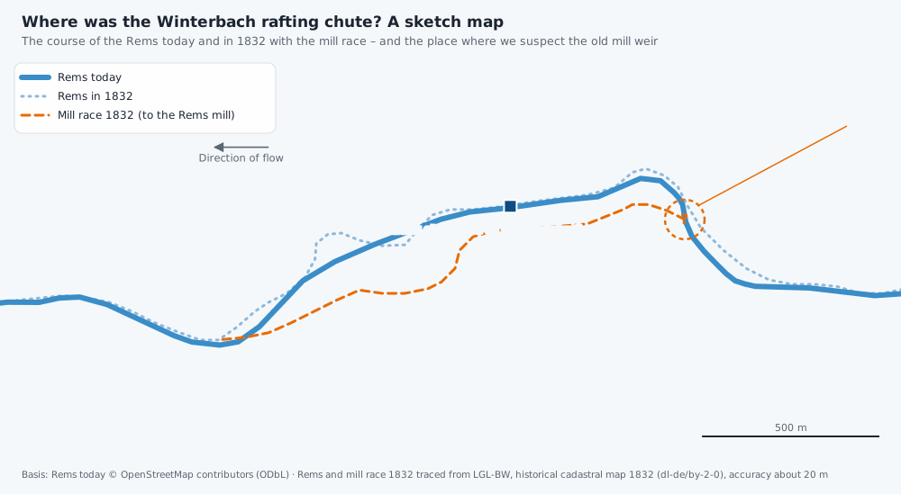
The chute sat in the mill weir – but where did that stand? Our earlier analysis of the 1832 cadastral map suggests that the old Winterbach mill weir stood where the mill race branched off the Rems in the bend before the Remsknie – roughly at the site of today's small sill, next to which the field names "Wehräcker" and "Wehrwäsle" (weir acres, weir meadow) lie. In 1960 the old weir was demolished as part of the flood-relief works and the mill race filled in. If this reading is right, then the rafting water once shot through the chute exactly where walkers stand at the little step today – and where we observe the many sticklebacks. The precise location is not documented; it is one of the things we want to settle with the files. → Historic course of the Rems · → Flood protection on the Rems
Could a wave stand there?
The physics is the same as for any river wave: where fast, shallow water passes into slow, deep water, a hydraulic jump forms – and with the right geometry, a standing wave. → How a standing wave forms A rafting chute concentrated considerable amounts of water onto a few metres' width at rafting flow, with a drop across the weir. Whether that produced a smooth slide, a choppy rapid or a true wave depends on details we do not know: width, length, slope, downstream water level. That is exactly why we are looking for the plans. Only once a geometry is on the table can one calculate – before that, any statement would be a guess, and guessing is not what these pages do.
Frequently asked questions
What exactly was a rafting chute?
An opening in the mill weir – usually closable with stop logs – through which the drifting wood, together with the water, was guided past the weir. During the drift the boards were pulled, the mill stood idle, and the wood shot through the chute with the water. At some chutes a day labourer was posted to prevent jams.
Can the file be inspected?
Yes. Archival unit F 120 Bü 153 is listed in the online finding aid of the Baden-Württemberg State Archives and can be inspected at the Ludwigsburg State Archives or ordered as a reproduction. That is precisely what we intend to do – and we will report the outcome here.
Why does the chute matter for the Remswelle?
Not as a model for the technology – a modern wave is built differently. But as history: it shows that Winterbach once had, for centuries, a built structure in the river that harnessed the power of the water. And it is the most concrete spot where the question "was there ever a wave here?" becomes researchable instead of speculative.
Does today's small sill stand on the old weir?
We consider that plausible; it is not documented. The 1832 map, the field names and the location of the mill-race offtake point that way. Only files and old construction plans can bring certainty – which is what the archive research is for. Anyone who knows old photographs or records of the Winterbach mill weir will find our contact details in the Impressum (German).
Sources: Uwe Jens Wandel, "Zur Flößerei auf Rems und Wieslauf", in: Waiblingen in Vergangenheit und Gegenwart, vol. 9 (1987), pp. 177–195 (the 1660 mention, the 1736 inventory, the post-1862 survey, reproduction of the 1862 Schorndorf plan) · Baden-Württemberg State Archives, Ludwigsburg State Archives, F 120 Bü 153 "Floßgasse zu Winterbach", 1799/1852 (permalink (opens in a new tab)); F 120 Bü 137/138 (description and survey of the rafting installations); F 119/2 Welzheim rafting inspectorate, section "Mills, weirs, rafting chutes" (online finding aids, consulted 13 October 2026) · Cadastral map NO XXVIII 29 (1832), LGL-BW · → Historic course of the Rems
Last updated: 15 October 2026 · Initiative Remswelle