
Rems and Winterbach · River, water, nature and history
The restoration of the Rems at Winterbach
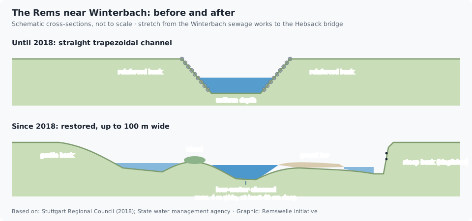
Between the Winterbach treatment plant and the Hebsack bridge, the Rems had flowed since the river corrections of the 1930s and 1950s in a straight channel of even depth with reinforced banks – engineers call it a trapezoidal profile. In 2018 the state of Baden-Württemberg rebuilt this section over about 1.1 kilometres: the Rems may now find its own way across a width of up to 100 metres, with islands, gravel bars, steep and shallow banks and side channels. At about 3.5 million euros it was at the time the largest active river restoration in the Stuttgart administrative region. The section lies about two and a half to three kilometres downstream of the site of the Remswelle.
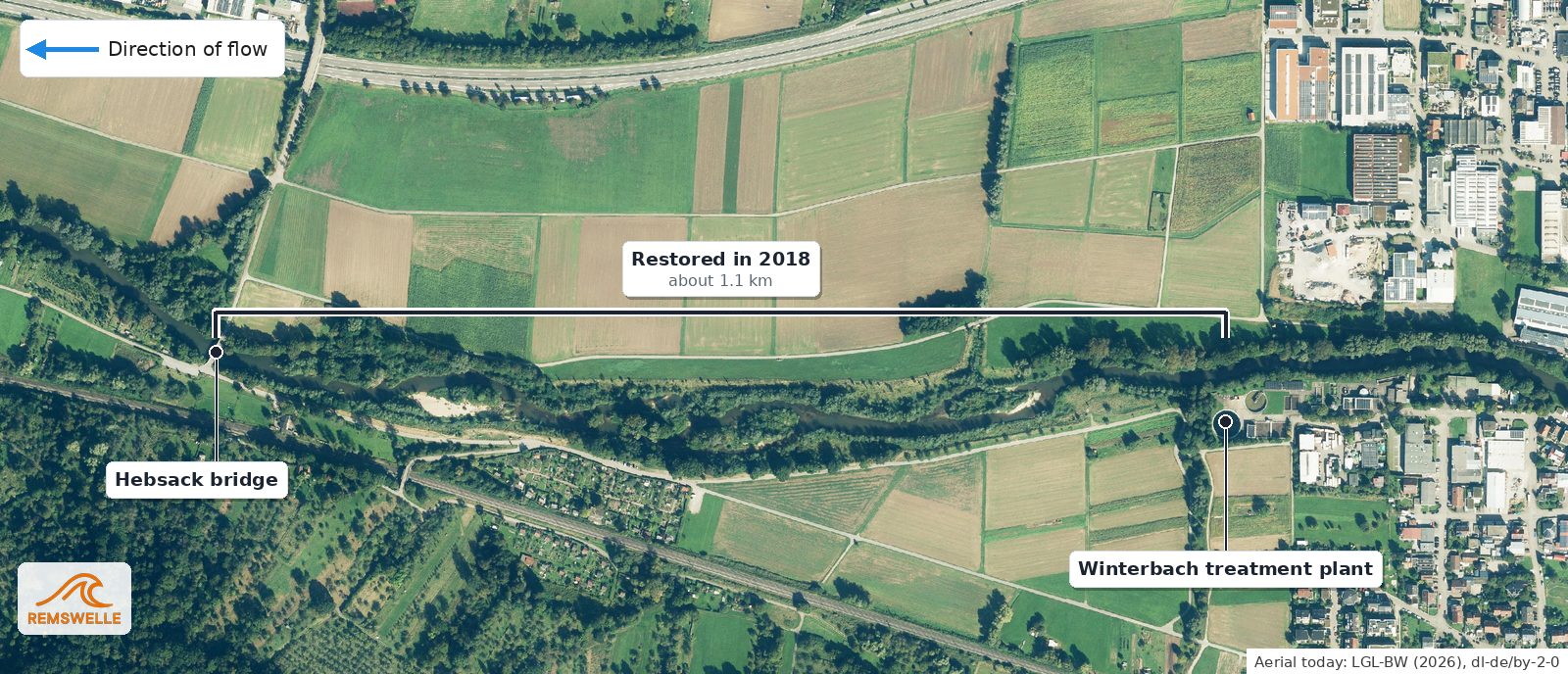
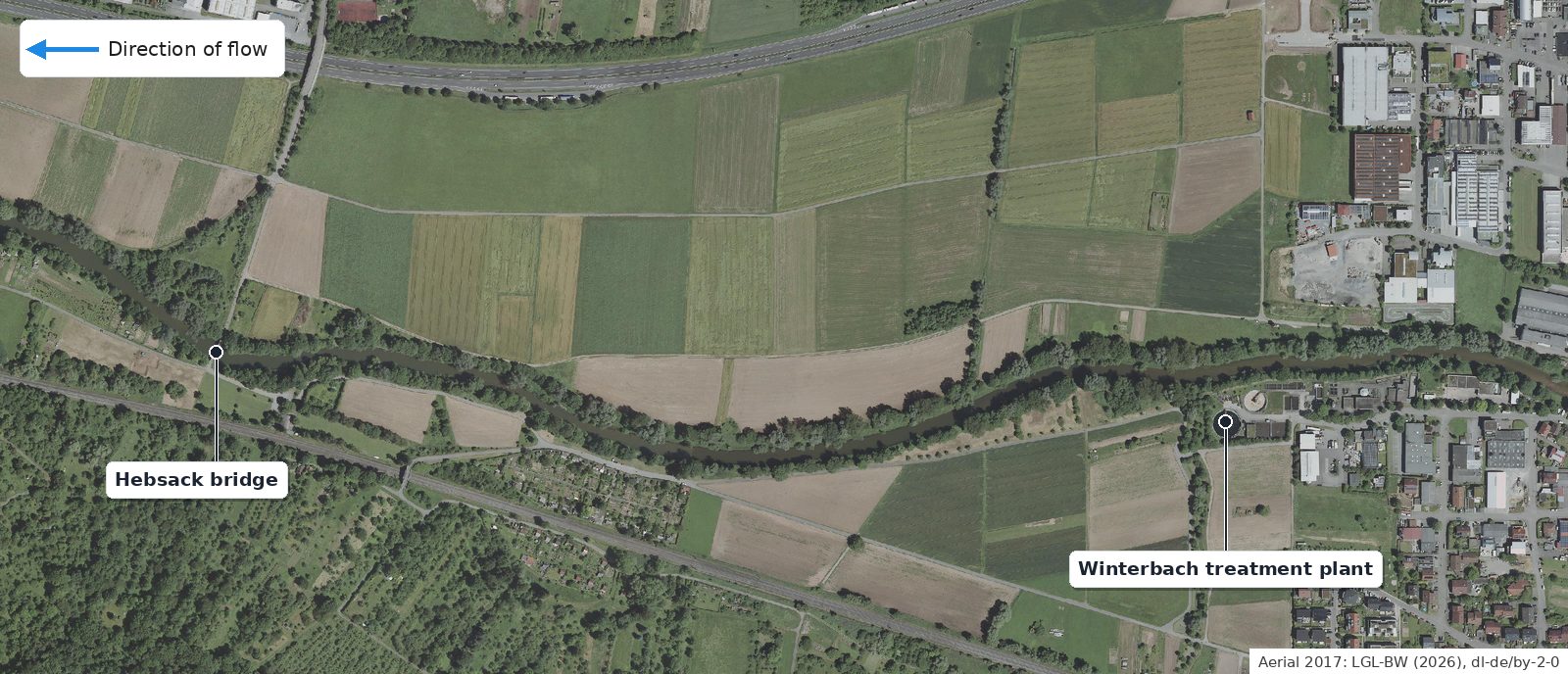
Before and after: 2017 and today
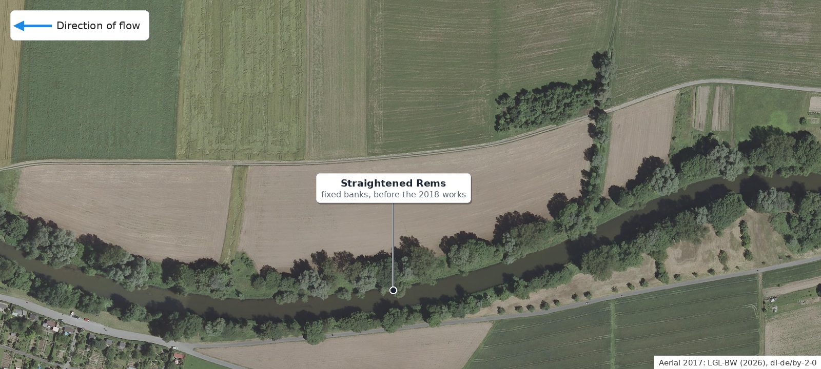
How much the section has changed is shown by two aerial photographs from the state survey: 2017, one year before the works, and today. The curly bracket marks the restored section between the Hebsack bridge and the treatment plant.
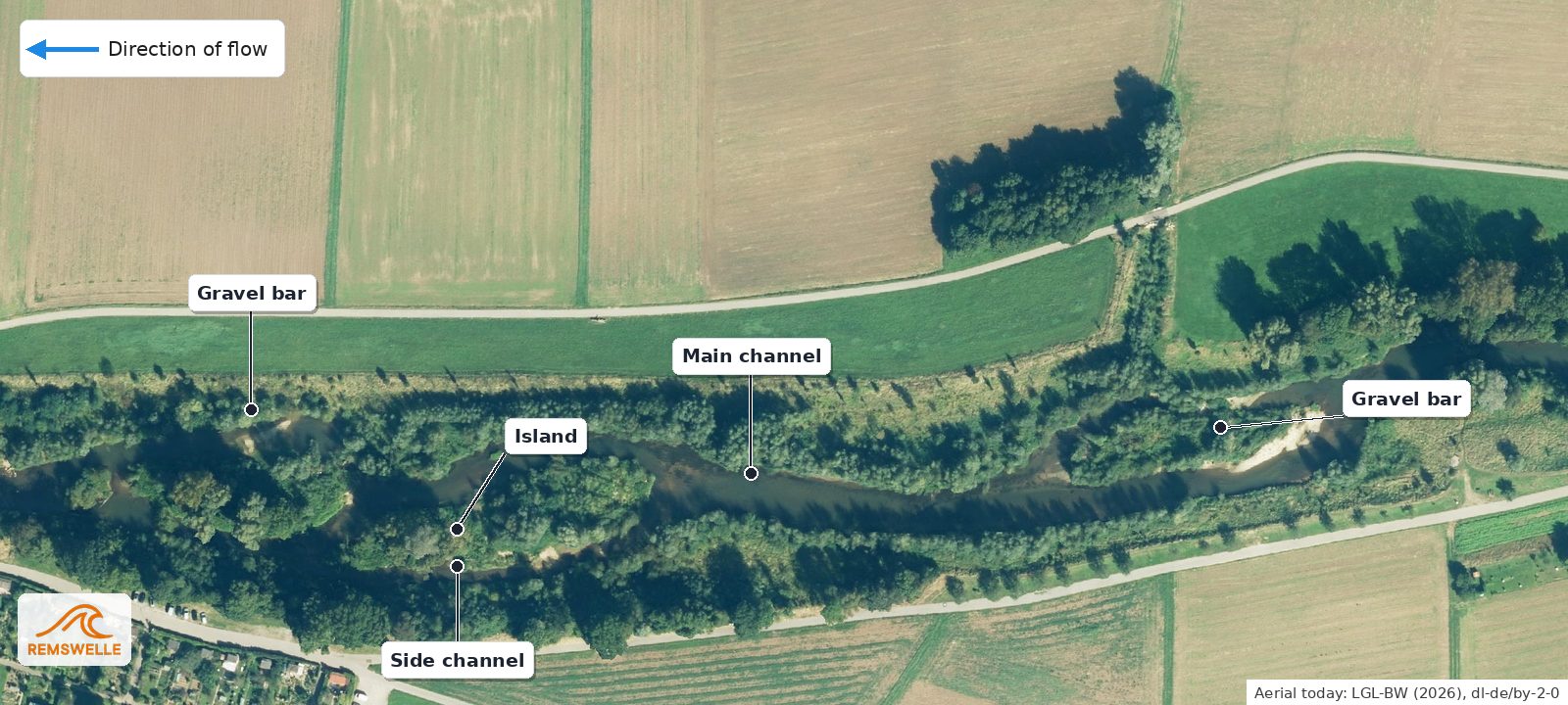
The middle part deserves a closer look. Where a straight canal ran between two embankments in 2017, the Rems now splits into a main and a side arm with a vegetated island between them, and gravel bars form on the inside of the bends.
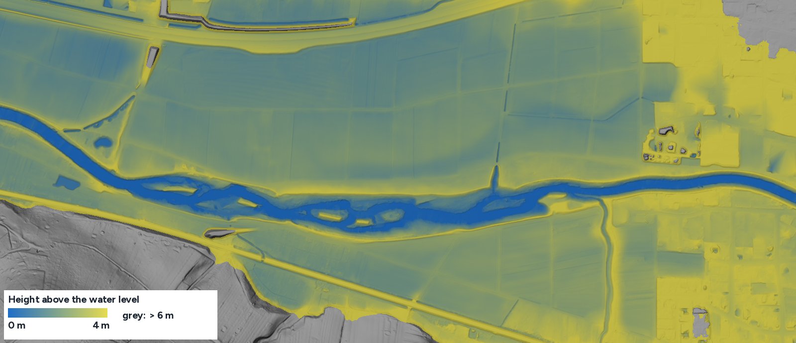
What the terrain model shows. In the state terrain model (as of 2023) you can see what stays hidden under water and vegetation in the aerial photo: in the middle section the river bed is more than twice as wide as upstream and downstream, with islands, side channels and shallow banks just above the water level. Upstream and downstream the Rems remains a narrow, uniform channel.
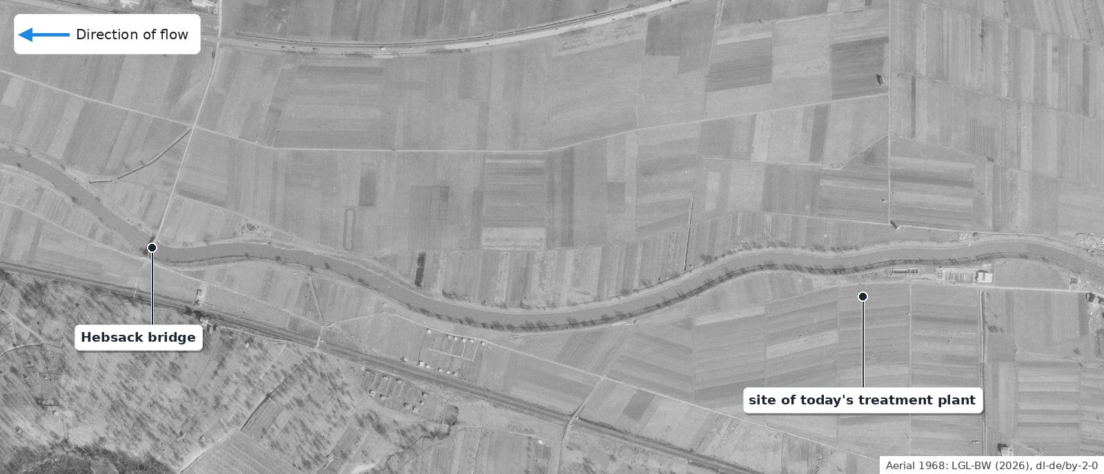
Already in 1968 the Rems ran here in an evenly wide, confined bed with gentle bends and a row of trees on the north bank. Narrow strips of fields and meadows reached right up to the river; the treatment plant did not yet exist.
How the Rems used to flow here
The Württemberg cadastral map of 1832 shows the Rems in this section as a single, winding course – with clearly more bends than today, but without any side arms drawn in. The 1851 description of the Oberamt of Schorndorf calls the river bed "mostly shallow and sandy, about 4–7 feet deep", roughly one to two metres, and notes that floods "are not rare in spring and summer". A shallow, sandy river that often overflows its banks keeps shifting its bed – which is exactly what the restoration now allows again within limits. The Regierungspräsidium explicitly names side and old-arm structures as a goal; the construction company describes "several side arms and islands".
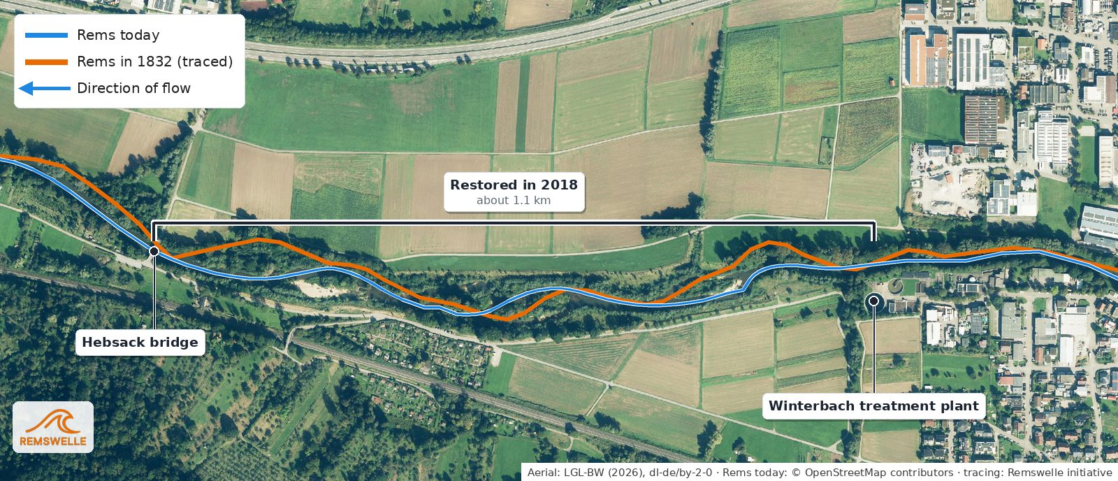
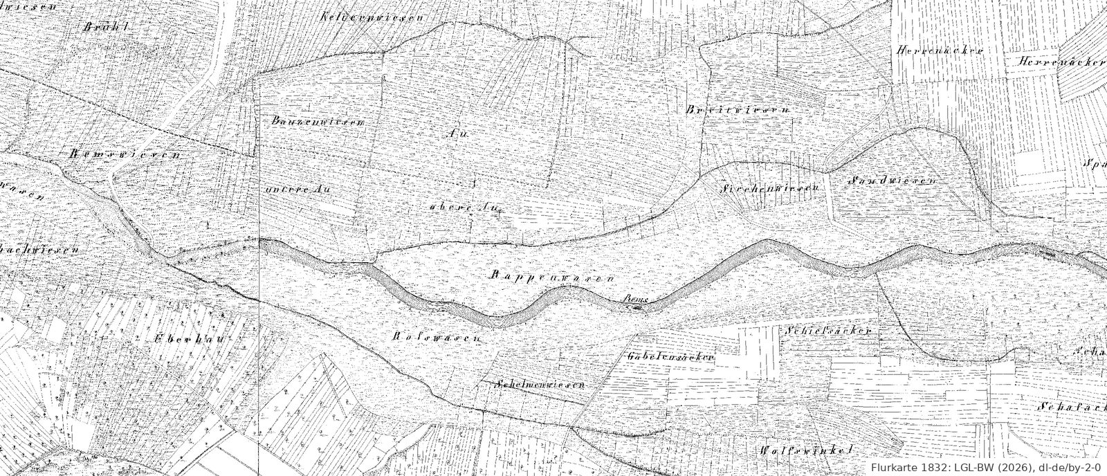
We traced the orange line by hand on the cadastral map; it is accurate to about 20 to 40 metres. Whether there were oxbows or dead river loops in the floodplain before 1832, the map does not show. → The historic course of the Rems
What the field names tell
Long before aerial photographs, people named their meadows and fields after what they found there. The names are still recorded in the official land register – and along the Rems almost all of them tell of water. We explain the German names, as they appear on the map.
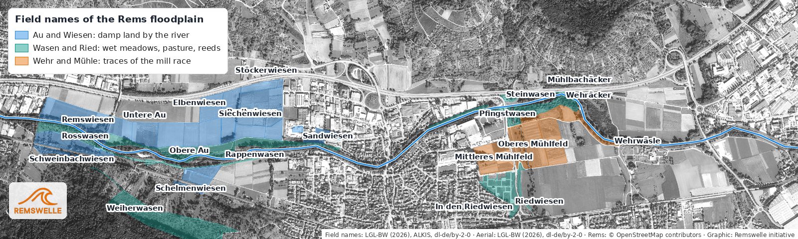
Au – the restored section contains the Untere Au and Obere Au (lower and upper Au). An Aue is flat, damp land by the water that floods at high water – exactly what the section is for again today. Wiesen (meadows) – Remswiesen, Breitwiesen, Sandwiesen: land by the river was too wet for fields and was used as meadow. The Sandwiesen (sand meadows) fit the 1851 description of a "shallow and sandy" river bed. Wasen – Rosswasen, Rappenwasen, Weiherwasen, further upstream Pfingstwasen and Steinwasen. A Wasen is a damp grassy area, often common pasture; the Rosswasen was, by its name, a horse pasture, and the Pfingstwasen, according to the Grimm dictionary, a meadow spared until Whitsun (Pfingsten) and then opened for grazing. Ried – the Riedwiesen in the east recall reeds and marsh. Wehr and Mühle (weir and mill) – Wehräcker, Wehrwäsle, Mühlbachäcker and Mühlfeld at the Remsknie lie exactly where the 1832 map shows the mill race. → The historic course of the Rems
For some names the origin is not clear. The Siechenwiesen probably belonged to a Siechenhaus, a home for the sick outside the village; we have not found proof of this for Winterbach.
What was built
Ground was broken on 15 February 2018, and construction ran from February to October 2018. The client was the Stuttgart Regional Council (Regierungspräsidium) with the state agency for watercourses (Landesbetrieb Gewässer); planning was coordinated with the Rems Water Board (Wasserverband Rems). In six sections the bank reinforcements were removed and the bed widened. Deflector groynes and boulders create varied currents, islands and gravel bars provide spawning grounds and resting places. Ice-age gravel from the site itself was used. A low-water channel no more than four metres wide and at least 40 centimetres deep keeps the section passable for fish even when there is little water; pools offer larger fish deep places, quiet bays shelter the young fish. About half of the existing trees and shrubs were kept, and the cycle path was moved. For the Remstal Garden Show 2019 the section was one of the nature destinations in the Rems valley.
Who lives here
On the information boards along the Rems, the state agency for watercourses presents three characteristic species: the barbel, a fish of fast-flowing rivers that spawns on shallow gravel; the kingfisher, which breeds in steep banks without vegetation; and the water frog. Shortly after construction was finished, the press reported kingfishers at new nesting burrows. In March 2022 conservationists and the lower nature conservation authority found clear beaver signs in the restored area; in 2023 probably two beavers lived here. After the flood in June 2024 the responsible beaver adviser feared the animals had been washed away – in April 2025 beavers were back.
Because the kingfisher is sensitive to disturbance, there are quiet zones on the right bank, and the state agency asks visitors to be considerate. Dog owners are asked to keep their dogs on a lead.
More Rems in Plüderhausen and Urbach
In autumn 2018 a second section followed in Plüderhausen: about 400 metres, about 400,000 euros, with flattened banks, islands and groynes. When the Plüderhausen/Urbach retention basin was built, a further 400 metres or so were given a near-natural design, with steep banks for the kingfisher.
What this means for the Remswelle
The restoration shows what value the Rems at Winterbach has today – for animals, plants and for the people who walk here. A Remswelle must fit into this development and must not endanger what has been achieved. The site does not lie in the restored section but at the outlet structure upstream, where the banks are reinforced anyway. Even so: fish passage is a condition, not a bargaining chip, and the feasibility assessment must also clarify what a wave would change downstream. → Wildlife and plants on the Rems · → Ecology and permits
Frequently asked questions
Where was the Rems restored in Winterbach?
Between the Winterbach treatment plant and the Hebsack bridge on the boundary with Remshalden, over about 1.1 kilometres.
When was the Rems restored in Winterbach?
Construction ran from February to October 2018; in 2019 the section was part of the Remstal Garden Show.
Did the Rems have side arms here in the past?
The 1832 cadastral map shows a single, winding course without side arms. According to the 1851 description of the Oberamt, the river bed was shallow and sandy and often overflowed; such rivers keep shifting their bed. Today's side arms and islands were created deliberately in 2018.
What do the field names along the Rems mean?
Au, Wiesen, Wasen and Ried stand for damp, often flooded land by the river; Wehräcker, Wehrwäsle and Mühlbachäcker at the Remsknie recall the former mill race.
What did the restoration cost?
About 3.5 million euros; the state bore the majority.
Are there beavers on the Rems in Winterbach?
Yes. Beaver signs have been documented in the restored section since March 2022; after the 2024 flood the animals had disappeared for a time, and in April 2025 they were back.
Sources: Regierungspräsidium Stuttgart, "Die Rems fließt wieder", 19.12.2018; "Neue Beschilderung für mehr Rücksicht auf die Natur an der Rems in Winterbach", 18.12.2020; press release Plüderhausen, 21.12.2018 · Wolff & Müller, "Wolff & Müller renaturiert die Rems" · Stuttgarter Nachrichten, "Renaturierung bei Winterbach: Die Rems ist kaum wiederzuerkennen" (2018) · Zeitungsverlag Waiblingen: beaver signs (March 2022), 08.03.2023, April 2025; approx. August 2018 (Plüderhausen/Urbach basin) · VVS, "Remsnaturierung Winterbach" (accessed 26.09.2026) · Beschreibung des Oberamts Schorndorf (description of the Oberamt of Schorndorf), Stuttgart 1851 (Wikisource), chapter A (waters) · LGL Baden-Württemberg: historic cadastral map of Württemberg (sheet Winterbach, as of 1832), aerial photographs 1968 and 2017, digital orthophoto, land register ALKIS (field names), Datenlizenz Deutschland – Namensnennung 2.0 · Wikipedia, "Wasen (Toponym)"; Wiktionary, "Aue"; Grimm, Deutsches Wörterbuch, "Pfingstweide" (accessed 27.09.2026)
Last updated: 15 October 2026 · Initiative Remswelle