
Rems and Winterbach · River, water, nature and history
The network of flushing ponds
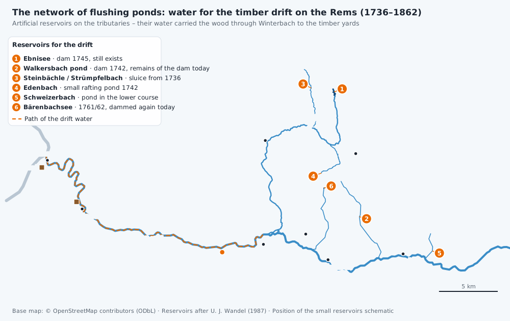
The Rems does not carry enough water of its own to float timber for days on end – the ducal officials knew that. Their solution was as simple as it was radical: they built artificial ponds on the tributaries, filled them over winter and snowmelt – and released the water on purpose for the drift. Flushing ponds (Schwellseen) these reservoirs were called; the literature speaks of surge rafting. Every drop from them flowed through Winterbach. This is chapter 2 of our search → The forgotten wave of Winterbach.
The Ebnisee: a 115-metre dam for firewood
The best-known flushing pond still exists: the Ebnisee in the Welzheim Forest, today a popular destination. It was built for the drift. A smaller predecessor already appears on the forest map of 1686; the great dam was built in 1745: around 115 metres long, 8.6 metres high, with three timber channels through which the stored water was released via a hoisting mechanism in the pond keeper's hut. The district description of 1845 describes how the pond was "swelled for the purpose of timber floating" – mostly from autumn to spring – and gives an area of about 42 morgen.
Operation was seasonal: after the drift, the pond bed was leased out as meadow. And it was expensive – the first major repair of the dam was due as early as 1761, and in 1820 a dam failure was feared. When rafting ended in 1862 the pond was drained, and only refilled some twenty years later. Few of the families strolling around it today suspect they are circling a drift reservoir.
The Walkersbach pond: botched construction, anno 1743
The second large reservoir lay in the Walkersbach valley between Lorch and Plüderhausen: dam built in 1742, 87 metres long, 8.6 metres high. Its story reads like a cautionary tale: in October 1743 a stretch of about 45 metres collapsed into the pond, and more followed in spring 1744 – the contractor had done poor work. An engineer lieutenant supervised the repair and in the process drew a precise plan of the old and new dams that survives in the files to this day. The 1752 repair ended up costing a multiple of the original construction price. Remains of the "Seedamm" are still clearly visible in the terrain.
Here too there was conflict with the millers: the owner of the Walkersmühle complained in 1779 that the water was withheld from him "two, more often three, four, five weeks" – he could not mill. The officials' answer was cool: the rafting right had been there before the mill.
The smaller siblings
Besides the two large ponds the files name smaller reservoirs: in the Steinbächle (Strümpfelbach) valley (sluice from 1736), on the Edenbach near the Laufenmühle (small pond, 1742), on the Schweizerbach, and – last and most expensive – the Bärenbach pond of 1761/62. All these streams join the Rems upstream of Winterbach: the Schweizerbach at Lorch, the Walkersbach between Lorch and Plüderhausen, the Bärenbach at Plüderhausen, the Wieslauf with the Ebnisee at Schorndorf. Whatever was released – it came through Winterbach. The Steinbächle sluice survives, and the Bärenbach pond is impounded once again today.
Surge then – sponge now
One can admire the network of flushing ponds: it was water management with the means of the 18th century, planned, built and operated for 120 years. But it was the opposite of what does a river good. Water was collected in order to be driven through in a few days; the mills stood idle, the fish fry suffered, and after the drift the water was gone. Today we think exactly the other way round: a landscape with deep soils, meadows, hedges and functioning floodplains holds water back and releases it slowly – supporting the Rems in dry weeks, a little every day, instead of three days of force. That is why we plan no surge operation for the Remswelle, from any reservoir. The flushing ponds remain what they are: an impressive piece of history. → More flow for the Rems · → Sponge landscape Winterbach
Frequently asked questions
Can you visit the flushing ponds today?
The Ebnisee yes – it is one of the most popular destinations in the Welzheim Forest, with a circular path. Remains of the Walkersbach dam stand in the valley south of Walkersbach, the Steinbächle sluice survives, and the Bärenbach pond is impounded again. Anyone walking there is walking through the infrastructure of the old drift.
How much water did the Ebnisee hold?
The files give a capacity of around 1.5 million buckets (Eimer) for the 1745 dam – a good 400,000 cubic metres in Württemberg measure, which fits the recorded pond area of about 42 morgen well. According to the operating reports, the water lasted for about five to six days of rafting; at the Walkersbach pond it was two to three days.
Did the pond releases create a flood wave?
For drift systems in other regions – the Karwendel, for instance – the sources expressly distinguish "fore-water" from the "flood wave of the main water". For the Rems no such steep front is documented: the reservoirs could also release their water gradually over days, and waves flatten over a long distance. What arrived in Winterbach, we do not know – yet.
Why not build flushing ponds today for more surfable days?
Because water released in surges harms a river and benefits nobody for long – the drift itself showed that. Water law, ecology, flood protection and safety rightly stand against it today. The sustainable route runs through the landscape: soils and land that hold water and release it slowly. → More flow for the Rems
Sources: Uwe Jens Wandel, "Zur Flößerei auf Rems und Wieslauf", in: Waiblingen in Vergangenheit und Gegenwart, vol. 9 (1987), pp. 177–195 (dam dimensions, repairs, the mill dispute, the small ponds) · Beschreibung des Oberamts Welzheim, Stuttgart 1845, chapter A 2 (Wikisource): Ebnisee and Walkersbach pond · Carla Fandrey, "Auf Holzwegen im Schwäbischen Wald. Der Ebnisee und die Schwallflößerei", in: Schlösser Baden-Württemberg 4 (2002) · Ebnisee association: history of the lake · Documentation of the Karwendel drift (karwendel.org): "flood wave of the main water" · → When the Rems carried firewood
Last updated: 15 October 2026 · Initiative Remswelle