
Rems and Winterbach · River, water, nature and history
When this was sea – how the Rems valley came to be
Winterbach lies about 245 metres above sea level. Yet half an hour's drive away, at Holzmaden on the edge of the Swabian Alb, people find ichthyosaurs, sea lilies and ammonites from a sea that covered the whole of southern Germany 183 million years ago. How does that fit together? And could the sea come back one day? This page tells how the valley in which the Remswelle is to run came into being – and why its slopes are the way they are.
The valley in layers
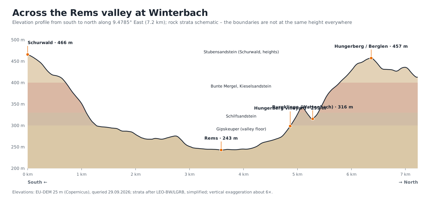
The Rems valley at Winterbach is a Keuper valley. The Keuper is an epoch of about 30 million years at the end of the Triassic (roughly 235 to 200 million years ago) in which clay marl, gypsum and sandstone were deposited here layer by layer – sometimes in shallow lagoons, sometimes in river deltas, sometimes in dried-out salt pans. These layers now lie almost horizontally on top of one another, and the Rems has cut down through them from above. Anyone climbing from the river to the Schurwald or the Hungerberg therefore walks upwards through earth history:
- Valley floor: Gipskeuper. At Winterbach the Rems flows in the Gipskeuper, as the state's regional encyclopaedia records: through the northern half of the municipality, at the foot of the Berglen hills, the Rems flows "in its narrowing Gipskeuper valley". Gipskeuper is a soft, colourful clay marl with gypsum layers – easily eroded, hence the wide valley, and prone to swelling, hence the restless ground at the foot of the slopes.
- Lower slopes: Schilfsandstein and Bunte Mergel. Above the Gipskeuper follows a sandstone bed, the Schilfsandstein, laid down in the channels of a river delta; above it the Bunte Mergel, clay marl again. Sandstone over clay marl – this pairing decides where springs emerge and where slopes slide.
- Upper slopes and heights: Stubensandstein. The Schurwald south of the Rems is a Stubensandstein plateau: "to the south the district reaches up onto the Stubensandstein of the Schurwald." Sandstones also crop out on the Hungerberg; the former quarry the Heimatverein shows on its cultural history trails is a Stubensandstein quarry.
- Right at the top: Knollenmergel and Lias. Manolzweiler lies "on a ridge above Knollenmergel, in the area of the interrupted Lias escarpment" – there the Jurassic already begins, the same period as the marine fossils of Holzmaden.
How the sea came to Holzmaden – and left again
The strata visible on the slopes today formed close to sea level. In the Triassic and Jurassic, southern Germany was a flat, slowly subsiding basin on the edge of an ocean; rivers carried sand and mud into it, and at times the sea pushed far inland. The Posidonia Shale of Holzmaden – Lower Jurassic, about 183 million years old – is the mud of such a sea floor, in which ichthyosaurs and sea lilies were preserved so well because there was hardly any oxygen at the bottom.
That Holzmaden now lies about 400 metres and the Alb 700 to 1,000 metres above the sea has two causes that must be kept apart. First, sea level was higher then than today, because there were no polar ice caps and the ocean basins held less water owing to more active ridges on the sea floor. Second – and this is the larger share – the land was uplifted later: with the folding of the Alps, from the Tertiary onwards, the whole of southern Germany was raised and tilted slightly to the south-east. Only then did the escarpments of Keuper and Jurassic form, and only then could the Neckar and the Rems cut into the old marine deposits. So the Rems valley is young: it is the work of a river that has been working its way for a few million years through the deposits of a much older sea. At Winterbach the Rems now lies more than 200 metres below the Schurwald heights – that is how much the river has cleared away here.
Will the sea ever come back?
The idea that sea level could one day rise as far as Winterbach is tempting – and physically impossible. The sea can only rise as far as there is water. All the ice on Earth together corresponds to about 66 metres: Antarctica about 58 metres, Greenland a good 7 metres, all the mountain glaciers of the world together only about 30 centimetres. Add the expansion of warming water, a few metres in a very warm climate. Even a completely ice-free Earth would therefore put the sea roughly 70 to 80 metres higher – not 245. The scenarios of the Intergovernmental Panel on Climate Change for the year 2100 are about 0.3 to 1 metre, for the centuries after that a few metres.
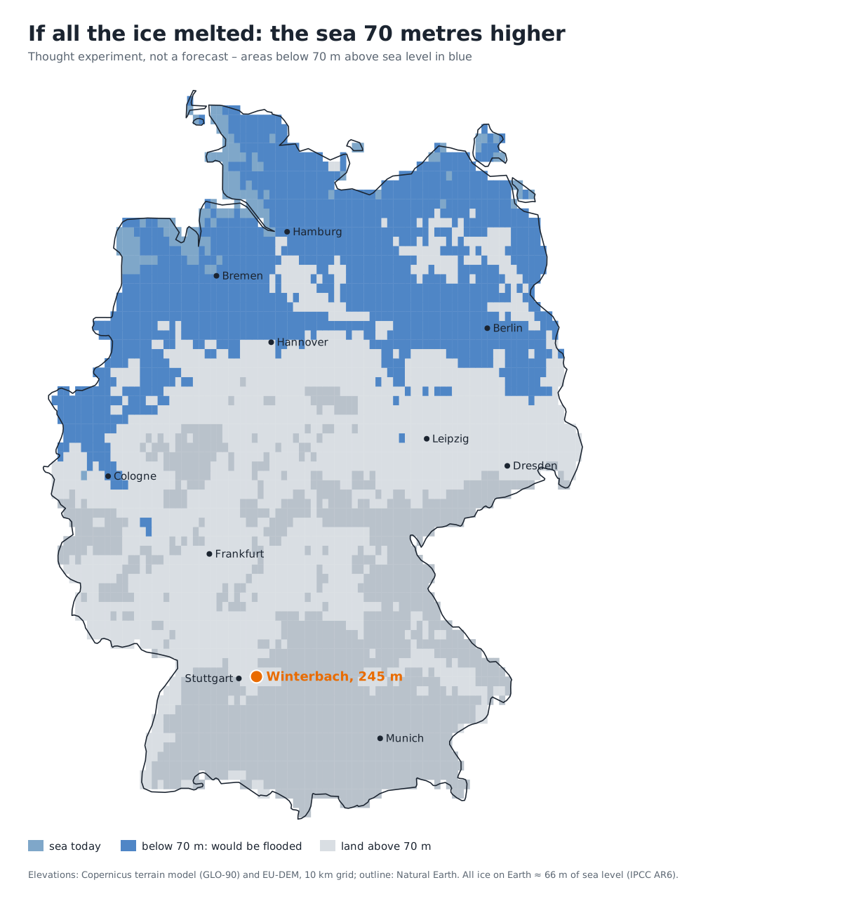
The thought experiment nevertheless shows something: the North German Plain, Hamburg, Bremen and large parts of Lower Saxony would be under water, Berlin by the sea. Winterbach would not. For us in the Rems valley, climate change means something else: a warmer Rems, drier summers, heavier downpours. → The Rems is getting warmer · → Flood protection on the Rems
Why slopes slide in the Keuper
Sandstone over clay marl is a shaky combination. Rain seeps into the fissured sandstone, banks up on the dense marl beneath and emerges on the slope as a spring – this is how the spring horizons formed that earned Winterbach "the best spring water in the Rems valley". → Springs and hillside water When the marl soaks through after long rain, it softens and becomes a sliding surface: the sandstone above breaks into slabs and slides.
How quickly that can happen, the Rems valley experienced at Urbach on 7 April 2001. At the Kirchsteig above the village an entire hillside slid within about 80 minutes: the scarp was about 240 metres long and up to 17 metres high, the earth masses flowed 200 metres downhill, 3.2 hectares with about 100 plots and several leisure huts were affected. Geologically it was fissured Kieselsandstein of the Middle Keuper sliding on the Bunte Mergel – the same succession as on the slopes of the Rems valley. Since 2008 the landslide has been the nature reserve "Bergrutsch am Kirchsteig bei Urbach" and may not be entered because of continuing rockfalls and fissures. In Winterbach's neighbourhood the state also lists a natural monument with the telling name "spring-fed landslide slope in the Knollenmergel" – Knollenmergel is the most slide-prone layer of the whole Keuper.
The subsoil makes itself felt in the valley too: the floodplain soil of the Rems bears so little load that the ball-sports hall of the sports centre had to be founded on piles in 1995. → Cool air for Winterbach
Stone from the valley
What the river exposed, people used. On the Engelberg, on the Schurwald side, there were quarries and sand mills until well into the 20th century: hard quartz sandstone was broken into paving stones, fine white sand went to the masons, coarse brown sand to the plasterers. On the Hungerberg side the Heimatverein shows a former Stubensandstein quarry, today a natural monument, from which came the "Fleins" – very hard sandstone beds with which the winegrowers built their vineyard walls. And in the marl pits, called Kerfgruben in the Rems valley, they dug "virgin soil" for the vineyards. Even the Michaelskirche is earth history you can touch: built in 1309 as a fortified church of ashlar blocks, with churchyard walls that still stand today. → Traces in the Hungerberg
How high is what in Winterbach?
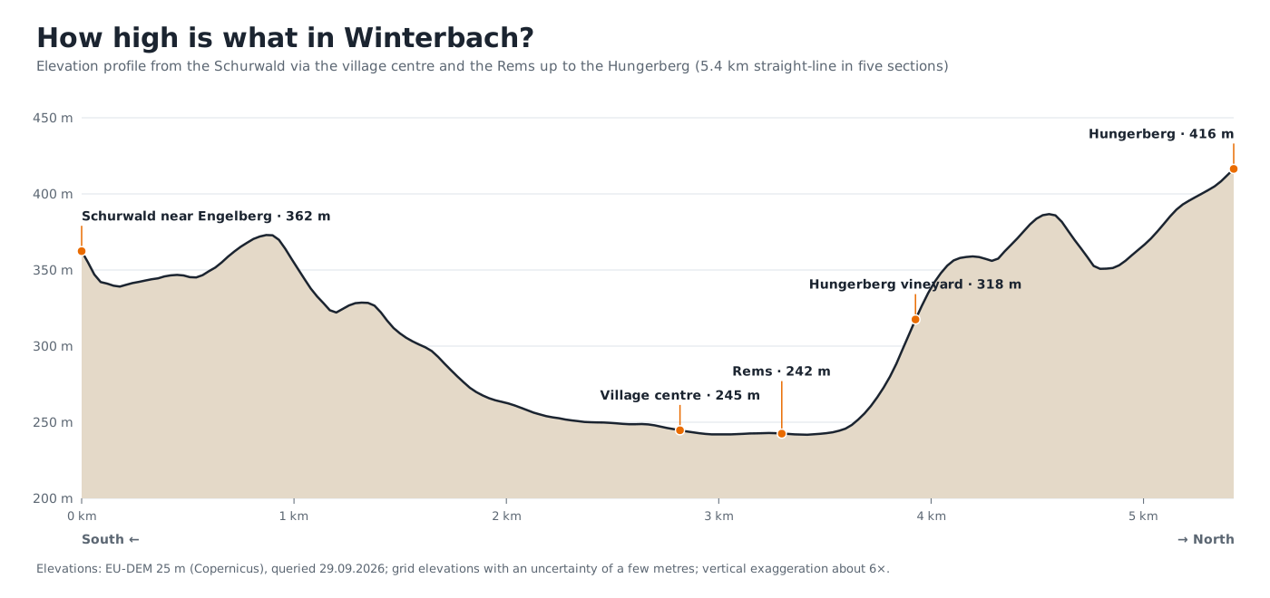
The village lies in the floodplain between 240 and 255 metres, barely ten metres above the Rems – which is why flood protection plays such a large role. To the north the Hungerberg rises by more than 170 metres within a kilometre and a half, to the south the Schurwald to over 460 metres. It is these valley flanks that send cool air down into the valley at night. → Cool air for Winterbach
What this means for the Remswelle
A river wave needs gradient and water – both are gifts of earth history. The Rems has gradient because the land was uplifted and the river cuts down; the water comes from a catchment whose Keuper slopes store rain and release it slowly. And the subsoil at the Remswehr – floodplain loam over Gipskeuper – is exactly what the feasibility study must examine before anyone builds. → Feasibility study · → The site
Frequently asked questions
Can sea level rise as far as Winterbach?
No. All the ice on Earth corresponds to about 66 metres of sea level; with the expansion of warmer water one arrives at roughly 70 to 80 metres. Winterbach lies about 245 metres above the sea. The IPCC scenarios for 2100 are about 0.3 to 1 metre.
Why are there marine fossils at Holzmaden if the sea never stood that high?
Because it was not the sea that stood so high but the land that lay so low. In the Jurassic, southern Germany was a shallow marine basin close to the sea level of the time. Only much later, with the folding of the Alps, was the land raised by hundreds of metres.
How high above sea level is Winterbach?
The village centre lies at about 241 metres at the market square and about 246 at the Michaelskirche, which stands on a slight rise; the Rems at about 238, the southern edge of the village at the foot of the Schurwald at about 250 metres; the Hungerberg rises to over 400, the Schurwald to over 460 metres.
Why do slopes slide in the Rems valley?
Because in the Keuper sandstone lies on clay marl. After long rain the marl soaks through and becomes a sliding surface, and the sandstone above slides off – as happened at Urbach in 2001.
What is the Schurwald made of?
Of Stubensandstein, a sandstone layer of the upper Keuper that forms a plateau south of the Rems; on the highest ridges near Manolzweiler follow Knollenmergel and the beginning of the Jurassic.
Sources: Landesarchiv Baden-Württemberg, LEO-BW encyclopaedia of places, "Winterbach (Remstal)" (natural region: Gipskeuper valley, Stubensandstein of the Schurwald, Lias escarpment above Knollenmergel) · LGRB State Office for Geology, Raw Materials and Mining, LGRBwissen "Keuperbergland" and "Stubensandstein" · Geotouren Schwarzwald, "Urbach: Bergrutsch-Rundweg" (landslide 07.04.2001, nature reserve since 2008) · IPCC, Sixth Assessment Report (AR6), Working Group I, Chapter 9 (sea-level scenarios, ice inventories) · Morlighem et al., BedMachine Antarctica (2020) and Greenland (2017); Farinotti et al., glacier volume (2019) · LUBW, register of natural monuments ("Ehemaliger Steinbruch", "Quelliger Rutschhang im Knollenmergel"), based on data from the Environmental Information System (UIS) of the LUBW · Heimatverein Winterbach e. V., "Kulturgeschichtliche Wege um den Hungerberg" (2019) and "Steinbrecher in Winterbach" (2021) · Georg Dehio, Handbuch der deutschen Kunstdenkmäler, Baden-Württemberg I (1993), Michaelskirche Winterbach · Elevations: Copernicus terrain model GLO-90 (Open-Meteo) and EU-DEM, own analysis; map of Germany: 10-kilometre grid, simplified
Last updated: 15 October 2026 · Initiative Remswelle