
Rems and Winterbach · River, water, nature and history
Flood protection on the Rems at Winterbach
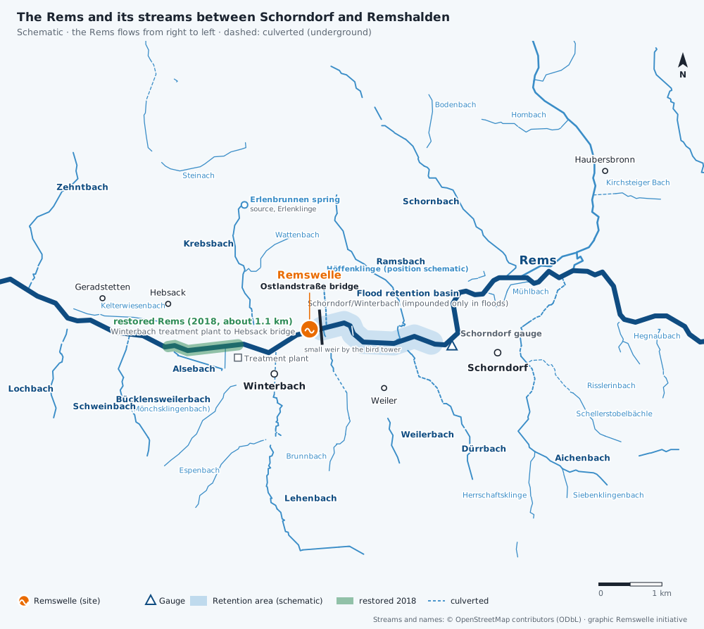
Winterbach is protected from Rems floods mainly by a structure that carries a road: the Ostlandstraße bridge. It is also the outlet structure of the Schorndorf/Winterbach flood retention basin, which the Rems Water Board (Wasserverband Rems) put into operation in 2005. If the Rems rises too high, the gates are closed here and the valley between Weiler and Winterbach fills with up to 1.17 million cubic metres of water. It is exactly at this structure that the Remswelle is to be built. That is why, for us, flood protection must not be impaired – anything else is out of the question.
The Rems Water Board
In February 1990 the Rems flooded large parts of the Rems valley between Lorch and Remshalden; according to the Water Board, the damage came to more than 20 million Deutschmarks. In 1993 the riparian municipalities formed a planning group, and a four-year study of the whole river basin identified nine sites for retention basins between Schwäbisch Gmünd and Weinstadt. In April 1998 the Rems Water Board was founded in Schorndorf. Its members are twelve municipalities from Essingen to Remseck am Neckar – Winterbach among them –, the Ostalbkreis and Rems-Murr-Kreis districts and the state of Baden-Württemberg, represented by the Stuttgart Regional Council (Regierungspräsidium). According to its own figures, the Water Board protects about 280,000 people in the Rems valley.
The retention basins on the Rems
| No. | Basin | in operation | Storage volume |
|---|---|---|---|
| 6 | Schorndorf/Winterbach | 2005 | 1.17 million m³ |
| 1 | Schwäbisch Gmünd/Reichenhof | 2006 | 769,000 m³ |
| 9 | Lorch/Waldhausen | 2008 | 761,000 m³ |
| 4 | Plüderhausen/Urbach | 2020 | 665,000 m³ |
Together the four basins hold back about 3.4 million cubic metres. A fifth, Urbach/Schorndorf, is planned but, according to newspaper reports, was on hold in 2024. The 2013 update of the concept provides for further basins. When the Plüderhausen/Urbach basin was built, the press reported a split of 70 per cent state and 30 per cent for the protected municipalities.
The Schorndorf/Winterbach basin
Construction began in September 2002, and on 21 October 2005 the basin went into operation as the Water Board's first; it cost about 14.3 million euros. The impoundment area covers about 62 hectares between Weiler and Winterbach. At normal water levels the Rems flows level through the outlet structure. According to the planning principles for the Rems basins, which the Regional Council presented at a specialist conference, the outlets should match the natural width of the watercourse, have a continuous natural bed and be passable for all aquatic organisms. In 2007 the journal WasserWirtschaft described it as an "eco-hydraulic outlet structure". During floods the gates are closed; volunteer dam wardens help to look after the installation.
Floods in Winterbach
Floods in Winterbach come from two directions: from the Rems when it rains for a long time over the whole catchment, and from the small streams when a thunderstorm breaks over the slopes. There have always been floods: the 1851 description of the Oberamt already notes that they "are not rare in spring and summer". In Waiblingen a flood mark recalls 1817, and the flood of 1882 long served as the yardstick. The Schorndorf gauge has measured the flow since 1931; the highest daily means date from 1956 and 1994.
| When | From where | What happened | What has helped since |
|---|---|---|---|
| Christmas 1919 | Rems | After thaw and persistent rain, the largest flood since 1882; the Schorndorfer Anzeiger reported on 29 December that Winterbach was completely under water | Straightening of the Rems in the 1930s and 1950s |
| 3 March 1956 | Rems | Highest daily flow at the Schorndorf gauge since measurements began: 230 cubic metres per second as a daily mean, about 1.8 times as much as in June 2024 | Flood clearance 1958–1968, Lehenbach reservoir 1963/64 |
| 13 April 1994 | Rems | 171 cubic metres per second as a daily mean at Schorndorf, the second-highest value since 1931 | Founding of the Rems Water Board in 1998 |
| February 1990 | Rems | Widespread flooding in the Rems valley between Lorch and Remshalden, damage over 20 million Deutschmarks | Founding of the Rems Water Board in 1998, retention basins |
| 21 March 2002 | Rems | Schorndorf gauge at 5.12 metres, almost the 100-year water level; B 29 flooded between Winterbach and Remshalden | Schorndorf/Winterbach basin, construction started the same year |
| 13 January 2011 | Rems | 5.22 metres at Schorndorf; the Schorndorf/Winterbach basin almost completely full | Basin in operation, filled almost to the brim |
| May 2016 | Rems (upper course) | Heavy rain over Schwäbisch Gmünd; the basins there filled up, the Winterbach one was not needed | Basins on the upper course |
| 1 to 3 June 2024 | Rems and streams | Schorndorf/Winterbach basin full to the brim twice; the Lehenbach pushed up manhole covers beneath the village centre, the Bücklensweilerbach flooded the underpass in Westergasse, Krebsbach and Wattenbach also overflowed. The district office had the restored floodplain flooded in a controlled way to relieve the basin. Fire brigade and THW deployed for over 48 hours | Basin, restoration as additional flood area, heavy-rain hazard maps |
| 19 July 2025 | Heavy rain, Lehenbach | About 40 litres per square metre in a short time; debris blocked the Lehenbach at the inlet to its culvert | – |
| 4 August 2025 | Heavy rain, Wattenbach | The Wattenbach was close to overflowing into the industrial estate, cellars flooded | Heavy-rain hazard maps (since 2025) |
HQ10, HQ100, HQextreme – what the figures mean
The state's flood hazard maps show which areas would be flooded in different floods. HQ10 and HQ100 are discharges that are statistically reached or exceeded once in 10 or 100 years respectively – which does not rule out their occurring several times in quick succession. HQextreme is a very rare event that also takes into account blocked bridges and the failure of protective structures. The maps can be viewed publicly in the LUBW map service.
How far the water would reach at HQ10, HQ100 and in an extreme flood can be compared on the flood map – choose the level at the top.
How high does the water rise?
With the slider you can explore which areas of Winterbach would be under water in a 10-year, 50-year and 100-year flood and in an extreme flood. The darker the blue, the more often an area is flooded. The switch also shows in orange which areas would be flooded in a 100-year flood without retention basins and flood defences – what these installations protect today.
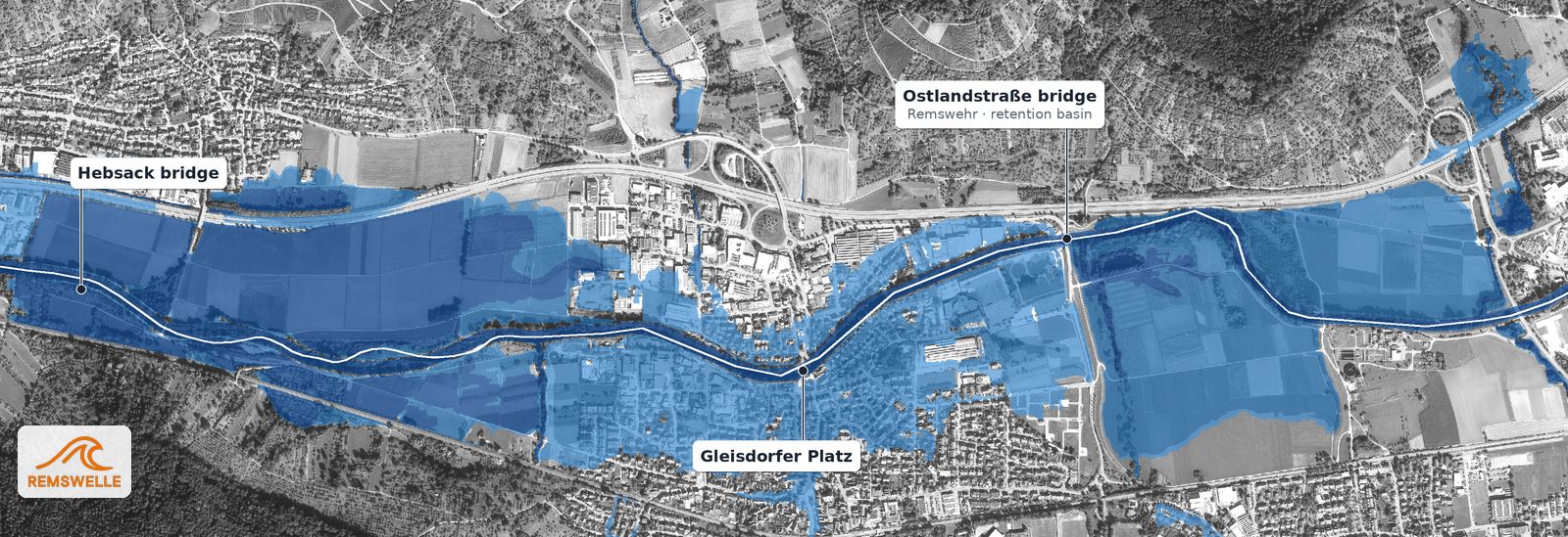
About every 100 years (HQ100): larger built-up areas south of the Rems and commercial areas to the north are under water as well.
Hatched orange: areas that would additionally be under water in a 100-year flood without the flood defences – the protected area.
The Lehenbach and its reservoir
Not every flood in Winterbach comes from the Rems. The Lehenbach comes down from the Schurwald and used to be called the Fleckenbach in the village. For a long time it ran openly through the upper village; today it flows to the Rems in a culvert beneath the village centre. In thunderstorms it can swell quickly. So Winterbach has always had two watercourses to protect itself from: the Rems and the Lehenbach.
The Lehenbach reservoir south of the village was built in 1963/64 as the municipality's flood retention basin, not as a bathing lake: an earth dam about 18 metres high that can hold back up to 452,000 cubic metres of flood water from a catchment of 5.8 square kilometres. A small permanent pool always remains in the basin. It is designed for a 100-year flood – more than forty years before the large basin on the Rems was built.
"Flood clearance": getting the water out of the village quickly (1958–1968)
The dam was not a stand-alone project. Between 1958 and 1968 Winterbach fundamentally reorganised the way it dealt with water. The Winterbach local filmmaker Willi Gramm recorded what was then summed up as "Hochwasserfreilegung" (flood clearance): the flood dam in the Lehenbach valley, the culverting of the upper Fleckenbach, the demolition of the Rems weir and the filling-in of the mill canal. This means the old weir where the mill canal branched off – not today's outlet structure on Ostlandstraße, which is also called the Rems weir locally. To remove this old weir, the municipality even gave up its own electricity generation in 1960: flood clearance and the improvement of the Rems mattered more to it than its own power station.
| When | What |
|---|---|
| into the 20th century | Lehenbach (Fleckenbach) flows openly through the upper village |
| Christmas 1919 | Major Rems flood, "the village of Winterbach was completely under water" |
| 3 March 1956 | Highest daily flow of the Rems since measurements began |
| 1958–1968 | Flood clearance: dam in the Lehenbach valley, culverting of the upper Fleckenbach, removal of the old Rems weir, filling-in of the mill canal |
| 1960 | Old Rems weir removed, end of the municipality's own power generation |
| 1963/64 | Lehenbach reservoir completed |
Which event directly triggered the dam and when it was decided we have not yet found; we welcome any hints. What is certain: it was part of a programme that began a few years after the great Rems flood of March 1956.
Then: drain quickly. Today: also hold back
Flood clearance followed the thinking of its time: get the water out of the village as fast as possible. It made Winterbach safer, and the dam and culvert still protect the village today. Since then a second idea has been added: holding water where it falls – in soils, meadows and floodplains – so that it drains more slowly and for longer. For us surfers this is more than a detail, because a wave does not need as much water as possible at once, but enough water for as long as possible. → What does all this have to do with surfing? · → Sponge landscape Winterbach
Heavy rain: the danger from the slopes
Floods do not only come from the Rems. In heavy rain, water runs from the slopes of the Schurwald and the Rems valley over roads and streams into the village. The Water Board has had heavy-rain hazard maps drawn up for all member municipalities; the maps for Winterbach were available in December 2024 and were presented publicly in the Lehenbachhalle in January 2025. In addition, the Lehenbach is held back by the municipality's reservoir south of the village. What the landscape itself can hold back – and why cisterns help less than many think – is on Sponge landscape Winterbach. → Heavy rain in Winterbach
What this means for the Remswelle
As surfers we check the gauge every day – and we know: when the Rems rises, the river comes first. A wave at the outlet structure must not obstruct flood discharge and must not impair the gates. That is why only installations come into question that can be lowered or removed as the water rises, as in Pforzheim, or that lie beside the main flow. During floods the wave would be out of operation and access closed. The proof that flood protection does not suffer must be provided by the planning and examined in the permitting procedure. We are seeking talks with the Rems Water Board on this. → Ecology and permits · → The Winterbach site
Frequently asked questions
How is Winterbach protected from Rems floods?
Mainly by the Schorndorf/Winterbach flood retention basin of the Rems Water Board. During floods the gates in the outlet structure under the Ostlandstraße bridge are closed, and the valley between Weiler and Winterbach can take up to 1.17 million cubic metres of water.
When was the Schorndorf/Winterbach retention basin full?
Documented are 13 January 2011, when it was almost completely full, and the flood weekend at the beginning of June 2024, when it was full to the brim twice.
Since when has the Lehenbach reservoir existed?
Since 1963/64. The municipality's retention basin south of the village can hold back up to 452,000 cubic metres of flood water from the Lehenbach. It was built as part of the "flood clearance" of 1958 to 1968, which also included culverting the upper Fleckenbach, removing the old Rems weir and filling in the mill canal.
Do floods in Winterbach only come from the Rems?
No. In thunderstorms the streams overflow too – in 2024 and 2025, for example, the Lehenbach, Bücklensweilerbach, Krebsbach and Wattenbach. That is what the heavy-rain hazard maps are for.
What does HQ100 mean?
A flood discharge that is statistically reached or exceeded once in 100 years. It can nevertheless occur several times in quick succession.
Who is responsible for flood protection on the Rems?
The retention basins are built and operated by the Rems Water Board, based in Schorndorf. The Rems itself is a first-order watercourse; the responsible body is the state, represented by the Stuttgart Regional Council (Regierungspräsidium).
Would a surf wave make flood protection worse?
It must not. Whether and how a wave at the structure is possible without impairment is for the feasibility assessment to show; the proof is part of any permit.
Sources: Heimatverein Winterbach, "Nochmals großes Interesse an der Wiederholung der ersten Winterbacher Heimatfilme …" (24 Nov 2019) and "Als die Gemeinde Winterbach noch ein eigenes Elektrizitätswerk hatte" (31 May 2022) · Zeitungsverlag Waiblingen, "Dorfidyll und Hochwassergefahr: Der Lehenbach floss früher oberirdisch mitten durch Winterbach" · Municipality of Winterbach, "Naherholungsgebiet Lehenbachstausee" · Haus der Stadtgeschichte Waiblingen, virtual exhibition "Als Weihnachten ins Wasser fiel. Remshochwasser 1919" (Deutsche Digitale Bibliothek; including Schorndorfer Anzeiger, 29.12.1919) · LUBW, Schorndorf/Rems gauge (431), daily mean flows since 1931, own analysis · Zeitungsverlag Waiblingen, "Im Stausee versinkt mehr Geld als gedacht" (21.12.2006; built 1964) · Beschreibung des Oberamts Schorndorf (description of the Oberamt of Schorndorf), Stuttgart 1851 (Wikisource) · LUBW, flood hazard maps (flooded areas HQ10, HQ50, HQ100, HQextreme, protected areas) and register of flood retention basins, Grundlage: Daten aus dem Umweltinformationssystem (UIS) der LUBW Landesanstalt für Umwelt Baden-Württemberg, accessed 27.09.2026 · Feuerwehr Winterbach (fire brigade), flood operation report, 05.06.2024 · Backnanger Kreiszeitung (BKZ), "Fläche in Winterbach wird kontrolliert geflutet" (June 2024) · Zeitungsverlag Waiblingen: heavy rain 19.07.2025 and 04.08.2025 · Wasserverband Rems, "Geschichte des Verbands", "Der Verband stellt sich vor", "Hochwasserrückhaltebecken", "Hochwasser im Remstal" (accessed 26.09.2026) · Wikipedia, "Hochwasserrückhaltebecken Schorndorf-Winterbach" and "Hochwasserrückhaltebecken Lehnenbach" (accessed 26.09.2026) · WasserWirtschaft 6/2007, "Das HRB Schorndorf/Winterbach mit ökohydraulischem Durchlassbauwerk" · Zeitungsverlag Waiblingen: 30.05.2016; 01.09.2021 (dam wardens); 02.06.2024 and 03.06.2024 (flood in Winterbach); 20.08.2024 (Urbach/Schorndorf basin); approx. August 2018 (Plüderhausen/Urbach basin) · Ministry of the Environment and Ministry of the Interior Baden-Württemberg, Leitfaden Hochwassergefahrenkarten (guide to flood hazard maps) · Gemeinde Winterbach (municipality of Winterbach), "Starkregenrisikomanagement" (accessed 26.09.2026) · Stadt Schorndorf (town of Schorndorf), "Gewässer, Hochwasserschutz, Starkregen" · University of Freiburg, conference "Ökologische Durchgängigkeit von Hochwasserrückhaltebecken" (talk by the Stuttgart Regional Council)
Last updated: 15 October 2026 · Initiative Remswelle