
Rems and Winterbach · River, water, nature and history
Why slopes slide
– and how to tell
On 7 April 2001, a few kilometres up the Rems above Urbach, a whole slope began to move. According to eyewitnesses it took about 80 minutes for the masses of earth to come to rest. The rocks there are the same as on the slopes around Winterbach: hard, fissured sandstones over soft, clayey layers. Could something like that happen here too? In principle yes – on steep Keuper slopes it can never be ruled out entirely. This page explains why slopes slide, what the state's official map shows for Winterbach – for example on the Hungerberg –, how to recognise a landslide and what forest, meadow and vineyard walls have to do with it. It is not an expert report and not a hazard map: assessing individual slopes is the job of the State Office for Geology, Raw Materials and Mining (LGRB).
Urbach, 7 April 2001
At the Kirchsteig above Urbach a slope broke away over a width of about 240 metres; the scarp was up to 17 metres high, and the masses of earth flowed some 200 metres downhill. 3.2 hectares with around 100 plots and several leisure huts were affected. Since 2008 the landslide has been the nature reserve "Bergrutsch am Kirchsteig bei Urbach" and may not be entered because of further collapses and fissures. → When this was sea
What happened? According to the State Office for Geology, the cause lay deep in the slope, in the clayey Lower Variegated Marls (Untere Bunte Mergel). Above them lies fissured sandstone that carries water at times. Water that seeped down through the fissures of the sandstone softened the clay layers and pressed from within – experts speak of pore-water pressure. At some point the forces holding the slope were no longer enough. First a large block slid off almost parallel to the layers, then the sandstone above subsided like a trench, and in the lower part the movement turned into a flow.
The key point: the slope was not set off by a single shower, but by the water standing in the rock. How much water there is in a slope depends on many weeks – not on one thunderstorm afternoon.
A slope often gives warning – and can still go fast. Many landslides creep for years before they let go. In Urbach itself, however, the actual movement took only about 80 minutes, gathering speed. Warning signs and the event itself are two different things. That is why warning signs should be taken seriously and reported before something happens.
Reading slopes like snow
Ski tourers learn to assess a slope before they set foot on it. A surprising amount of that can be applied to landslides – as a way of thinking, not as a danger level.
| Avalanche | Landslide |
|---|---|
| Slope angle, gullies, ridges | Slope angle, slope edges, hollows – visible in the terrain model |
| Weak layer in the snowpack | Layer boundary: hard sandstone on soft clay, the clay becomes the sliding surface |
| Build-up of the snowpack, temperature history | How "full" the ground is – experts say: how saturated with water it is |
| Triggers: new snow, warming, extra load | Triggers: long wet periods, snowmelt, cuttings, extra load, water in the wrong place |
| Avalanche in seconds to minutes | Landslide often with warning signs over weeks to years, then over in minutes to hours |
How to read the table: Both columns ask the same three questions. How steep is it? Is there a layer something can slide on? And what state is the slope in right now? Only when all three come together does it become dangerous.
How full is the ground today? For avalanches there is the avalanche bulletin. For the ground there are official maps that show daily how wet it is – for example the drought monitor of the Helmholtz Centre for Environmental Research (opens in a new tab), which shows soil moisture for all of Germany down to about two metres. That is not a landslide warning; but it shows whether soils are dried out or saturated at the moment.
How steep is it here? We calculated the slope angles of the Winterbach municipal area from the state terrain model. Of about 1,700 hectares, some 125 hectares are between 20 and 30 degrees steep and around 35 hectares steeper than 30 degrees – mainly the ravines on the Schurwald and the south slope of the Hungerberg. Steepness alone does not make a slope dangerous, though; rock and water decide.
How steep is it here?
If you want to know how steep a particular slope is, you can measure it yourself here: set two points on the map, and below you get the elevation profile with the height difference, average gradient and steepest section. It uses the same state terrain model with which we analysed the slopes, simplified to a 10-metre grid.
A comparison many people know: ski runs are graded by their gradient. Under the standards in Germany and Austria, a blue run has a gradient of at most 25 per cent, a red one up to 40 per cent, a black one more. The landslide area on the Hungerberg is on average just under 19 degrees steep – about 34 per cent, so a red run. The steepest spots in the ravines of the Schurwald, steeper than 30 degrees, would be black.
How steep is it here?
Tap or click two points on the map – A and B. Below you get the profile with distance, height difference, gradient and the steepest section. Drag A or B to adjust.
Aerial photo: LGL-BW (2026), dl-de/by-2-0 · Streams: © OpenStreetMap contributors · Leaflet (BSD-2)
How to read the profile: The line shows the ground from A to B, seen from the side. To make it visible it is usually exaggerated vertically – the heading above the profile says by how much. The gradient in per cent means metres of height per hundred metres of distance; 100 per cent is 45 degrees. If you move the mouse or a finger over the profile, a point on the map moves with it.
Winterbach in the official map: the Hungerberg
The State Office for Geology, Raw Materials and Mining keeps an engineering-geological hazard indication map of the whole of Baden-Württemberg at a scale of 1:50,000. It also marks "landslide areas": areas with clear signs of landslides. So the slope there has already moved at some point. In the Winterbach municipal area, by our analysis of the map, they cover about 147 hectares, most of them at the foot of the Schurwald in the Knollenmergel marls – a good half of the Knollenmergel in the municipal area lies in such areas. One area lies on the Hungerberg, which we have written about often: the south-west slope below the plateau, a good nine hectares in size. → Traces in the Hungerberg
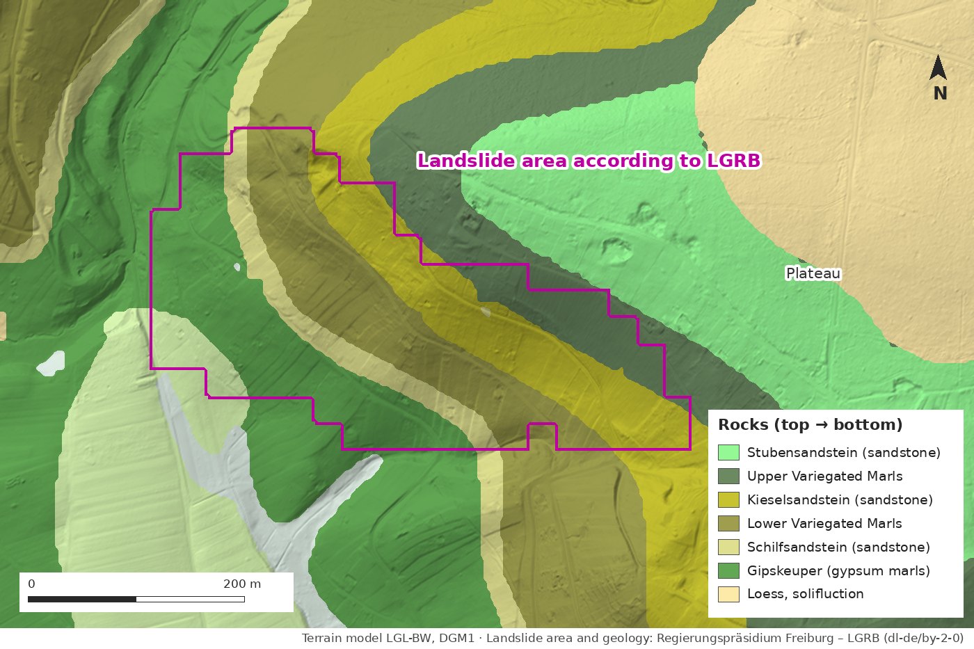
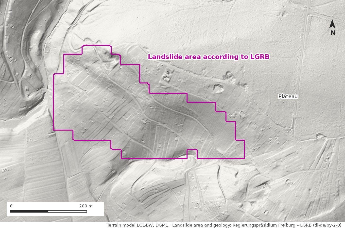
How the area was determined. The area on the Hungerberg was not mapped on site. The map gives "remote-sensing analysis" as its source: the area was derived from the terrain model that an aircraft surveyed with a laser. Old landslides leave typical forms there – scarps, steps, bulges, an uneven, hummocky surface. The stepped edges come from the State Office transferring the areas to a grid of 25 by 25 metres – deliberately, to show the uncertainty of the data.
What the area means – and what it does not. According to the State Office, landslides have already occurred in a landslide area; the map does not distinguish whether they are still active or came to rest long ago. Nor does it say anything about age or depth. A landslide can start moving again or grow, and adjacent areas can be affected too. How likely that is cannot be read from the map – it is a first assessment, not a danger level. And it is not accurate to the plot: at a scale of 1:50,000 it cannot tell whether an individual property is affected. Only an investigation on site can clarify that.
What the relief shows. Within the landslide area the slope falls from about 365 to about 280 metres, on average just under 19 degrees steep. It is not even but stepped: steep sections of around 30 degrees alternate with flatter benches. Such steps can come from hard sandstone beds, from old slid-off blocks or from former vineyard terraces – the relief alone cannot tell them apart. We do not see a fresh scarp in the terrain model.
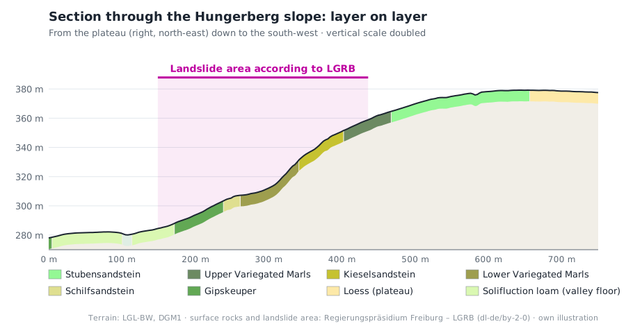
How to read the section: On the right is the plateau, on the left the valley floor. The coloured band below the ground line shows which rock lies at the surface. From the bottom up follow Gipskeuper, Schilfsandstein, Lower Variegated Marls, Kieselsandstein, Upper Variegated Marls and Stubensandstein – soft marls and hard sandstones alternating, layer on layer like a cake. The pink area is the landslide area.
The same ingredient as in Urbach. On the Hungerberg, too, sandstone – here the Kieselsandstein – lies on the Lower Variegated Marls. The landslide area reaches from the Gipskeuper up into the Upper Variegated Marls; the plateau itself is not part of it. That does not mean something like Urbach is imminent there. But it shows why experts pay attention to precisely this sequence of layers. → For comparison: Böhnlöchle and Höffenklinge
How to recognise a moving slope
Slopes that move leave traces – experts call them "silent witnesses":
- cracks in the ground, often curved across the slope, and steps or bulges at the foot of the slope
- leaning trees and sabre-shaped trunks: stems that bend downhill at the bottom and then grow straight up again – the tree kept righting itself while the ground beneath it moved
- new wet patches, springs where there were none before, or springs that suddenly dry up
- on houses and walls: cracks that grow, sticking doors and windows, warped fences, broken pipes
Anyone who notices something like this should photograph it, note the location and report it to the municipality. The State Office for Geology is responsible for the expert assessment.
What forest, meadow and vineyard walls have to do with it
Forest. Roots knit the soil together like reinforcement in concrete. According to a leaflet of the Canton of Bern, however, this mechanical effect only reaches down to about one metre; with deeper sliding surfaces as in Urbach it hardly helps. The forest's second effect remains important, and it works for deeper landslides too: the crowns hold back part of the rain, and the trees evaporate large amounts of water. The ground therefore fills up more slowly. If a slope is cleared, the roots rot over time – and the hold goes with them.
Orchard meadow. A well-kept meadow also protects its slope. The dense turf protects the surface: it dries out less and does not crust. So the soil stays able to take in water almost all year round; rain soaks in instead of running off and cutting channels. The fruit trees in it root deeper than the grass. → Forest or meadow?
Vineyard walls. Dry-stone walls and terraces slow the water and hold the soil. According to the State Statistical Office, the planted vineyard area in the Remstal wine district fell by about ten percent from 2020 to 2025, and fallow land is seen above all on terraced steep slopes. The risk for the slope lies less in the fallow plots themselves – if a plot grows over, it can even take up rain better than open vineyard soil – than in collapsing walls and bare ground. Studies from other vineyard and terrace landscapes show: where walls collapse, channels, erosion and small landslides follow. → Vineyards of tomorrow · → Traces in the Hungerberg
Frequently asked questions
Could a landslide like Urbach's happen in Winterbach?
The rocks are the same, and there are steep Keuper slopes here too. It cannot be ruled out entirely anywhere in the Keuper uplands. Whether a particular slope is at risk only an expert investigation can say; the responsible authority is the State Office for Geology, Raw Materials and Mining.
Are there landslide areas in Winterbach?
Yes. The engineering-geological hazard indication map of the State Office records about 147 hectares in the municipal area, mainly at the foot of the Schurwald in the Knollenmergel marls, plus one area on the south-west slope of the Hungerberg. According to the State Office, landslides have already occurred there; the map does not say whether they are still active, how old they are or how likely new movement is.
Does heavy rain trigger a landslide?
Small, shallow slides and mudflows can occur after heavy rain. Deep landslides like Urbach's, on the other hand, depend on water building up in the rock – and that collects over weeks.
Does forest protect against landslides?
Against shallow landslides clearly, because roots hold the soil together down to about one metre. With deep sliding surfaces they hardly help mechanically, but the forest takes water out of the slope.
How can I tell that a slope is moving?
By cracks in the ground, bulges at the foot of the slope, leaning trees and sabre-shaped trunks, new wet patches, and cracks, sticking doors and warped fences on buildings.
Whom do I tell if I notice something?
The municipality. The State Office for Geology, Raw Materials and Mining is responsible for the geological assessment.
Sources: Ski-run colours: Salzburger Nachrichten, “Mit System durchs Skigebiet” (DIN 32912, ÖNORM S 4610 f) · Elevation profile: LGL Baden-Württemberg, DGM1, Data licence Germany – attribution 2.0, simplified to 10 m · LGRB, "Der Urbacher Bergrutsch", LGRB-Nachrichten 1/2001 · LGRBwissen, "Hangrutschung Kirchsteigtobel bei Urbach" · Geotouren, "Urbach: Bergrutsch-Rundweg" (nature reserve since 2008) · Office for Forests and Natural Hazards of the Canton of Bern, leaflet "Waldbau in rutschgefährdeten Gebieten" (August 2024) · Graf, Böll, Graf: "Pflanzen im Einsatz gegen Erosion und oberflächennahe Rutschungen", WSL practice leaflet 37 (2003) · Helmholtz Centre for Environmental Research (UFZ), German Drought Monitor · State Statistical Office of Baden-Württemberg, vineyard area survey (monthly bulletin 8/2026) · Arnáez et al. (2015), Catena 128; Lesschen et al. (2008), Earth Surface Processes and Landforms 33 (terrace abandonment and erosion) · Data source: Regierungspräsidium Freiburg – LGRB, engineering-geological hazard indication map 1:50,000 (IGHK50, landslide areas; data description "readme dIGHK50") and geological map (GeoLa), retrieved 14.10.2026, Data licence Germany – attribution 2.0; areas and section: own analysis · Slope angles and relief: own analysis of the terrain model LGL-BW, DGM1 (dl-de/by-2-0)
Last updated: 15 October 2026 · Initiative Remswelle