
Rems and Winterbach · River, water, nature and history
Wind and weather in Winterbach
Surfers check wind, weather and water before every session – and for surf spots there are wind and climate calendars: month by month, how often the wind blows, how warm air and water are and which wetsuit fits. We have made such a calendar for Winterbach and the Rems. The Rems valley is no windsurfing spot – but for wing inline skating (inline skates and a hand-held wing as in wing foiling) or wind skating (a windsurf sail on a rolling board) the wind is often enough. Above all, looking at wind, air and water explains a lot about our village, from cool summer nights to the days on which the Remswelle could run. → Cool air for Winterbach
The wind and climate calendar
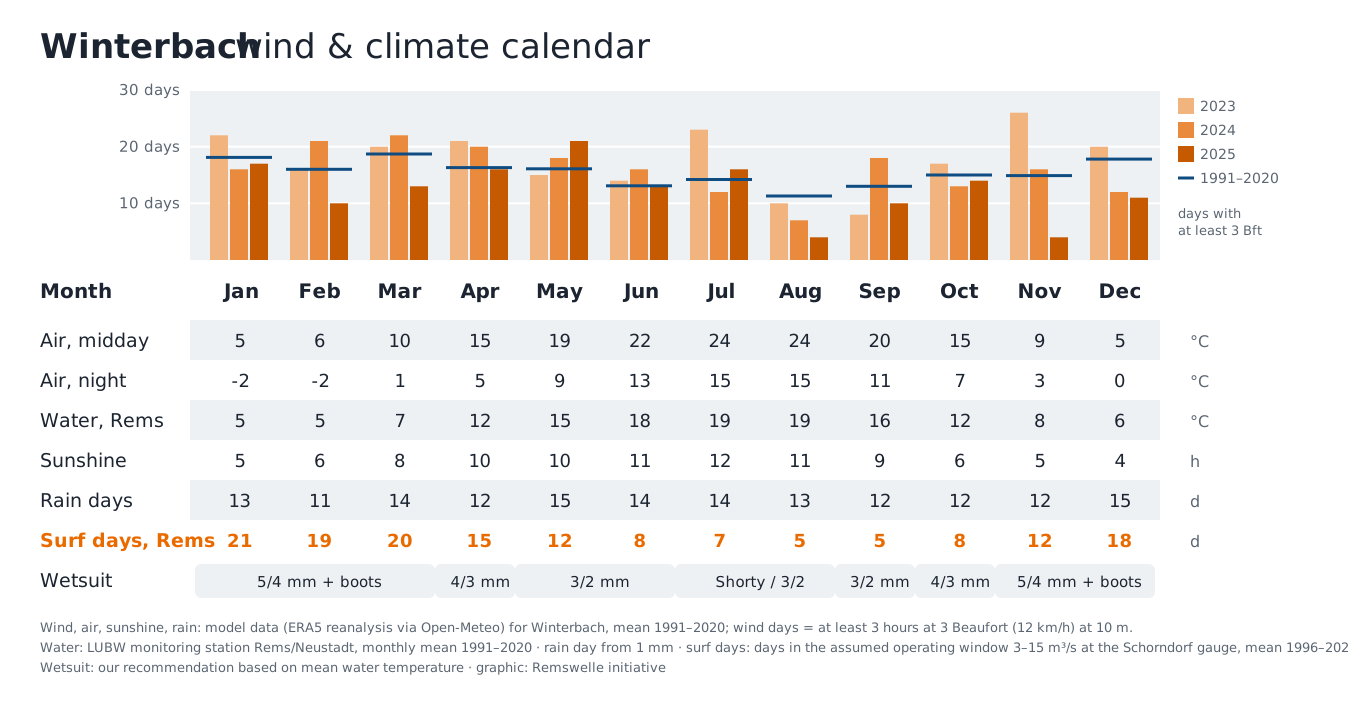
How to read it: In July it reaches 24 °C at midday on average and 15 °C at night, and the Rems is about 19 °C – but it often carries too little water, with only 7 surfable days on average. In January the water is cold at about 5 °C, but the Rems usually carries enough: about 21 surfable days. So the surf season on the Rems is rather a winter and spring season – in a thick wetsuit. → River flow and surfable days
Where the figures come from: wind, air, sunshine and rain are model data for Winterbach (the ERA5 reanalysis of the European Copernicus service, retrieved via Open-Meteo); the grid is coarse and cannot show individual streets or slopes. The water temperature, on the other hand, is measured: the State Institute for the Environment (LUBW) records it daily on the Rems at Waiblingen-Neustadt, downstream of Winterbach. The surfable days come from our analysis of the Schorndorf gauge.
Where the wind comes from – and why mostly from the west
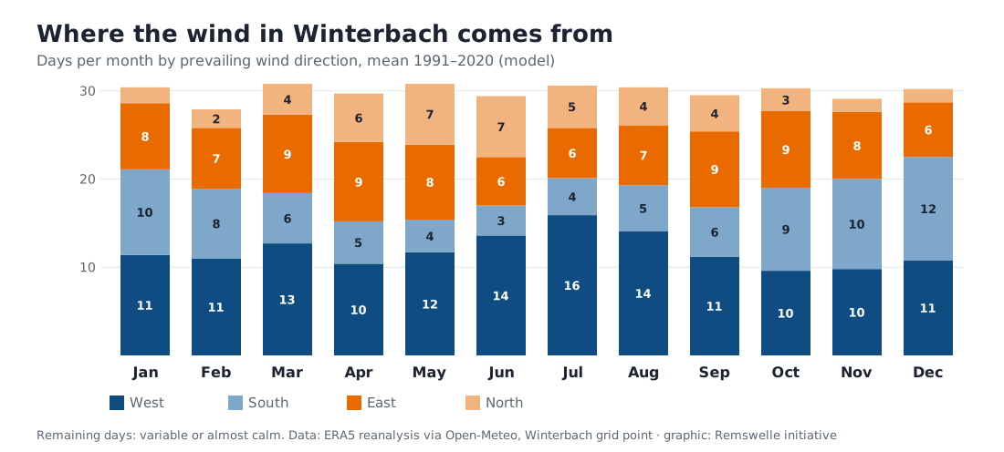
On about 140 days a year the wind in Winterbach comes mainly from the west, on about 90 days from the east, on about 80 from the south and on only about 45 from the north (mean 1991–2020).
Why westerly? There is a large difference in temperature and air pressure between the warm subtropics and the cold polar regions – for us between the Azores High in the south and the Icelandic Low in the north. The air would flow straight from high to low, but the Earth's rotation deflects it to the right in the northern hemisphere (Coriolis force). This creates a belt of westerly winds in the mid-latitudes, the "westerlies", with which low-pressure systems move east from the Atlantic. They bring most of the rain and, in winter, the strongest winds. Days with at least 3 Beaufort (from 12 km/h, for at least three hours) – enough for wing inline skating and wind skating – occur in Winterbach on about 16 to 19 days a month from December to March and on about 11 to 14 in summer. Strong wind from 4 Beaufort occurs almost only in winter, about seven times a month.
The valley steers too. Near Winterbach the Rems valley runs roughly from east to west. Winds near the ground follow the valley – which is why the wind here usually comes either from the west or from the east, and rarely from the north.
Easterly wind blows when a high lies over Scandinavia or eastern Europe and brings in dry continental air: bitterly cold in winter, warm and dry in summer. In our model data easterly wind has become more frequent – from about 87 days a year in the 1990s to about 109 days in the last ten years. In 2018 and 2025, both very dry years, there were clearly more easterly than westerly days.
At night the air flows down the valley
When there is little large-scale wind, the valley develops its own wind system. During the day the slopes warm up, the air rises up the slopes and moves up the valley – eastwards here. At night this reverses: the air cools on the slopes, flows down and collects in the valley – and because the Rems valley gets lower towards the west, it flows down the valley with the Rems, westwards. So the cool night air flows exactly against the usual westerly direction. Seen from Winterbach it comes from the Lehenbach valley, the Bronnbach valley and the valley at Weiler in the south, from the Hungerberg in the north and down the valley from the direction of Schorndorf. → Cool air for Winterbach
The "trapped-heat night": when the cooling stays away
Not every summer night brings cool air down from the slopes. Clouds hold the warmth near the ground like a blanket, and wind blows the cool air away before it can collect in the valley. The heat of the day is then trapped in the valley and the village – we call this a "trapped-heat night". On a large scale the principle is known from El Niño in the Pacific: there the cold water that normally rises from the depths off South America stays away – the sea warms up and the weather goes haywire. The trapped-heat night is, so to speak, its little brother in the Rems valley: here too the usual cooling stays away, only it is the cool air from the slopes rather than cold water from the deep.
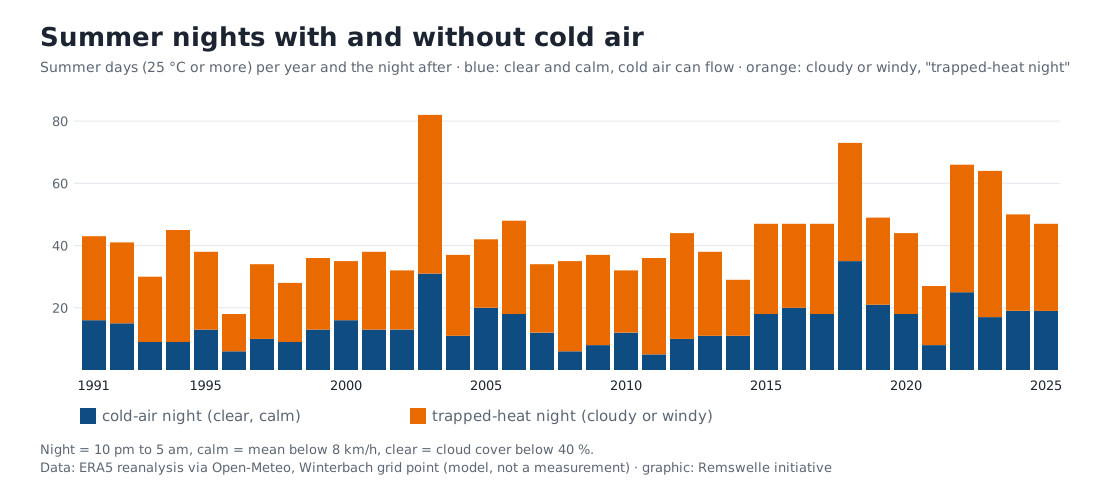
How to read the chart: each bar stands for one summer. Its height is the number of summer days, i.e. days with 25 °C or more. The colours show what happened the night after. Blue: the night was clear and calm, the slopes cooled down and cold air could flow into the valley. Orange: clouds or wind prevented this and the heat of the day stayed in the village – a "trapped-heat night".
An example: 2003 had 82 summer days. After about 31 of them the cold-air system worked during the night and it cooled down. After about 51 it did not.
On average (1991–2020) Winterbach had about 41 summer days a year (maximum of at least 25 °C). In a good third of the nights that followed, conditions for cold air were ideal – clear and calm – and in almost two thirds it was a "trapped-heat night". In the last ten years both have become more frequent because there are more summer days: 51 on average instead of 35 in the 1990s. The summers of 2003, 2018, 2022 and 2023 had the most summer days.
Nights are getting warmer all the same – measurements show it
The model for Winterbach shows hardly any further rise in warm nights since about 2001. Measurements tell a different story. Winterbach has no weather station of its own; the nearest long series of the German Meteorological Service (DWD) comes from Stuttgart-Schnarrenberg on the edge of the city. In the 1980s it was still 18 °C or more at midnight on about 43 summer evenings there – we call this a "balcony night". In the last five years the average was about 65. Tropical nights, in which it does not cool below 20 °C even in the early morning, have more than tripled: from just over 2 to 8 or 9 a year. At midnight in summer it is now on average about 2 degrees warmer than in the 1980s.
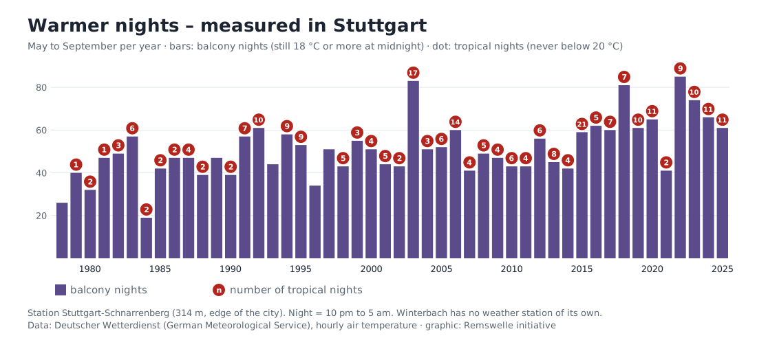
Stuttgart is not Winterbach: the warmth of the city plays a part at Schnarrenberg. At the more rural Echterdingen airport the rise is similar – balcony nights from about 31 in the 1990s to 44 in the 2010s, tropical nights from 1 to 3 a year. Winterbach is likely to lie in between. That is exactly why the cool air from the slopes matters more and more. How much difference it really makes in the village can only be measured. → What we want to test
Try it yourself: take a thermometer on a summer evening walk – once on a clear, calm night and once on a cloudy one. On the clear night the difference between the village centre and the edge of the valley is much greater.
How we count: summer day = maximum of at least 25 °C; we look at the following night from 10 pm to 5 am. Clear and calm means: on average less than 8 km/h of wind and less than 40 % cloud cover. The basis is model data, not measurements in Winterbach. We count balcony and tropical nights from the measurements of the German Meteorological Service in Stuttgart: balcony night = 18 °C or more at midnight, tropical night = even the coldest hour between 10 pm and 5 am was 20 °C or more.
The water temperature of the Rems
| Month | Jan | Feb | Mar | Apr | May | Jun | Jul | Aug | Sep | Oct | Nov | Dec |
|---|---|---|---|---|---|---|---|---|---|---|---|---|
| Mean 1991–2020 (°C) | 4.6 | 4.9 | 7.3 | 11.5 | 14.9 | 17.8 | 19.4 | 19.1 | 15.7 | 12.1 | 8.3 | 5.6 |
| 2023 | 6.7 | 6.2 | 8.4 | 10.5 | 15.1 | 20.7 | 20.8 | 19.6 | 18.3 | 13.9 | 9.8 | 7.4 |
| 2024 | 5.4 | 8.4 | 9.5 | 11.9 | 14.7 | 16.5 | 19.3 | 20.6 | 16.8 | 13.7 | 9.6 | 6.3 |
| 2025 | 5.2 | 5.7 | 8.5 | 12.9 | 15.9 | 20.5 | 20.1 | 19.3 | 15.9 | 12.4 | 8.5 | 6.2 |
Monthly means of daily means, LUBW monitoring station Rems/Neustadt.
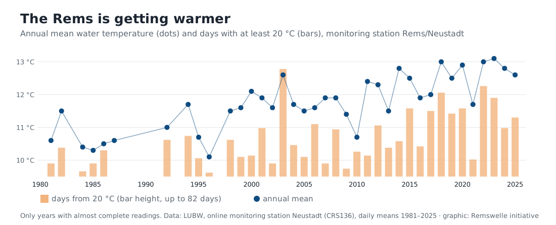
The Rems has become considerably warmer over the last decades: the annual mean was about 10.7 °C in the 1980s and about 12.6 °C in the last ten years. Days with a water temperature of at least 20 °C used to occur a good ten times a year, today more than 40 times on average – in 2003 as many as 82 times. On 27 June 2026 the daily mean reached a new record of 25.4 °C. This matters for fish: warm water holds less oxygen. → The Rems is getting warmer → Wildlife and plants · → Water quality of the Rems
What this means for the Remswelle
The Remswelle does not depend on wind but on water. The Rems carries the most water in winter and spring – exactly when air and water are cold. So surfing on the Rems usually means a thick wetsuit, boots and sometimes gloves; those who come from the sea know this from the North Sea. In summer the water is pleasantly warm, but there is often too little of it. → How many days the wave could run
Frequently asked questions
Why does the wind in Winterbach mostly blow from the west?
Because Winterbach lies in the westerly wind belt of the mid-latitudes: the pressure difference between the Azores High and the Icelandic Low and the deflection by the Earth's rotation make the air flow mainly from west to east. The Rems valley additionally steers the winds near the ground in an east–west direction.
Why does the cool night air flow westwards when the wind usually comes from the west?
The cool night air is not a wind from far away but forms locally: as heavy, cold air it flows down the slopes and then down the valley – in the Rems valley, like the Rems, to the west. This works above all on clear, calm nights when no large-scale wind blows it away.
What is a "trapped-heat night"?
Our name for a summer night after a hot day in which the cool air from the slopes stays away because clouds or wind prevent cooling. The heat of the day is then trapped in the village. It is not an official technical term – it simply describes what happens on such nights. The principle matches El Niño in the Pacific, only on a small scale: the usual cooling stays away – there the cold deep water, here the cool air from the slopes.
What is a balcony night?
Our name for a summer night in which it is still 18 °C or more at midnight – warm enough to sit outside, but also too warm to cool a flat down through open windows. Stuttgart now has about half as many balcony nights again as in the 1980s.
How warm is the Rems in summer?
Around 19 °C on average in July and August, over 22 °C on hot days (Rems/Neustadt monitoring station). In January it is just under 5 °C on average.
Can you windsurf in Winterbach?
On the water, not really – there is no suitable water. On land, yes: 3 Beaufort is enough for wing inline skating and wind skating, and Winterbach gets that on about half of all days. The Remswelle itself needs no wind – it is created by the current of the Rems.
Sources: Open-Meteo, Historical Weather API, ERA5 and ERA5-Land reanalysis (Copernicus Climate Change Service, ECMWF), Winterbach grid point, hourly values 1991–2025, accessed 28.09.2026 – own analysis · LUBW Landesanstalt für Umwelt Baden-Württemberg, online monitoring station Neustadt (CRS136), Rems, water temperature daily means 1981–2026, Daten- und Kartendienst der LUBW, accessed 28.09.2026 · Surfable days: own analysis of the Schorndorf gauge (LUBW/HVZ), 1996–2025 · Wetsuit: our recommendation · Deutscher Wetterdienst (German Meteorological Service), Climate Data Center: hourly air temperature, stations Stuttgart-Schnarrenberg (since 1977) and Stuttgart-Echterdingen (since 1988), accessed 01.10.2026 – own analysis May to September
Last updated: 15 October 2026 · Initiative Remswelle