
Rems and Winterbach · River, water, nature and history
Winterbach grows
At the beginning of the 1950s, Winterbach was still a compact village around the bridge over the Rems, surrounded by narrow fields and meadows. Today the buildings reach from the river to the edge of the forest and have grown together with Weiler. The state's aerial photographs show how this happened in seven steps – all congruent, so you can compare year by year. The areas added since the previous photograph are marked in colour; the white lines show the earlier stages.
Seven aerial photographs, one section
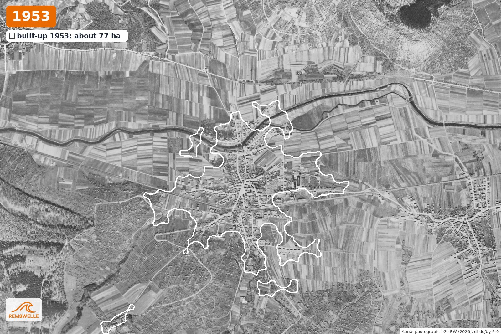
1953: The oldest aerial photograph of Winterbach held by the state. The village lies around the Rems bridge, the church and the railway, surrounded by narrow strips of fields and meadows. East of the village the Rems still meanders – by 1968 this section has been corrected too. Weiler is a separate village.
What was added when?
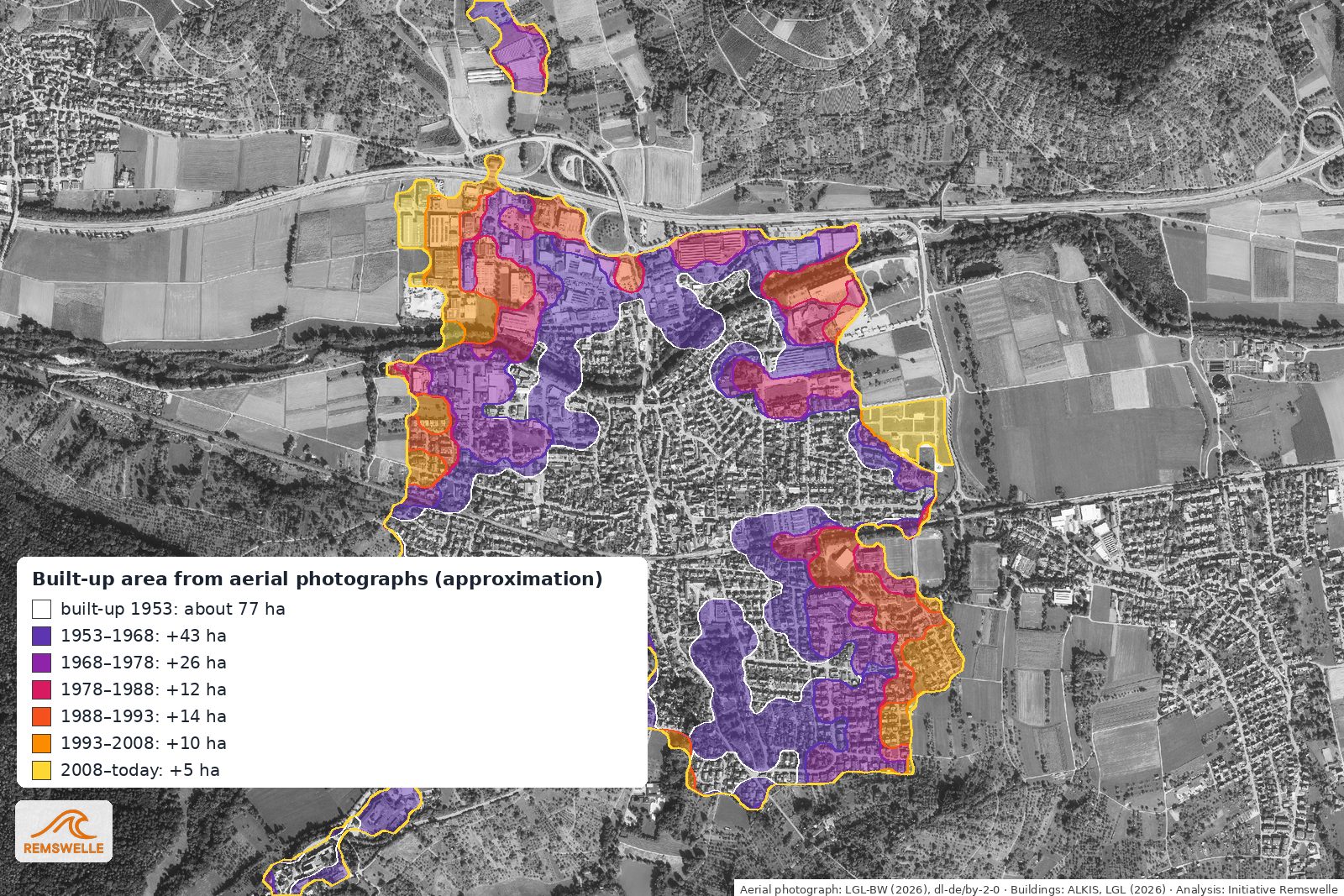
Winterbach's built-up area has roughly more than doubled since 1953 – from about 77 to about 185 hectares (without Weiler, which belongs to Schorndorf). Growth was fastest from the 1950s to the 1970s: in these two decades or so almost 70 hectares were added; after that it became less from decade to decade. Since 2008 only a few hectares have been added: above all the Riedwiesen housing area on the eastern edge between the village and Ostlandstraße (development plan 2021, about 4 hectares, services laid 2023/24) and five plots of the Eichenwäldle extension on the southern edge. Both are still hardly built on in the aerial photograph; we have drawn them in from the building land in the cadastre. Otherwise, building since 2008 has mainly taken place within the village, in gaps and on former commercial sites.
How the outlines were made. They are based on the building footprints from the official cadastre (without garages, sheds and garden houses). For each building we checked in each aerial photograph whether a roof or shadow can be seen along its outline. The earliest photograph from which it is continuously visible determines its period. Around the buildings of each stage we drew an area that includes the streets and gardens in between. The result is an approximation: buildings demolished since then are missing, and at the edges the line may be off by 20 to 30 metres. The exact years of individual areas are in the municipality's development plans.
The descriptions of the aerial photographs summarise what can be seen in the pictures. If you spot mistakes or know more, please write to us: info@remswelle.de.
Step by step or all at once?
The aerial photographs also show how housing areas came about. On the Sterrenberg it happened in stages: the Sterrenberg Ost development plan was drawn up in four construction phases from 1973 to 1976, and the area was built on mainly in the 1970s and 1980s. Then came Sterrenberg-Gaisberg (development plan 1989, built on mainly in the 1990s) and its third construction phase (1998, built on into the 2000s). So new building plots kept being added on the Sterrenberg over some three decades.
The Riedwiesen housing area came about differently: development plan 2021, about 4 hectares with about 40 building plots and about 220 homes, opened up in one go in 2023/24. Over the same period, five plots of the Eichenwäldle extension were added. According to our analysis of the development plans, Winterbach has not seen a housing area of this size in a single step in the last half century.
| Housing area | Development plan | Area approx. | Mainly built on |
|---|---|---|---|
| Sterrenbergwiesen | 1963 | 6.5 ha | 1950s and 1960s |
| Eichenwäldle – Weihergärten | 1964 | 4.6 ha | 1960s |
| Sterrenberg Ost, four construction phases | 1973–1976 | 11 ha in total | 1970s and 1980s |
| Sterrenberg-Gaisberg | 1989 | 2.8 ha | 1990s |
| Sterrenberg-Gaisberg, 3rd construction phase | 1998 | 2.8 ha | into the 2000s |
| Schießwiesen | 2002 | 2.1 ha | 2000s |
| Riedwiesen | 2021 | 4.1 ha, about 220 homes | since 2024 |
Areas: scope of the development plan according to our development plan map, rounded (Riedwiesen according to the project description). "Mainly built on": from the aerial photographs, using the same method as the outlines above. Commercial areas are not listed.
Our view: for us, new building plots are above all a chance for young people from Winterbach to start a family here and stay in the village. If a large area is allocated all at once, this chance mainly reaches those who happen to be ready at that moment. Anyone who wants to build a few years later then finds hardly anything. One argument for opening up an area in one go is that roads and utilities only have to be built once. But they could also have been prepared for the whole area and completed step by step in the later phases. We would therefore have considered a phased approach the right one, as on the Sterrenberg – for example in three thirds, spread over several years.
Phases would also have been better for soil and water. The Riedwiesen take their name from reeds and marsh ("Ried"): according to the explanatory statement of the development plan, the area used to lie partly within the 100-year flood zone, it lies almost entirely within the area of an extreme flood, and its rainwater is fed into the combined sewer. With the development, a piece of wet floodplain that could hold water is lost. If building proceeds in phases, less soil lies open and is driven over at once – compacted soil hardly absorbs water any more, and once destroyed, soil cannot be restored, as the Baden-Württemberg Ministry of the Environment stresses. And the first phase can teach lessons for the next: how groundwater, rainwater and soil behave before the whole area is built up. → What does all this have to do with surfing?
When was what built where? The development plans
Where a new housing area is built, there is usually a development plan at the start. The map shows the municipality’s development plans in force, coloured by year: light the old ones, dark the new ones. The oldest plans still in force date from the first half of the 20th century. With the “Time travel” slider you can watch the village grow plan by plan. Tap an area for number, name and year and a link to the plans at the municipality. The areas are simplified; older parts of the village that grew without a development plan stay empty.
Where no building should take place
That Winterbach cannot keep growing at will is not only due to slopes, forest and the Rems. The regional plan of the Verband Region Stuttgart, binding since 2010, defines which areas are to be kept free of development. Regional green belts secure large continuous open spaces – near Winterbach the Schurwald with its clearings, the slopes of the Hungerberg and parts of the Rems floodplain. Green breaks are narrower strips intended to prevent villages from growing together: one between Winterbach and Hebsack, one between Winterbach and Weiler. Both are objectives of spatial planning that the municipalities' land-use planning must follow.
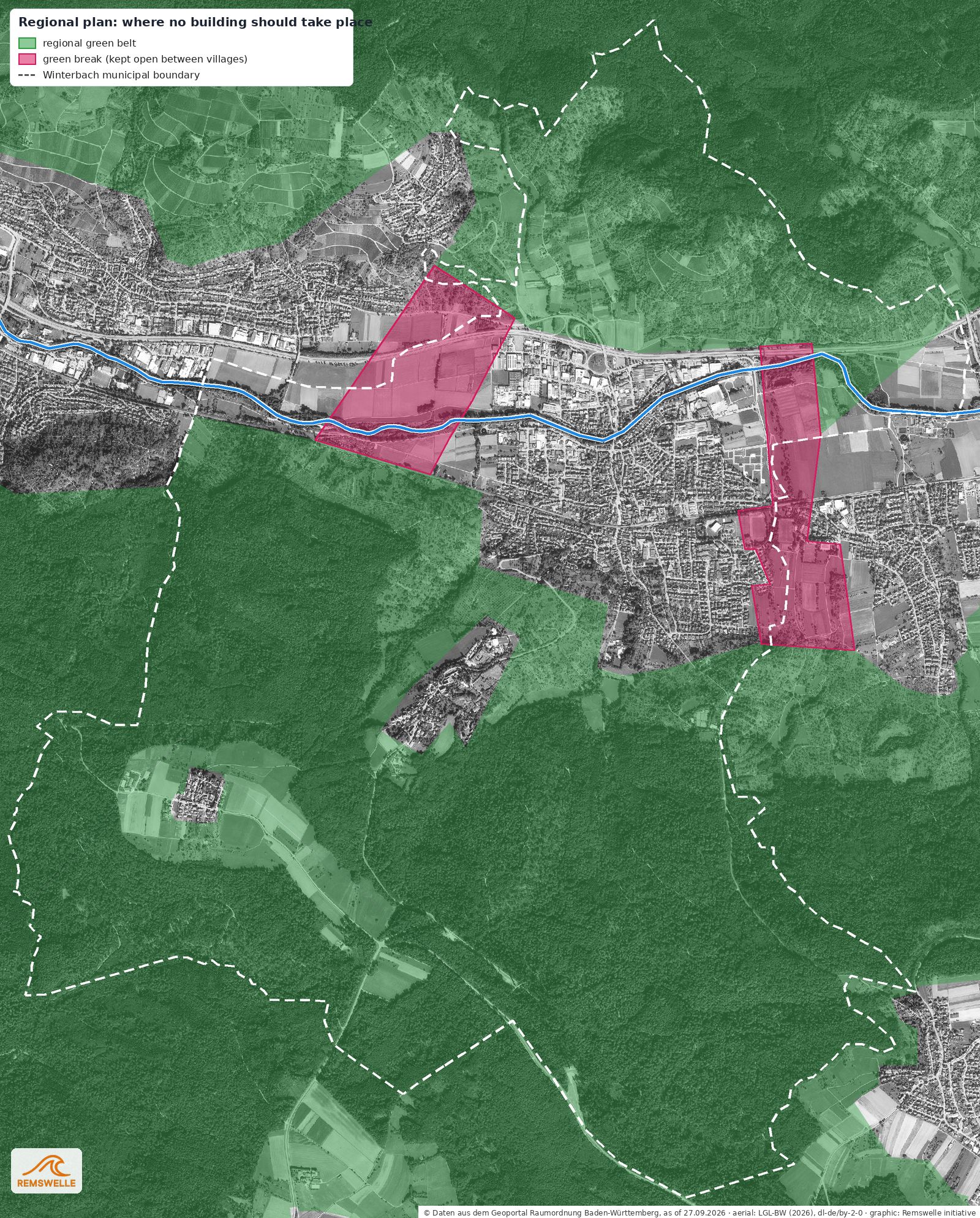
The green belts and green breaks can be shown in the map “When was what built where?” above, the protected areas in the nature map. · → Cool air for Winterbach
What this means for the Remswelle
The Remswelle does not need any new land: it is to be created in the river, at a structure that already exists. Especially in a village that has grown this much, space by the water becomes more valuable – as a meeting place and as a piece of landscape in the middle of the village. → The site · → Riverside paths along the Rems
Frequently asked questions
How much has Winterbach grown?
According to our analysis of the aerial photographs, from about 77 hectares of built-up area in 1953 to about 185 hectares today – more than double. The biggest surge came between 1953 and 1978.
Was the Riedwiesen area built all at once?
Yes. The Riedwiesen housing area (development plan 2021, about 4 hectares, about 220 homes) was opened up in one go in 2023/24. On the Sterrenberg, by contrast, building plots were added in several phases from 1973 to 1998. We would have considered phases the right approach for the Riedwiesen too, so that several age groups of young people from Winterbach could build in the village.
Where do the aerial photographs come from?
From the map services of the State Office for Geoinformation and Land Development Baden-Württemberg: historic orthophotos of the state survey flights and the current digital orthophoto. All images are georeferenced and show the same section.
What is a regional green belt?
An open space defined in the regional plan that is not to be used for settlements or larger buildings. It secures agriculture, recreation, the natural balance and the climate.
What is a green break?
A narrower strip, also to be kept free, between two villages so that they do not grow together. Near Winterbach there are two: towards Hebsack and towards Weiler.
Sources: Municipality of Winterbach, explanatory statement on the "Riedwiesen" development plan (2021) · Baden-Württemberg Ministry of the Environment, "Bodenschutz beim Bauen" · LGL Baden-Württemberg, historic digital orthophotos 1960–1969, 1970–1979, 1980–1989, 1990–1999 (1992, 1993), 2000–2009 (2007, 2008) and digital orthophoto 20 cm, Datenlizenz Deutschland – Namensnennung 2.0 · Verband Region Stuttgart, regional plan (binding since 12.11.2010), regional green belts and green breaks (priority areas), © Daten aus dem Geoportal Raumordnung Baden-Württemberg, as of 27.09.2026, dl-de/by-2-0 · Municipal boundary: LGL, ALKIS · Building footprints: ALKIS (without owner data), LGL Baden-Württemberg (2026), Datenlizenz Deutschland – Namensnennung 2.0 · Analysis of the outlines: Initiative Remswelle · Riedwiesen: Klinger und Partner, project description „Erschließung des Wohngebietes Riedwiesen in Winterbach“ · Eichenwäldle extension: Zeitungsverlag Waiblingen, 04.10.2021 and 30.07.2022 · Development plans and construction phases: Gemeinde Winterbach, list of legally binding development plans (winterbach.de, accessed 27 Sep 2026); areas and building periods: own analysis
Last updated: 15 October 2026 · Initiative Remswelle