
Rems and Winterbach · River, water, nature and history
Riverside paths along the Rems in Winterbach
The Rems flows right through Winterbach – but in many places you cannot get to it. Along the roughly 5.7 kilometres of river in the municipality, our analysis of map data finds a path on at least one bank for a good two thirds of the length, but on both banks for only about a tenth. And precisely between the village centre at Gleisdorfer Platz and the Remswehr at Ostlandstraße, where the Remswelle is to be built, there is no laid-out footpath on the bank for about one kilometre – only grass and beaten paths. Here we show what it looks like today, how the neighbouring towns do it, what a circular walk along the Rems could look like and which walks suit a visit to the Remswelle.
How it is today
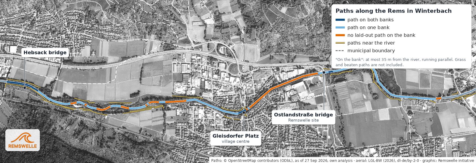
The Rems is easy to walk along below the village: along the restored section towards the Hebsack bridge, paths run on one or both banks, including a cycle path. Above the Ostlandstraße bridge a path leads towards the Remsknie, though not right by the water. In between, in the middle of the village, the piece is missing: on the south bank gardens and plots reach down to the embankment, on the north bank there are commercial sites. For the Remstal garden show in 2019 the municipality built an access to the water at Gleisdorfer Platz, with stone seating steps and a wooden deck. From there, however, you cannot yet continue along the river.
Winterbach compared
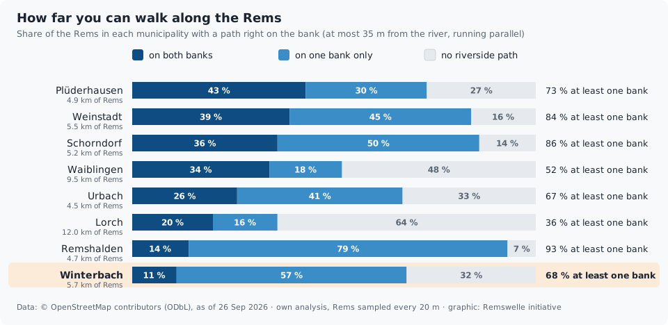
For eight municipalities on the Rems we analysed how much of the river is accompanied by a path running parallel to it at most 35 metres from the water. With 68 percent of its length having a path on at least one side, Winterbach is in the middle of the field – but last for paths on both banks, with 11 percent. In Plüderhausen it is 43 percent, in Weinstadt 39, in Schorndorf 36. The analysis is based on OpenStreetMap, not on a site survey; grass and beaten paths are mostly not included.
Vision: a circular walk along the Rems
What if you could walk from Gleisdorfer Platz along one bank to the Remswehr and back along the other? About 1.9 kilometres, in the middle of the village, always by the water. Our sketch deliberately does not yet take ownership into account – it is meant to show what would be possible, not how it could be implemented legally.
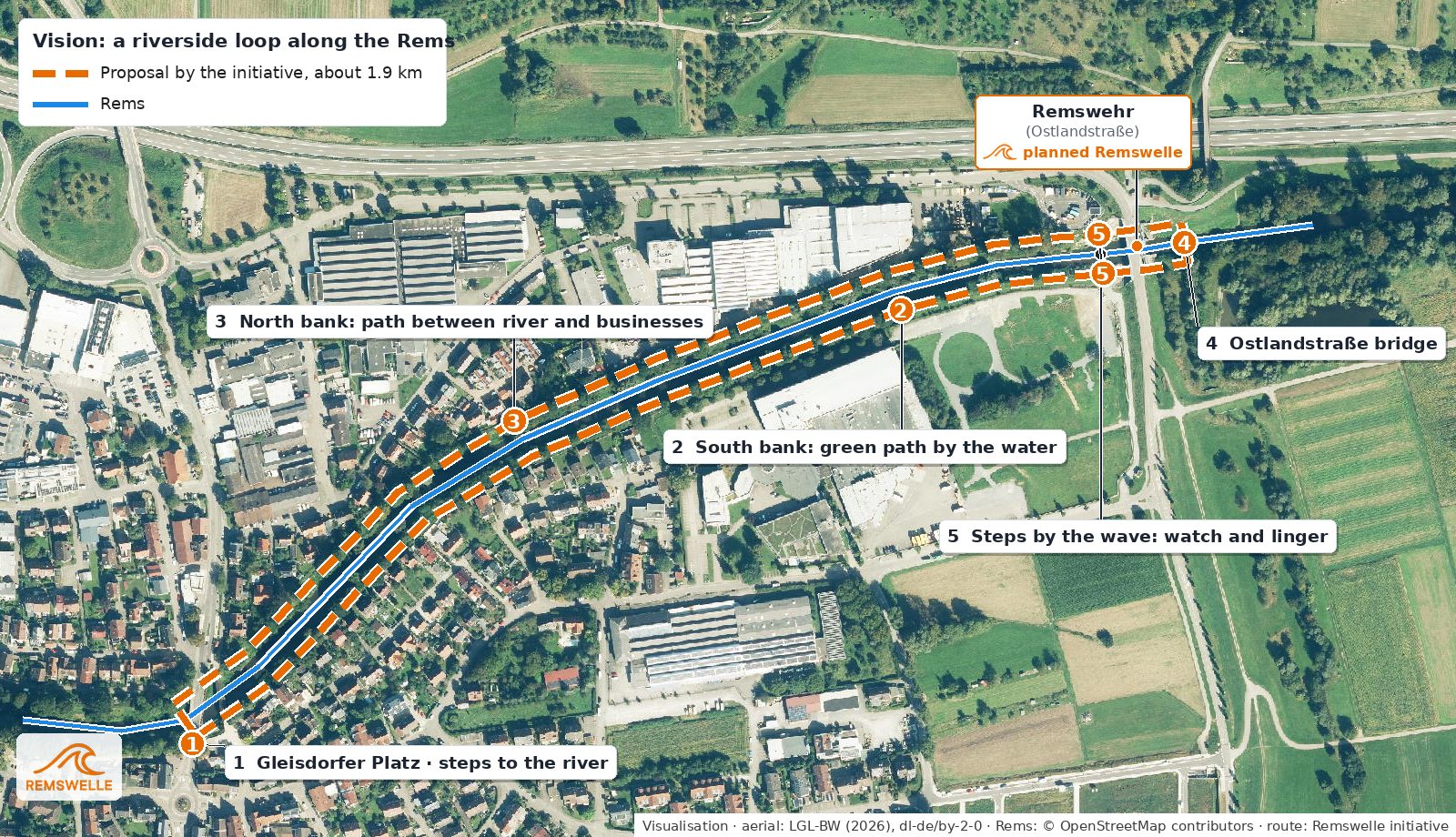
1 Gleisdorfer Platz and river access. Start and finish in the village centre, with the seating steps of 2019. 2 South bank. A narrow path through greenery close to the water, between gardens and embankment. 3 North bank. A path between river and businesses that opens the back of the sites towards the bank. 4 Ostlandstraße bridge. Here you cross to the other bank. 5 Seating steps at the wave. Steps on both banks to watch and linger – with or without surfers on the water. → The site
Such a path would link the village centre, the river access and the place to stay at the weir – for walkers, families, school classes and everyone who simply wants to be by the river. It would have to be coordinated with flood protection, river maintenance and nature conservation, for example with quiet zones for the kingfisher. → Flood protection · → Wildlife and plants
Vision: walks at the Remswelle
Not everyone who comes to the Remswelle wants to get into the water. Anyone who is watching, accompanying someone or simply has half an hour to spare should be able to do something right away. That is why we propose three loops that all start and finish at the Remswehr weir and run along the Rems for much of the way. Two of them pass an almost forgotten piece of local history: the old mill canal. It branched off the Rems just beyond the Remsknie, by today's bird tower, and led to the mill at the corner of Kanalstraße and Mühlstraße, which the district description of 1851 calls a "very important grain and gypsum mill". → How the Rems flowed in 1832
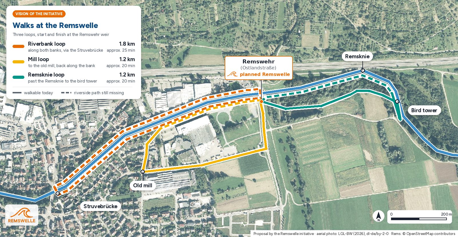
Riverbank loop, about 1.8 kilometres. From the Remswehr downstream along the north bank to the Struvebrücke in the village centre, across the Rems there and back to the weir along the south bank – the circular walk from our vision above, always by the water. Mill loop, about 1.2 kilometres. From the Remswehr via Mühlstraße to the old mill, via Kanalstraße down to the Rems and back to the weir along the bank. Remsknie loop, about 1.2 kilometres. From the Remswehr upstream along the bank to the Remsknie, the northernmost point of the Rems here, on to the bird tower, where the mill canal used to branch off, and back along the line of the old canal. The loop lies entirely within Winterbach.
Two limitations belong with this: between the old mill and the Remswehr the line of the mill canal has been built over, so the mill loop follows Mühlstraße there. And the stretches of bank between the village centre and the Remswehr do not yet exist as paths – it is the same gap that the circular walk would close. There is also no path right by the Rems from the Remswehr past the Remsknie to the bird tower yet. From the bird tower down to the mill canal weir there are already informal footpaths, and the return along the line of the old mill canal can be walked today. The loops are a proposal that would need to be agreed with the municipality, the owners and the responsible authorities. In doing so they follow the German Environment Agency's recommendation to make waters accessible to people. → Why paths by the water do you good
Why paths by the water do you good
Summers are getting hotter, and Winterbach feels it too. The Robert Koch Institute estimates around 3,000 heat-related deaths in Germany in each of the years 2023 and 2024. That makes places people can retreat to on hot days and evenings all the more important.
Places by the water are among them. A review in the Bundesgesundheitsblatt (Claßen and Bunz, 2018) sums up that people associate bodies of water with a restorative, stress-reducing effect that goes beyond that of green spaces alone. According to the studies evaluated there, water surfaces can cool urban heat islands by around 2.5 degrees. With more hot days, the authors say, such natural spaces become more important as "climate comfort islands". The EU research project BlueHealth studied from 2016 to 2020 in many European cities how rivers, lakes and coasts affect health, and names cooling, recreation, more physical activity and well-being as benefits. The German Environment Agency also recommends near-natural waters and accessible green and blue spaces to municipalities, because they improve quality of life, promote mental and physical health and strengthen social cohesion.
In Winterbach there is something more: the Rems lies at the lowest point of the valley. That is where the cool night air flowing down from the slopes arrives. A riverside path with shady trees and places to sit would therefore be an obvious place to catch your breath on summer evenings – for families, older people and everyone without a garden of their own. The honest limitation belongs here too: a path alone does not cool the village. But it makes a cooler place reachable, and it invites people to move. → Cool air for Winterbach
Across the Rems: bridges compared
Within Winterbach you can cross the Rems on foot at four places: at the Hebsack Rems bridge, in the village centre on the Ritterstraße bridge with the covered timber footbridge right next to it (Struvebrücke, 1992), at Ostlandstraße by the Remswehr, and on a farm track east of the Remsknie.
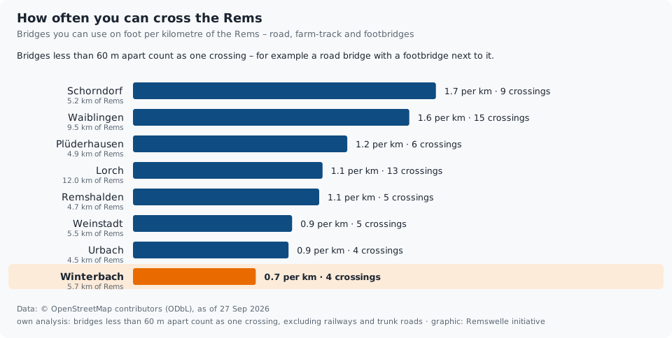
With 0.7 crossings per kilometre of the Rems, Winterbach is last of the eight municipalities analysed; Schorndorf has 1.7, Waiblingen 1.6. For the Remstal Garden Show 2019, Urbach and Weinstadt-Großheppach built new timber bridges across the Rems for pedestrians and cyclists. This analysis is also based on OpenStreetMap; small footbridges may be missing.
Frequently asked questions
Can you walk along the Rems in Winterbach?
Along a good two thirds of its length yes, at least on one bank, above all below the village along the restored section. Between Gleisdorfer Platz and the Ostlandstraße bridge there is no laid-out path on the bank for about one kilometre.
How does Winterbach compare with its neighbours?
With 68 percent of its length having a path on at least one bank it is in the middle of the field; for paths on both banks, with 11 percent, it is last of the eight municipalities analysed.
Does the circular walk already exist?
No. The circular walk is a vision of the initiative, drawn without regard to ownership and responsibilities. Whether and how it could be implemented would have to be clarified with the municipality, the owners and the responsible authorities.
Which walks are there around the Remswelle?
We propose three loops, all starting and finishing at the Remswehr: the riverbank loop along both banks to the Struvebrücke (about 1.8 kilometres), the mill loop via the old mill and Kanalstraße (about 1.2 kilometres) and the Remsknie loop past the Remsknie to where the old mill canal branched off by the bird tower (about 1.2 kilometres). The riverside paths between the village centre and the Remswehr are still missing for this today.
Why are paths along the Rems good for health?
Studies and public agencies describe places by the water as restorative and stress-reducing; water surfaces can cool their surroundings on hot days. In Winterbach the cool night air also collects in the valley along the Rems. An accessible riverside path makes this cooler place reachable for everyone and invites people to move.
How many bridges cross the Rems in Winterbach?
On foot you can cross the Rems at four places: in Hebsack, in the village centre (Ritterstraße and Struvebrücke right next to each other), at Ostlandstraße and on a farm track east of the Remsknie. That is 0.7 crossings per kilometre, the lowest value of the eight municipalities on the Rems that we analysed.
Sources: Map data © OpenStreetMap contributors (ODbL), queries via overpass-api.de on 26 and 27 September 2026, own analysis (Rems sampled every 20 metres, path at most 35 metres from the river and parallel, without private paths, bridges and tunnels; assignment to municipalities via the municipal boundaries in OpenStreetMap); bridges: query of 27 September 2026, all ways tagged as bridges that cross the Rems · Robert Koch Institute, M. an der Heiden: "Hitzebedingte Mortalität in Deutschland 2023 und 2024", Epidemiologisches Bulletin, 7 May 2025 · T. Claßen, M. Bunz: "Einfluss von Naturräumen auf die Gesundheit – Evidenzlage und Konsequenzen für Wissenschaft und Praxis", Bundesgesundheitsblatt 61 (2018) · EU project BlueHealth (Horizon 2020, 2016–2020, coordinated by the University of Exeter), CORDIS · German Environment Agency (Umweltbundesamt): "Naturbasierte Klimaanpassung in Kommunen" (2025) · Struvebrücke: brueckenweb.de, bridge sheet 44825 (built 1992, span 33.6 m) · Stuttgart timber bridges in the Rems valley: ingenieurholzbau.de · Mill: Beschreibung des Oberamts Schorndorf, 1851 (Wikisource), chapter B 27 · Mill canal: Historische Flurkarte Württemberg 1:2500, as of 1832, LGL-BW · Aerial photographs and municipal boundary: LGL Baden-Württemberg, digital orthophoto and ALKIS, Datenlizenz Deutschland – Namensnennung 2.0 · Zeitungsverlag Waiblingen, "Endlich ein Zugang zur Rems im Ort" (21.08.2018, updated 02.12.2019); "Endspurt beim Bau für die Remstal-Gartenschau" (07.01.2019)
Last updated: 15 October 2026 · Initiative Remswelle